
Strawberry, Utah facts for kids
Quick facts for kids
Strawberry, Utah
|
|
|---|---|

Strawberry, Utah
Location in Utah

Strawberry, Utah
Location in the United States
|
|
| Country | United States |
| State | Utah |
| County | Duchesne |
| Time zone | UTC-7 (Mountain (MST)) |
| • Summer (DST) | UTC-6 (MDT) |
Strawberry is a small, unincorporated community in Duchesne County, Utah, United States. An unincorporated community means it's a place where people live, but it doesn't have its own local government like a city or town. Most people in Strawberry live along the Strawberry River. This area is located west of the city of Duchesne, which is the main town in the county.
Contents
History of Strawberry
| Historical population | |||
|---|---|---|---|
| Census | Pop. | %± | |
| 1920 | 183 | — | |
| 1930 | 123 | −32.8% | |
| 1940 | 89 | −27.6% | |
| 1950 | 95 | 6.7% | |
| Source: U.S. Census Bureau | |||
Strawberry has a rich history, starting with mining and ranching. Over time, it grew into a small community.
Early Discoveries and Mining (1880-1905)
In the 1880s, a tar-like substance called Elaterite was found in the canyons near Strawberry. This led to mining operations. In 1899, the Raven Mining Company began commercial mining. They worked the mines for over 30 years. Miners often lived near the mine sites and worked seasonally.
Around 1900, a rancher named A.M. Murdock got permission to let his cattle graze in the upper Strawberry River area. In 1904, his brother Dave Murdock faced a big problem. Heavy snows trapped their cattle herd, and all the animals died. Because of this sad event, Dave Murdock named the area "Starvation Flats."
New Settlements Emerge (1905-1910)
In 1905, the Uintah Indian reservation was opened up for people to settle. The land along the Strawberry River was very appealing to new pioneers. They started clearing the thick bushes to create farms.
By 1911, two small communities had formed:
- Starvation: This community was located in the flats where Rabbit Gulch met the Strawberry River. It was about five miles west of Duchesne.
- Upper Strawberry: This settlement was in a wider part of the canyon, about four miles further west.
Even though they were close, these two communities developed separately.
The Story of Upper Strawberry (1899-Present)


The community of Upper Strawberry grew, even though there wasn't much farmland. Many residents worked as farmhands, ranch workers, or miners. A.M. Murdock had a large cattle ranch that provided jobs. The Raven Mining Company also employed many people in their Elaterite mines.
On January 1, 1921, the people of Upper Strawberry decided to change their community's name to Riverside. They wanted a name that better fit their area. The local school, originally called Strawberry No. 2, was also renamed Riverside School. This school building was very important. It served as a community center, hosting church meetings, dances, and other activities.
In late 1920, residents needed bridges across the river. With financial help from R.M. Pope and A.M. Murdock, and volunteers working for half pay, two bridges were built. This made it possible for cars to travel through the community.
Eventually, the mines closed, and the large farms were sold. In the 1930s, the CCC helped by replacing the original bridges with stronger ones. As roads improved, it became easier to travel to Duchesne, and the Riverside School eventually closed. The community slowly lost its "Riverside" identity and became more of a place where people lived but worked in Duchesne.
In 1952, high river waters flooded the canyon, washing out the CCC bridges and some houses. The community was cut off for a summer until new bridges were built. Also in 1952, power lines finally reached the canyon, bringing electricity. Before this, some farmers used wind turbines for light. Phone service arrived in 1978, and modern irrigation systems were built in 2004. Today, when people say "I live in Strawberry," they are usually talking about the old Riverside area.
The Story of Lower Strawberry (1911-1970)

The community of Starvation, also known as Lower Strawberry, was named after Starvation Flats. This wide valley area was a good place to gather sheep for shearing. In 1911, about 60,000 sheep were sheared in new corrals built there. Starvation was also on the main road to Heber, which was a big advantage.
In April 1915, a post office was opened in Starvation and named Strawberry. The first postmistress was Mrs. Vaughn Jolley. The first school in Starvation, called Strawberry School, was built around 1911. Sadly, it burned down in 1922 but was rebuilt quickly. A small cemetery was also created for the residents. In 1924, the school closed, and students were bused to Duchesne School.
The Victory Highway was built through the middle of Starvation. However, in 1970, all the land was bought by the Bureau of Reclamation to create Starvation Reservoir. The main road, US-40, was moved to the south. Today, the community of Starvation is gone, and most of its remnants are now underwater.
Geography of Strawberry
Strawberry is located in a river bottom that was once an ancient seabed. The cliffs along the canyon walls are made of layers of shells, showing its past. The area around Strawberry is known for its oil and gas wells. You can even find Elaterite, a tar-like substance, bubbling up from the ground in some places along the river.
In one unique spot, natural gases bubble up into a spring, and the foam on top can actually be lit on fire! Some springs in the area have a lot of alkaline, which you can see as white deposits on the cliff ledges.
Images for kids
-
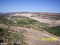
Looking west on the old "Riverside" area of Strawberry.
-
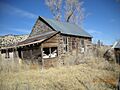
The Riverside School, built in 1912, was a community hub.
-
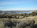
Looking across the area now covered by Starvation Reservoir.
