
Granville District facts for kids

The Granville District was a large strip of land, about 60 miles wide, in the North Carolina colony. It was located near the border with the Virginia colony. From 1663 to 1779, this land was controlled by the family of Sir George Carteret. He was one of the original "Lords Proprietor" who owned the Province of Carolina. After 1729, the Granville District made up almost half of all the land in North Carolina!
Contents
Why the District Existed
The land that became the Granville District was first part of the Carolina colony. This colony was owned by eight Lords Proprietor from 1663 to 1729. In 1729, seven of these eight owners decided to sell their shares of the colony back to the King of England (known as "The Crown").
However, the eighth share belonged to Lord Carteret. He was the great-grandson of the original owner, Sir George Carteret. Lord Carteret decided he didn't want to be involved in the colony's government anymore. Instead, he wanted to keep his share of the land.
Managing the Land from Afar
Because of political changes in England, Lord Carteret couldn't focus on his land in North Carolina until 1742. At that time, he started sending agents to manage his district. He never actually visited the land himself!
In 1742, the King's special advisors, called the "Privy Council," agreed to help Carteret plan his land area. They gave the job to Samuel Warner, a surveyor from London. He figured out that Carteret was allowed a specific amount of land based on its latitude. The northern border was set at the Virginia-North Carolina line (36° 30' north latitude). This meant the southern border would be at 35° 34' north latitude.
Mapping the Borders
In 1743, the first part of the border was surveyed. This was done by a group chosen by both Lord Carteret and North Carolina's Governor Gabriel Johnston. As more people moved west, the border line was extended further in 1746 and again in 1753.
The Granville District's Name
In 1744, Carteret received a new title: Earl of Granville. From then on, his land became known as Granville's district or simply the Granville District.
After the border was extended in 1753, other landowners, including Governor Arthur Dobbs, started to complain. They felt the line had been drawn too far south. This caused some problems because the King's government in North Carolina was still responsible for keeping the area safe and maintained. However, they didn't get any money from the Granville District's land sales.
Problems with Land Grants
Around 1750, Lord Granville became worried about how his agents were handling land grants. He gave them clear rules on how to keep records and give out land.
Despite his instructions, people kept complaining. They said the agents were charging too much money for land. One big problem involved Henry McCulloh. He had received a large land grant from the King, and some of it was inside Granville's district. Granville had given McCulloh permission to settle the land. But in 1752, he found out his own agents had given parts of McCulloh's land to other people! McCulloh and Granville argued about these areas, sometimes even threatening to go to court. Eventually, they worked out some agreements.
Growing Troubles
After Lord Granville died in 1763, the situation became even more confusing. Settlers found it hard to get clear ownership of their land. This messy situation eventually led to fighting in 1770. This fighting was known as the War of the Regulation. It happened mostly in what is now Alamance County. Governor William Tryon had to send soldiers to stop the fighting.
Granville's son, Robert Carteret, 3rd Earl Granville, thought about selling the land back to the King to solve the problems. But he never did. The situation kept getting worse, and records were no longer kept correctly. When the younger Granville died in February 1776, people in America were already very excited about the idea of revolution. The Granville District's ownership became linked to British interests.
Land Taken by the State
In 1777, the new Provisional Assembly of the State of North Carolina declared that it now controlled all the land between Virginia and South Carolina. However, it did say that land grants made by the King or the Proprietors before July 4, 1776, would still be recognized.
The Assembly also decided to take all the land and property from people who supported the British. Granville's lands were taken by the State of North Carolina in 1777. McCulloh's lands were taken in 1779. After the war, the Carteret family received some money for the land they had lost.
Images for kids
-
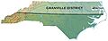
The approximate location of the dividing line between the Granville District and the Royal territory
