Province of Maine facts for kids
The Province of Maine was the name for several English colonies in North America during the 1600s. These colonies were located along the northeast coast, in what is now parts of Maine, New Hampshire, Vermont in the United States, and Quebec and New Brunswick in Canada.
The Province of Maine was created through special documents called "land patents" given by the kings of England. It included areas known as New Somersetshire, Lygonia, and Falmouth (which is now Portland, Maine). In the 1650s, the Province of Maine became part of the Massachusetts Bay Colony. This started with the creation of York County, Massachusetts, which stretched from the Piscataqua River to the Presumpscot River. Eventually, almost all of modern-day Maine became part of Massachusetts.
Quick facts for kids
Province of Maine
|
|||||||||
|---|---|---|---|---|---|---|---|---|---|
| 1622–1691 | |||||||||

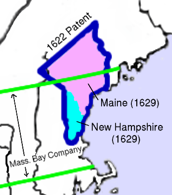
The 1622 grant of the Province of Maine is shown outlined in blue. The 1629 division into the Province of New Hampshire (south of the Piscataqua) and the Province of Maine (north of the Piscataqua) is shown by shading. The boundaries of the Massachusetts Bay Company grant are shown in green.
|
|||||||||
| Status | Disestablished | ||||||||
| Religion | Anglicanism, Congregationalism | ||||||||
| Government | Self-governing colony | ||||||||
| Governor | |||||||||
|
• 1636-1638
|
William Gorges (first) | ||||||||
|
• 1689-1692
|
Thomas Danforth (last) | ||||||||
| Historical era | British colonization of the Americas Puritan migration to New England |
||||||||
|
• Established
|
1622 | ||||||||
|
• Council for New England patent
|
1622 | ||||||||
|
• Gorges Patent
|
1639 | ||||||||
|
• Duke of York grants
|
1664 | ||||||||
| 1686-1689 | |||||||||
|
• Dissolved, incorporated into Massachusetts Bay
|
1691 | ||||||||
|
|||||||||
Contents
History of the Province of Maine
First Land Grant in 1622
The first official document creating the Province of Maine was given on August 10, 1622. It was given to two men, Sir Ferdinando Gorges and John Mason. This document came from the Plymouth Council for New England. This council itself had received a special permission from King James I. This permission allowed them to claim the North American coast between the 40th and 48th parallel.
The 1622 land grant covered the coast between the Merrimack River and the Kennebec River. It also included a piece of land between where these two rivers started. In 1629, Gorges and Mason decided to split their land. Mason kept the land south of the Piscataqua River, which became the Province of New Hampshire.
Gorges named his northern land New Somersetshire. He named it after his home county of Somerset in England. He wanted to create a community similar to the old feudal system in western England. However, he didn't have enough money or a royal charter (a special document from the king). This slowed down development. Only a few small settlements were built. The colony supported the Anglican church and the King during the English Civil War (1642–1651).
New Land Grant in 1639
In 1639, Gorges received a new land grant, called the Gorges Patent. This time, it was a royal charter directly from King Charles I of England. This new grant covered the area between the Piscataqua and Kennebec Rivers. This was roughly the same land he had after splitting with Mason in 1629.
Even with this new charter, Gorges still struggled. He lacked money and enough settlers. However, the colony managed to survive. It continued even after Gorges died in 1647.
Maine Becomes Part of Massachusetts
Starting in the 1640s, the powerful Massachusetts Bay Colony began to claim land north of the Merrimack River. They argued that the Merrimack River's northernmost point was further north than its mouth. This claim allowed them to control the early settlements that later became New Hampshire.
After a survey in the early 1650s, Massachusetts claimed land as far north as Casco Bay. By 1658, Massachusetts had taken control of all the land that Gorges had originally claimed.
In 1664, King Charles II of England gave land to his brother, James, Duke of York. This land was north and east of the Kennebec River. This area became Cornwall County, part of the Duke's own Province of New York. This new territory stretched between the Kennebec and St. Croix Rivers. This region, once called the Territory of Sagadahock, is now the eastern part of Maine.
King Charles had wanted to include Gorges' old territory in this grant. But Gorges' family chose to sell their remaining claims to Massachusetts instead.
From 1674 to 1675, the area between the Kennebec River and Penobscot Bay was managed as Devonshire County, District of Maine, Massachusetts Bay Colony. This overlapped with New York's claim. Starting in 1675, a conflict called King Philip's War caused English settlers to leave this area. They did not return until the 1700s.
In 1691, King William III and Queen Mary II issued a new charter. This charter created the new Province of Massachusetts Bay. It included the former claims of the Massachusetts Bay Colony and the Duke of York. This region first became York County, Massachusetts. Later, it was known as the District of Maine. It remained part of Massachusetts until it became its own state in 1820.
 | Bessie Coleman |
 | Spann Watson |
 | Jill E. Brown |
 | Sherman W. White |


