Presumpscot River facts for kids
Quick facts for kids Presumpscot River |
|
|---|---|

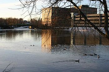
Presumpscot River at Westbrook in January 2008
|
|
 |
|
| Country | United States |
| State | Maine |
| Region | Cumberland County |
| Physical characteristics | |
| Main source | Sebago Lake 270 ft (82 m) 43°49′49″N 70°27′18″W / 43.83028°N 70.45500°W |
| River mouth | Atlantic Ocean 0 ft (0 m) 43°41′30″N 70°14′43″W / 43.69167°N 70.24528°W |
| Length | 25.8 mi (41.5 km) |
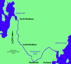
The Presumpscot River is a 25.8-mile (41.5 km) long river in Cumberland County, Maine. It flows out of Sebago Lake and makes its way to the ocean. For a long time, the river's strong water flow helped power factories in towns like Westbrook and South Windham. It also served as an important way to travel.
Contents
River's Journey: Where the Presumpscot Flows
The Presumpscot River starts at Sebago Lake and travels through several towns. These towns include Standish, Windham, Gorham, Westbrook, Portland, and Falmouth. Finally, it empties into Casco Bay in Falmouth.
Bridges Crossing the River
Many bridges cross the Presumpscot River.
- Maine State Route 35 crosses between Standish and Windham.
- A road connecting North Gorham to Windham Center also crosses it.
- The Maine Central Railroad's Mountain Division crosses twice, once near South Windham and again in Westbrook.
- U.S. Route 202 crosses in South Windham.
- U.S. Route 302 crosses at Riverton, between Westbrook and Portland.
- In Falmouth, several major roads and railways cross the river. These include Interstate 295, Maine State Routes 26 and 100, Interstate 95, Maine State Route 9, the Maine Central Railroad, and U.S. Route 1.
The Cumberland and Oxford Canal: An Old Waterway
The Presumpscot River was once a key route for transportation. It connected Casco Bay to Sebago Lake.
Building the Canal
In 1830, a system of dams and locks was finished. This created the Cumberland and Oxford Canal. Locks are like water elevators that help boats move between different water levels. The canal allowed boats to travel easily along the river.
Life of the Canal
The canal was used until 1870. After that, a railway called the Portland and Ogdensburg Railway took its place. The canal's lock system also helped control the water level of Sebago Lake. This was important because the lake acted as a reservoir, providing water to power mills along the river.
Water Control After the Canal
After the canal stopped using its locks, factories fought over who would control the river's water flow. The S. D. Warren Paper Mill in Westbrook and the Oriental Powder Company in Gorham and Windham were two of these factories. The paper mill controlled the water for over 50 years after the gunpowder factory closed in 1905.
Dams on the Presumpscot River
There are eight dams along the Presumpscot River. Dams are barriers that stop or slow the flow of water. Some of these dams are used to create hydroelectric power. This means they use the force of the water to make electricity.
List of Dams
The eight dams on the river are:
- Eel Weir Dam
- North Gorham Dam
- Dundee Dam
- Gambo Dam
- Little Falls Dam
- Mallison Dam
- Sacarappa Dam
- Cumberland Mills Dam
A Free-Flowing Section
In 2002, the Smelt Hill Dam in Falmouth was removed. Because of this, the last 7 miles (11 km) of the river, after the Cumberland Mills Dam, now flow freely to the ocean. This helps fish and other wildlife move more easily along the river.
Protecting the Presumpscot River
Efforts are being made to protect the Presumpscot River and the land around it.
Presumpscot River Preserve
The Presumpscot River Preserve is a special nature area. It is 48 acres (19 hectares) in size and is located in North Deering. This land was bought and protected in 2001. It was saved by the Land for Maine's Future program, the City Land Bank Commission, and Portland Trails.
Mile Pond Preservation
In August 2014, Portland Trails helped save another 20 acres (8.1 hectares) of land. This area is in the Presumpscot River estuary in Falmouth, near Mile Pond. Protecting these areas helps keep the river healthy for everyone.
 | May Edward Chinn |
 | Rebecca Cole |
 | Alexa Canady |
 | Dorothy Lavinia Brown |

