
Falmouth, Maine facts for kids
Quick facts for kids
Falmouth, Maine
|
||
|---|---|---|

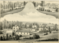
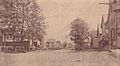
Casco Bay in 1910
|
||
|
||

Location in Cumberland County and the state of Maine.
|
||
| Country | United States | |
| State | Maine | |
| County | Cumberland | |
| Incorporated | November 12, 1718 | |
| Communities |
|
|
| Area | ||
| • Total | 36.34 sq mi (94.12 km2) | |
| • Land | 29.38 sq mi (76.09 km2) | |
| • Water | 6.96 sq mi (18.03 km2) | |
| Elevation | 102 ft (31 m) | |
| Population
(2020)
|
||
| • Total | 12,444 | |
| • Density | 423/sq mi (163.5/km2) | |
| Time zone | UTC-5 (Eastern (EST)) | |
| • Summer (DST) | UTC-4 (EDT) | |
| ZIP code |
04105
|
|
| Area code(s) | 207 | |
| FIPS code | 23-24495 | |
| GNIS feature ID | 0582472 | |

Falmouth (/ˈfɔːlməθ/ FAWL-məth) is a town in Cumberland County, Maine, United States. In 2020, about 12,444 people lived there. It is part of the larger Portland area.
Falmouth is a northern suburb of Portland. It is located next to Casco Bay, which has one of the biggest places for boats to anchor in Maine. The town has three private golf clubs and the Portland Yacht Club.
Contents
History of Falmouth
Early Native American Life
Native Americans arrived in Maine around 11,000 years ago. When Europeans first came in the 1500s, people speaking a western dialect of the Wabanaki language lived in what is now Falmouth. In 1623, explorer Christopher Levett met with the Aucocisco leader, Skittery Gusset, at his summer village near the Presumpscot Falls.
Before the English settled here, many Native Americans died from wars and diseases brought by Europeans. A big sickness between 1614 and 1620 killed up to 90% of the people living along the coast of New England. However, Native Americans still lived in the Casco Bay area until the 1740s. After the French lost battles and more settlers moved in, most Native Americans either joined British society, moved to New France, or went further up the coast where their communities still exist today.
New Casco: Early European Settlement (1630–1765)
The original area of Falmouth was much larger. It included what are now the cities of Portland, South Portland, Westbrook, and Cape Elizabeth. Today's Falmouth was known as New Casco. It was just one part of a bigger group of communities around Casco Bay.
The early years of Falmouth were very violent. It was a border area between Europeans and Native Americans. Casco Bay was the northernmost point of British settlement until 1713. Many wars between 1675 and 1763, involving the British, French, and Native Americans, often affected Falmouth. English colonists had to leave Casco Bay twice, in 1676 and 1690, because of attacks.

The first European to live here was Arthur Mackworth, around 1630. In 1658, the Massachusetts Bay Colony took control of Maine. They renamed the area Falmouth after a victory in the English Civil War. People called it "Falmouth in Casco Bay" to tell it apart from Falmouth, Massachusetts. It became an official town on November 12, 1718.
One of the first buildings in Falmouth was Fort Casco. It was a fort and trading post built in 1698 after King William's War. You can find its location today across from Pine Grove Cemetery on Route 88. Massachusetts built the fort because local Abenaki people wanted a place to trade and fix their tools. In 1701, Wabanaki leaders and Massachusetts officials formed an alliance. Two stone piles were built to show this new friendship. The nearby Two Brothers Islands got their name from this monument.
Sadly, this peace lasted less than three years. In 1702, Queen Anne's War began. Governor Joseph Dudley met with Abenaki leaders in 1703, trying to stop them from joining the French. But his efforts failed. Just two months later, the fort was attacked by Abenaki leaders and their French allies. A ship from Massachusetts, the Province Galley, saved the fort by firing its guns and scattering the attackers. Peace returned in 1713. When people started settling in what is now Portland in 1716, the Massachusetts government ordered the fort at New Casco to be torn down.
British colonists did not settle permanently in New Casco until 1759. This was after the Battle of the Plains of Abraham, which removed the threat of French and Native American attacks. Living far from Portland was dangerous. In 1725, only one family lived in the town. An attack in 1745 and a murder in 1751 showed the dangers. Most of the first permanent European settlers came after 1740. The population quickly grew to "62 families" and they formed their own church in 1753.
For the next two centuries, Falmouth's population stayed between 1,000 and 2,000 people. Residents worked in farming, fishing, and cutting down trees for ship masts. Mills on the Presumpscot River and Mussel Cove used water power to saw wood, process farm products, and make goods by the 1800s.
Modern Falmouth's Growth
In 1765, Cape Elizabeth (which included South Portland) became a separate town from Falmouth. Then, Portland broke away in 1786, and Westbrook in 1814. These separations happened because the population had grown. People wanted their own churches and felt that the main town center in Portland was too far away.
By 1859, fishing and farming were the main jobs. Other businesses included three shipbuilders, three brickmakers, a sawmill, a gristmill, and a tannery. In 1886, the town also made boots, shoes, tinware, and parts for carriages.

In 1898, trolley service from Portland reached Falmouth Foreside. This changed Falmouth from a farming community to a more urban place. Trolleys connected Falmouth to Portland's economy. The Foreside area became a popular spot for city people to relax. The Portland Yacht Club and Portland Country Club moved to Falmouth in 1885 and 1913.
To attract more riders, the Portland and Yarmouth Electric Railway Company opened Underwood Spring Park in 1899. The park had a casino, a hotel, and an outdoor theater. A fire destroyed the park in 1907, and it was not rebuilt. Another trolley line, the Portland–Lewiston Interurban, also ran through West Falmouth. But as cars became popular, trolleys stopped running in 1933.
In 1943, Percival Proctor Baxter gave Mackworth Island to the state as a wildlife refuge. Today, it is home to a state school for deaf and hard-of-hearing students.
Cars helped Falmouth become a residential suburb of Portland. Many military people moved to Falmouth when Casco Bay was a base for America's destroyer fleet from 1941 to 1944. Like many cities in the mid-1900s, people moved out of cities like Portland. They wanted cars, cheaper taxes, and more open space. Falmouth's population grew from 5,000 to over 10,000 residents in 50 years.
Falmouth's location by the ocean and its good public schools have made it a very popular place to live in the Greater Portland area. This demand led to the building of two more country clubs in 1986 and 1988. These fancy neighborhoods have made Falmouth one of the wealthiest towns in Maine.
-
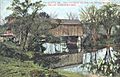
West Falmouth Manufacturing Company, 1880.
-
Downtown West Falmouth, 1880.
-
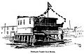
Portland Yacht Club House c. 1894
-
Presumpscot River c. 1910
-
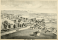
West Falmouth in 1917


Geography of Falmouth
Falmouth covers about 36.34 square miles (94.12 square kilometers). About 29.38 square miles (76.09 square kilometers) is land, and 6.96 square miles (18.03 square kilometers) is water. It is located next to Casco Bay, which is part of the Gulf of Maine and the Atlantic Ocean. The Presumpscot River flows through the town.
Major roads like Interstate 95, Interstate 295, and U. S. Route 1 cross through Falmouth. It shares borders with Cumberland to the northeast, Westbrook and Portland to the southwest, and Windham to the northwest. There are two main communities in the eastern part of town: Falmouth CDP in the south and Falmouth Foreside in the north.
People and Population
| Historical population | |||
|---|---|---|---|
| Census | Pop. | %± | |
| 1790 | 2,994 | — | |
| 1800 | 3,422 | 14.3% | |
| 1810 | 4,105 | 20.0% | |
| 1820 | 1,679 | −59.1% | |
| 1830 | 1,966 | 17.1% | |
| 1840 | 2,071 | 5.3% | |
| 1850 | 2,157 | 4.2% | |
| 1860 | 1,935 | −10.3% | |
| 1870 | 1,730 | −10.6% | |
| 1880 | 1,622 | −6.2% | |
| 1890 | 1,580 | −2.6% | |
| 1900 | 1,511 | −4.4% | |
| 1910 | 1,488 | −1.5% | |
| 1920 | 1,542 | 3.6% | |
| 1930 | 2,041 | 32.4% | |
| 1940 | 2,883 | 41.3% | |
| 1950 | 4,342 | 50.6% | |
| 1960 | 5,976 | 37.6% | |
| 1970 | 6,291 | 5.3% | |
| 1980 | 6,853 | 8.9% | |
| 1990 | 7,610 | 11.0% | |
| 2000 | 10,310 | 35.5% | |
| 2010 | 11,185 | 8.5% | |
| 2020 | 12,444 | 11.3% | |
| Sources: | |||
In 2000, the average income for a household in Falmouth was $66,855. For families, it was $87,304. About 1.8% of families and 3.7% of the total population lived below the poverty line.
2010 Census Information
In 2010, there were 11,185 people living in Falmouth. There were 4,334 households and 3,063 families. The town had about 380.7 people per square mile.
Most people in Falmouth were White (95.4%). Other groups included Asian (2.3%), African American (0.5%), and Native American (0.2%). About 1.3% of the population was Hispanic or Latino.
About 36.5% of households had children under 18. Most households (60.9%) were married couples living together. The average household had 2.54 people, and the average family had 3.05 people.
The average age in Falmouth was 45.3 years. About 25.9% of residents were under 18, and 16.8% were 65 or older. The population was 47.9% male and 52.1% female.
Places to Visit
- Falmouth Historical Society & Museum
- Falmouth Memorial Library
- Falmouth Nature Preserve
- Gilsland Farm Audubon Center
- Mackworth Island Public Reserved Land
- Maine State Ballet Theatre
- Governor Baxter School for the Deaf
- Falmouth High School
Education in Falmouth
Until 2011, Falmouth had four school buildings for students from kindergarten to 12th grade. Lunt School taught grades K-2, and Plummer-Motz taught grades 3-4. Falmouth Middle School had grades 5-8, and Falmouth High School had grades 9-12.
A new school, Falmouth Elementary School, opened in the fall of 2011. It teaches grades K-5, replacing both Lunt School and Plummer-Motz. Falmouth Middle School now teaches grades 6-8. The Falmouth School Board and Superintendent manage the schools.
Falmouth's schools are considered very good by Maine state standards. In 2011, Forbes magazine named Falmouth the "Top City to Live and Learn."
Public Facilities and Parks
Mackworth Island was given to the state by former Governor Percival Baxter. The Baxter School for the Deaf is on the island. The rest of the island is a state park open to the public, with a walking trail around the ocean.
Clapboard Island is about a mile off Falmouth Town Land. You can reach it by kayak or canoe. It has a nature preserve managed by the Maine Coast Heritage Trust.
The Family Ice Center is a non-profit ice skating facility. Its website calls it "Southern Maine’s premier year round ice skating and community center."
Notable People from Falmouth
- Mary Cunningham Agee, a business executive
- William Cranch Bond, an astronomer
- Cathy Breen, a state legislator in Maine
- Joseph Cummings, a former president of Wesleyan University and Northwestern University
- Gerald Davis, a state legislator
- Rob Derhak, a musician
- Frank Fixaris, a sportscaster
- G Hannelius, an actress
- Roger Levesque, a retired soccer player
- Mercy Lewis, a person involved in the Salem witch trials
- Helen Longley, a former First Lady of Maine
- Amy Kuhn, a state legislator
- Bob Marley, a comedian
- John R. McKernan Jr., a US congressman and former governor of Maine
- John Menario, a city manager and political candidate
- Gary Merrill, an actor
- Stanley C. Norton, a U.S. Navy Rear Admiral
- Joan Whitney Payson, a generous person and art collector
- David D. Pearce, a US ambassador
- Richard Rockefeller, a doctor and great-grandson of John D. Rockefeller Jr.
- Olympia Snowe, a US senator
- Scott Wilson, an appellate judge
See also
 In Spanish: Falmouth (Maine) para niños
