Windham, Maine facts for kids
Quick facts for kids
Windham, Maine
|
|
|---|---|

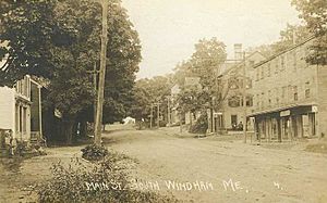
Main Street, South Windham c. 1910
|
|
| Motto(s):
Windham Works for Maine
|
|

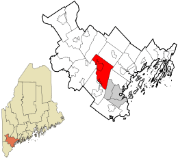
Location in Cumberland County and the state of Maine.
|
|
| Country | United States |
| State | Maine |
| County | Cumberland |
| Incorporated | June 12, 1762 |
| Villages |
|
| Area | |
| • Total | 50.15 sq mi (129.89 km2) |
| • Land | 46.56 sq mi (120.59 km2) |
| • Water | 3.59 sq mi (9.30 km2) |
| Elevation | 236 ft (72 m) |
| Population
(2020)
|
|
| • Total | 18,434 |
| • Density | 396/sq mi (152.9/km2) |
| Time zone | UTC-5 (Eastern (EST)) |
| • Summer (DST) | UTC-4 (EDT) |
| ZIP codes |
04062, 04082
|
| Area code(s) | 207 |
| FIPS code | 23-86025 |
| GNIS feature ID | 0582817 |
Windham is a town in Cumberland County, Maine, in the United States. In 2020, about 18,434 people lived there. Windham includes smaller areas called South Windham and North Windham. It is part of the larger Portland area.
Contents
Discovering Windham's Past
Windham has a long and interesting history. The land was first given out in 1734 to people from Marblehead, Massachusetts. The first settlers arrived in 1737.
Early Fort and Protection
To keep people safe during a war in 1744, a fort was built. This fort was a strong, square building called a blockhouse. It had thick walls and a second floor that hung over the first. The blockhouse was surrounded by a tall fence made of logs, called a stockade. Inside, there was a large cannon to protect the gate.
People in Windham stayed in this fort for safety between 1745 and 1751. The last attack by Native Americans happened in 1756.
Becoming a Town
On June 12, 1762, the area officially became a town named Windham. It was named after a town in England called Wymondham.
During the American Revolutionary War, people from Windham helped fight for independence. They marched to Portland in 1775 and some joined George Washington's army at Valley Forge. The town's cannon was even used on a ship during the war!
Farming and Early Industries
Most early settlers in Windham were farmers. The land near the Presumpscot River and Pleasant River was good for growing crops. Rivers also provided power for mills. By 1738, a mill was already built.
In 1817, a factory started making gunpowder at Gambo Falls. This factory grew to be very important.
The Canal Era
The Cumberland and Oxford Canal opened in 1832. This canal helped transport goods between Sebago Lake and Portland using the Presumpscot River. This made it easier for businesses in Windham to sell their products.
By 1859, Windham had many mills, including eight sawmills and a woolen factory. The gunpowder factory became the largest in Maine. It even supplied 25% of the gunpowder for the Union side during the American Civil War.
The Railroad Arrives
When the Portland and Ogdensburg Railway came through Windham in 1875, the canal was used less. The railroad made it possible to transport goods all year round. This led to new factories, like a large paper board factory in South Windham.
South Windham grew into an industrial village around this factory. By 1886, Windham also made things like felt, boots, shoes, and carriages. In 1919, a correctional center was built in South Windham, which is now the Maine Correctional Center.
Modern Highways and Growth
In 1919, a major road called the Roosevelt Trail (now U.S. Route 302) was created. This brought more tourists and cars through North Windham.
North Windham became the main business center of the town. This was because more people were driving cars for vacations to Sebago Lake and for commuting to Portland.
Windham's Geography
Windham covers about 50 square miles (129.89 square kilometers). Most of this is land, but about 3.59 square miles (9.30 square kilometers) is water. The town is located next to Sebago Lake. The Pleasant River and the Presumpscot River flow through Windham.
| Climate data for Windham, Maine | |||||||||||||
|---|---|---|---|---|---|---|---|---|---|---|---|---|---|
| Month | Jan | Feb | Mar | Apr | May | Jun | Jul | Aug | Sep | Oct | Nov | Dec | Year |
| Record high °F (°C) | 64 (18) |
64 (18) |
77 (25) |
85 (29) |
94 (34) |
97 (36) |
99 (37) |
103 (39) |
95 (35) |
88 (31) |
76 (24) |
69 (21) |
103 (39) |
| Mean daily maximum °F (°C) | 30.3 (−0.9) |
34.1 (1.2) |
42.2 (5.7) |
54.1 (12.3) |
65.1 (18.4) |
74.2 (23.4) |
79.4 (26.3) |
78.5 (25.8) |
70.3 (21.3) |
58.6 (14.8) |
47.1 (8.4) |
36.0 (2.2) |
55.8 (13.2) |
| Mean daily minimum °F (°C) | 10.8 (−11.8) |
13.7 (−10.2) |
22.9 (−5.1) |
33.7 (0.9) |
43.7 (6.5) |
53.2 (11.8) |
58.8 (14.9) |
57.5 (14.2) |
49.5 (9.7) |
37.9 (3.3) |
29.3 (−1.5) |
18.4 (−7.6) |
35.8 (2.1) |
| Record low °F (°C) | −26 (−32) |
−25 (−32) |
−21 (−29) |
8 (−13) |
23 (−5) |
35 (2) |
40 (4) |
33 (1) |
26 (−3) |
15 (−9) |
3 (−16) |
−21 (−29) |
−26 (−32) |
| Average precipitation inches (mm) | 4.00 (102) |
3.18 (81) |
4.38 (111) |
4.39 (112) |
3.90 (99) |
3.72 (94) |
3.65 (93) |
3.32 (84) |
3.59 (91) |
4.35 (110) |
4.67 (119) |
4.13 (105) |
47.28 (1,201) |
| Average snowfall inches (cm) | 20.3 (52) |
15.1 (38) |
16.5 (42) |
3.7 (9.4) |
0 (0) |
0 (0) |
0 (0) |
0 (0) |
0 (0) |
0 (0) |
2.5 (6.4) |
16.1 (41) |
74.2 (188) |
Roads and Neighboring Towns
Several main roads go through Windham, including U.S. routes 202 and 302. State routes 4, 35, and 115 also cross the town.
Windham shares borders with many other towns. These include Standish, Gorham, Westbrook, Falmouth, Cumberland, Gray, and Raymond.
Important Local Roads
Some important local roads connect different parts of Windham and nearby towns.
- Pope Road connects North Windham to Windham Center.
- River Road is a main road linking North Windham and Westbrook.
- Windham Center Road crosses the town from east to west and connects Windham Center to Gorham.
- Falmouth Road connects North Windham to Falmouth.
Parks and Fun Places
Windham has many parks and places for recreation. These include the town hall, local schools, and several parks.
Donnabeth Lippman Park
Donnabeth Lippman Park is a large park with 123 acres. It has a 10-acre pond where you can fish. There are miles of trails for hiking and biking around the pond. The park also has a story-walk trail and a playground. You can see many different birds and wildlife here.
Dundee Park
Dundee Park has a beach and a picnic area with outdoor grills. It is located along the Presumpscot River. You can also play basketball and volleyball at the park.
Windham's Population Over Time
| Historical population | |||
|---|---|---|---|
| Census | Pop. | %± | |
| 1790 | 938 | — | |
| 1800 | 1,329 | 41.7% | |
| 1810 | 1,613 | 21.4% | |
| 1820 | 1,793 | 11.2% | |
| 1830 | 2,182 | 21.7% | |
| 1840 | 2,303 | 5.5% | |
| 1850 | 2,380 | 3.3% | |
| 1860 | 2,635 | 10.7% | |
| 1870 | 2,428 | −7.9% | |
| 1880 | 2,312 | −4.8% | |
| 1890 | 2,216 | −4.2% | |
| 1900 | 1,929 | −13.0% | |
| 1910 | 1,954 | 1.3% | |
| 1920 | 1,932 | −1.1% | |
| 1930 | 2,076 | 7.5% | |
| 1940 | 2,381 | 14.7% | |
| 1950 | 3,434 | 44.2% | |
| 1960 | 4,498 | 31.0% | |
| 1970 | 6,593 | 46.6% | |
| 1980 | 11,282 | 71.1% | |
| 1990 | 13,020 | 15.4% | |
| 2000 | 14,904 | 14.5% | |
| 2010 | 17,001 | 14.1% | |
| 2020 | 18,434 | 8.4% | |
| U.S. Decennial Census | |||
The table above shows how Windham's population has grown over the years.
Famous People from Windham
- Amy Allen, a songwriter who grew up in Windham.
- John Anderson, a US congressman.
- John Albion Andrew, the 25th Governor of Massachusetts.
- Jeff Donnell, an actress known for movies and TV shows like General Hospital.
- Pamela Hayden, an actress and voice actress, famous for The Simpsons.
- Robyn Hurder, a musical theater actress who was nominated for a Tony Award.
Schools in Windham
Windham and the nearby town of Raymond share a school district called RSU 14. The schools in Windham include:
- Windham Primary School (for grades K–3)
- Manchester School (for grades 4–5)
- Windham Middle School (for grades 6–8)
- Windham High School (for grades 9–12)
Places to Visit
- Babb’s Bridge
- Windham Historical Society
- Goold House
- Maplewood Farm
See also
 In Spanish: Windham (Maine) para niños
 | Victor J. Glover |
 | Yvonne Cagle |
 | Jeanette Epps |
 | Bernard A. Harris Jr. |

