
Standish, Maine facts for kids
Quick facts for kids
Standish, Maine
|
||
|---|---|---|

View of Standish c. 1910
|
||
|
||

Location in Cumberland County and the state of Maine.
|
||
| Country | United States | |
| State | Maine | |
| County | Cumberland | |
| Incorporated | November 30, 1785 | |
| Named for | Myles Standish | |
| Villages |
|
|
| Area | ||
| • Total | 80.59 sq mi (208.73 km2) | |
| • Land | 59.03 sq mi (152.89 km2) | |
| • Water | 21.56 sq mi (55.84 km2) | |
| Elevation | 285 ft (87 m) | |
| Population
(2020)
|
||
| • Total | 10,244 | |
| • Density | 174/sq mi (67.0/km2) | |
| Time zone | UTC-5 (Eastern (EST)) | |
| • Summer (DST) | UTC-4 (EDT) | |
| ZIP Codes |
04084 (Standish)
04085 (Steep Falls) |
|
| Area code(s) | 207 | |
| FIPS code | 23-73670 | |
| GNIS feature ID | 0582744 | |

Standish is a town in Cumberland County, Maine, United States. It's a part of the greater Portland area. In 2020, about 10,244 people lived there. Standish includes several small villages like Standish Corner, Sebago Lake Village, and Steep Falls. It's a great place for outdoor activities and is also a suburb of Portland.
Contents
History of Standish, Maine
Early Days and Native Americans
Long ago, the area where Standish is now was a hunting and fishing ground for the Abenaki tribe. Their main village was called Pequawket. This was located up the Pequawket Trail, which is now Route 113.
How Standish Began
In 1750, the government of Massachusetts gave this land to two captains, Moses Pearson and Humphrey Hobbs. They received it for their service in the French and Indian Wars. The area was first called Pearson and Hobbs Town. However, Hobbs passed away, and his company didn't claim their land.
Settling the Land
In 1752, the land was measured and divided into small lots. Some soldiers sold their rights to the land. Those who did settle found their homes destroyed by Native Americans. To protect themselves, the veterans built a strong fort at Standish Corner. This fort kept them safe until 1759, when the fighting stopped.
Becoming a Town
Pearsontown Plantation officially became the town of Standish on November 30, 1785. The town was named after Myles Standish, a famous captain from early American history.
Growth and Transportation
Even though much of Standish is sandy, farmers found good land for growing crops. Watermills along the streams helped produce many things. These included lumber, barrels, carriages, clothing, and flour.
In 1832, the Cumberland and Oxford Canal opened. This made it easier to trade goods between Sebago Lake and Portland. Later, the Portland and Ogdensburg Railroad started passenger service in 1870. This meant tourists could travel by train to Sebago Lake. From there, they could ride a steamboat across the lakes. This made Standish a popular spot for visitors. The town also had train stations in Richville and Steep Falls.
In 1998, Frye Island in Sebago Lake became its own separate town. Today, Standish is known as a fun place for recreation and a community close to Portland.
-
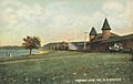
Sebago Lake Station in 1907
-
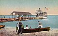
Steamboat leaving Sebago Lake c. 1915
-
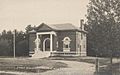
Steep Falls Library c. 1920


Geography of Standish

Standish covers about 80.59 square miles (208.73 square kilometers). A large part of this area, about 21.56 square miles (55.84 square kilometers), is water. The town is located next to Sebago Lake. Water from Standish flows into Sebago Lake and the Presumpscot River. The Presumpscot River forms the eastern border of the town. The Saco River forms the southwestern border. Watchic Lake is also found within Standish.
The town has several state roads, including Routes 11, 25, 35, 114, and 237. Standish shares its borders with several other towns. These include Windham, Gorham, Buxton, Hollis, Limington, Baldwin, and Sebago.
Population and People
| Historical population | |||
|---|---|---|---|
| Census | Pop. | %± | |
| 1790 | 716 | — | |
| 1800 | 1,226 | 71.2% | |
| 1810 | 1,378 | 12.4% | |
| 1820 | 1,619 | 17.5% | |
| 1830 | 2,023 | 25.0% | |
| 1840 | 2,198 | 8.7% | |
| 1850 | 2,290 | 4.2% | |
| 1860 | 2,067 | −9.7% | |
| 1870 | 2,089 | 1.1% | |
| 1880 | 2,035 | −2.6% | |
| 1890 | 1,841 | −9.5% | |
| 1900 | 1,504 | −18.3% | |
| 1910 | 1,637 | 8.8% | |
| 1920 | 1,735 | 6.0% | |
| 1930 | 1,317 | −24.1% | |
| 1940 | 1,472 | 11.8% | |
| 1950 | 1,786 | 21.3% | |
| 1960 | 2,095 | 17.3% | |
| 1970 | 3,122 | 49.0% | |
| 1980 | 5,946 | 90.5% | |
| 1990 | 7,678 | 29.1% | |
| 2000 | 9,285 | 20.9% | |
| 2010 | 9,874 | 6.3% | |
| 2020 | 10,244 | 3.7% | |
| U.S. Decennial Census | |||
Who Lives in Standish?
In 2010, there were 9,874 people living in Standish. Most of the people were White (97.3%). About 0.5% were African American, and 0.3% were Native American. About 0.8% of the population was Hispanic or Latino.
The average age of people in Standish was 38.8 years old. About 21.7% of residents were under 18. About 10.2% were 65 years or older. There were slightly more females (50.8%) than males (49.2%).
Famous People from Standish
- Marisa Butler – A beauty queen who was Miss Maine USA 2016 and Miss Earth USA 2021.
- Simon M. Hamlin – A US congressman.
- Albion P. Howe – A general during the Civil War.
- Solomon Nason – A farmer and politician from Wisconsin, born in Standish in 1825.
- Fandango (wrestler) – A professional wrestler.
Education in Standish
Standish is home to Bonny Eagle High School. This public high school serves students from Standish and nearby towns like Buxton, Hollis, Limington, and Frye Island.
Other schools in Standish include:
- Edna Libby Elementary
- George E. Jack Elementary
- Steep Falls Elementary
Saint Joseph's College of Maine also has its campus located in Standish.
Places to Visit in Standish
- Daniel Marrett House – This historic house from 1789 was once the home of the town's parson. It is now a museum run by Historic New England.
- The Old Red Church – Built in 1804, this old meeting house is now a museum.
- Schoolhouse Arts Center at Sebago Lake – A place for arts and performances.
- Standish Historical Society & Museum – Learn about the town's past here.
See also
 In Spanish: Standish (Maine) para niños
