
Gorham, Maine facts for kids
Quick facts for kids
Gorham, Maine
|
||
|---|---|---|

Gorham Academy Building, c. 1906
|
||
|
||
| Motto(s):
"Grow with Us"
|
||

Location in Cumberland County and the state of Maine.
|
||
| Country | United States | |
| State | Maine | |
| County | Cumberland | |
| Settled | 1736 | |
| Incorporated | October 30, 1764 | |
| Villages |
|
|
| Area | ||
| • Total | 51.29 sq mi (132.84 km2) | |
| • Land | 50.62 sq mi (131.11 km2) | |
| • Water | 0.67 sq mi (1.74 km2) | |
| Elevation | 207 ft (63 m) | |
| Population
(2020)
|
||
| • Total | 18,336 | |
| • Density | 362/sq mi (139.9/km2) | |
| Demonym(s) | Gorhamite | |
| Time zone | UTC-5 (Eastern (EST)) | |
| • Summer (DST) | UTC-4 (EDT) | |
| ZIP code |
04038
|
|
| Area code(s) | 207 | |
| FIPS code | 23-28240 | |
| GNIS feature ID | 0582493 | |

Gorham is a town located in Cumberland County, Maine, in the United States. In 2020, about 18,336 people lived there. The town has a main village center called Gorham Village. It also includes several smaller areas like South Gorham, West Gorham, Little Falls, White Rock, and North Gorham.
Gorham is home to one of the three campuses of the University of Southern Maine. In 2013, a financial website voted Gorham the second-best town in Maine. It is part of the larger metropolitan area that includes Portland, South Portland, and Biddeford.
The town was first called Narragansett Number 7. It was later renamed Gorhamtown Plantation to honor John Gorham 4th's great-grandfather, John Gorham I, a famous New England Ranger.
Contents
History of Gorham: From Settlement to Today
Gorham was first known as Narragansett Number 7. This name came from a grant by the Massachusetts General Court. The land was given to soldiers (or their families) who fought in the Narragansett War of 1675, also called King Philip's War.
Early Days and Challenges
The first settlers arrived in 1736. Captain John Phinney and his family were among them. Hugh McLellan and Daniel Mosher followed in 1738. By 1743, John Gorham built the first sawmill at Little River. Early homes were made of logs, sealed with moss and clay instead of window-glass.
The town faced attacks from Native American groups. In 1745, during King George's War, the meeting house and Gorham's sawmill were burned. Another attack in 1746 resulted in five colonists being killed and three taken away. These conflicts, part of the French and Indian Wars, ended with the 1763 Treaty of Paris.
Growth and Industry
In 1764, the town officially became Gorham. It later gained land from Standish in 1831 and 1839, and from Scarborough in 1864. The area had good soil for farming and many waterfalls. These waterfalls provided water power for factories.
Gorham grew into a busy manufacturing center. Portland was a nearby market for its goods. Factories produced things like textiles, clothing, carpets, lumber, and barrels. They also made chairs, carriages, wagons, and sleighs. Other businesses included a box factory, a corn-canning factory, a paper pulp mill, a brickyard, a tannery, and places that worked with granite and marble.
Transportation and Education
The Cumberland and Oxford Canal opened in 1829. It connected Casco Bay to Sebago Lake. However, it closed in 1871 because railroads became more popular. The York and Cumberland Railroad (later part of the Boston and Maine Railroad) reached Gorham in 1851. This railroad was removed in 1961, but its path is now a popular recreational trail.
Another railroad, the Portland and Ogdensburg Railroad, started service in 1870. It traveled from Portland to Sebago Lake through White Rock. The White Rock station closed in 1921.
In 1803, Gorham Academy was founded. The Federal style Gorham Academy Building was built in 1806. This school later became Western Maine Normal School, then Gorham State Teachers College. Today, it is the University of Southern Maine at Gorham.

Modern Gorham
Today, Gorham has less heavy industry than in the past. Most of its industrial areas are near Westbrook. Many old mills along the Presumpscot River are now underwater due to the Dundee Dam.
In recent years, Gorham has become a popular place for people who work in Portland but want to live in a quieter town. This growth has brought new homes and businesses. Gorham is also close to Sebago Lake, offering many outdoor activities. You can find trails for hiking and a river for kayaking, canoeing, and swimming.
Geography and Location
Gorham covers about 51.29 square miles (132.84 square kilometers). Most of this area is land, with a small part being water. The town is drained by the Little River, Presumpscot River, and Stroudwater River.
Roads and Neighboring Towns
Several important roads pass through Gorham. These include U.S. Route 202 and state routes 4, 22, 25, 112, 114, and 237.
Gorham shares its borders with several other towns: Buxton, Standish, Windham, Westbrook, and Scarborough.
Population Changes Over Time
| Historical population | |||
|---|---|---|---|
| Census | Pop. | %± | |
| 1800 | 2,503 | — | |
| 1810 | 2,632 | 5.2% | |
| 1820 | 2,795 | 6.2% | |
| 1830 | 2,988 | 6.9% | |
| 1840 | 3,001 | 0.4% | |
| 1850 | 3,088 | 2.9% | |
| 1860 | 3,252 | 5.3% | |
| 1870 | 3,351 | 3.0% | |
| 1880 | 3,233 | −3.5% | |
| 1890 | 2,888 | −10.7% | |
| 1900 | 2,540 | −12.0% | |
| 1910 | 2,822 | 11.1% | |
| 1920 | 2,870 | 1.7% | |
| 1930 | 3,035 | 5.7% | |
| 1940 | 3,494 | 15.1% | |
| 1950 | 4,742 | 35.7% | |
| 1960 | 5,767 | 21.6% | |
| 1970 | 7,839 | 35.9% | |
| 1980 | 10,101 | 28.9% | |
| 1990 | 11,856 | 17.4% | |
| 2000 | 14,141 | 19.3% | |
| 2010 | 16,381 | 15.8% | |
| 2020 | 18,336 | 11.9% | |
| U.S. Decennial Census | |||

In 2010, Gorham had 16,381 people living in 5,719 households. About 36% of these households had children under 18. The average age in town was 38 years old.
Education in Gorham
The schools in Gorham are part of the Gorham School District. Heather Perry is the Superintendent.
The district has three elementary schools: Village, Great Falls, and Narragansett. It also has one middle school and one high school. For the 2011-2012 school year, about 2,698 students were enrolled in the district.
Notable People from Gorham
Many interesting people have connections to Gorham:
- Wendell Abraham Anderson, a politician.
- James Phinney Baxter, a historian and community leader.
- Percival Baxter, who served as the 53rd Governor of Maine.
- Joseph Brackett, an elder in the Shakers religious group and songwriter. He wrote the famous song Simple Gifts.
- Bob Crowley, who won the TV show Survivor: Gabon. He was also a physics teacher at Gorham High School.
- Hiram Edson, an important early figure in the Seventh-day Adventist Church.
- Mackenzie Holmes, a women's basketball player.
- Stephen Longfellow, a US congressman.
- Peter Mills, a former member of the Maine state Senate, grew up in Gorham.
- Shawn Moody, a candidate for Governor of Maine in 2018, was born in Gorham.
- Frederick Robie, the 39th governor of Maine.
- Ellen G. White, a co-founder of the Seventh-day Adventist Church.
- Horace Wilson, a professor known for promoting baseball.
Images for kids
-
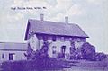
Hugh McLellan House, completed in 1773
-
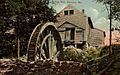
Old mill in 1906
-
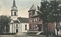
Congregational Church c. 1915


See also
 In Spanish: Gorham (Maine) para niños
