
South Portland, Maine facts for kids
Quick facts for kids
South Portland, Maine
|
|||
|---|---|---|---|

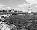
A South Portland marina overlooking the city of Portland
|
|||
|
|||
| Nickname(s):
The Park City, SoPo
|
|||
| Motto(s):
Forward
|
|||

Location in Cumberland County and the state of Maine.
|
|||
| Country | United States | ||
| State | Maine | ||
| County | Cumberland | ||
| Incorporated (town) | March 15, 1895 | ||
| Incorporated (city) | March 22, 1898 | ||
| Government | |||
| • Type | City Council and City Manager | ||
| Area | |||
| • Total | 14.01 sq mi (36.29 km2) | ||
| • Land | 12.04 sq mi (31.19 km2) | ||
| • Water | 1.97 sq mi (5.10 km2) | ||
| Elevation | 23 ft (7 m) | ||
| Population
(2020)
|
|||
| • Total | 26,498 | ||
| • Density | 2,200.10/sq mi (849.49/km2) | ||
| Time zone | UTC-5 (Eastern (EST)) | ||
| • Summer (DST) | UTC-4 (EDT) | ||
| ZIP Codes |
04106, 04116
|
||
| Area code(s) | 207 | ||
| FIPS code | 23-76750 | ||
| GNIS feature ID | 0575893 | ||
| Website | www.southportland.org | ||

South Portland is a city in Cumberland County, Maine, United States. It is the fourth-largest city in the state by population. In 2020, about 26,498 people lived there.
The city is known for its busy waterfront along Portland Harbor. From South Portland, you can see the skyline of Portland and the islands of Casco Bay. South Portland is a hub for shops and businesses because it's close to air, sea, rail, and highway routes. The Maine Mall, the biggest shopping mall in Maine, is located here. South Portland is also a "Tree City USA" community, meaning it cares about its trees.
Even though it's called South Portland, the city was never part of Portland. It used to be part of Cape Elizabeth. Both Cape Elizabeth and Portland were once part of a larger area called Falmouth. Cape Elizabeth, including what is now South Portland, became separate from Falmouth in 1765. South Portland is a main city in the larger Portland–South Portland–Biddeford metropolitan area.
Contents
History of South Portland
South Portland was first settled in 1630. It started as a small community with many farms. Native people attacked the village in 1724 during Father Rale's War. In 1858, the city of Portland bought land near the Fore River for a cemetery.
Becoming a Town and City
On March 15, 1895, South Portland became its own town. It separated from Cape Elizabeth because of a disagreement about where to get public drinking water. Three years later, on March 22, 1898, South Portland officially became a city. Like Portland, it planned to get its drinking water from Sebago Lake. Cape Elizabeth decided to use wells and other local water sources.
Historic Forts and Lighthouses
On South Portland's waterfront, you'll find Fort Preble. This military fort was built in 1808 to protect Portland Harbor. It was used during several American wars, including the United States Civil War, World War I, and World War II.
Near Fort Preble is Spring Point Ledge Light. The government built this lighthouse in 1897 to warn ships about a dangerous rock ledge.
Shipbuilding During World War II

In 1940, a large shipyard was built in South Portland to build cargo ships for Britain. When the United States joined World War II, the shipyard grew even bigger. It became known as the New England Shipbuilding Corporation. These shipyards built 236 "Liberty ships," which were 440 feet (134 meters) long. This was more than 10% of all Liberty ships made during the war!
At its busiest, the shipyard employed about 30,000 people. This included thousands of women who took over jobs while men went to war. The shipyard slowly closed down after the war ended in 1945. You can still see parts of the old shipyards today. There's also a memorial at Bug Light Park to honor the shipyard and its workers. This park is also home to Portland Breakwater Lighthouse, often called "Bug Light."
Long Creek Air Tragedy

On July 11, 1944, a U.S. Army plane crashed into a trailer park in South Portland. The pilot lost control while trying to land at the nearby airport. Nineteen people died, and 20 were injured. Most of them were families of shipyard workers. This was the worst plane accident in Maine's history. A memorial was built 66 years later to remember the crash and honor the victims.
Rise of Retail and Shopping

Over the past few decades, South Portland has become a major shopping area for Maine. The Mill Creek shopping center, built in the 1950s, was the first "strip mall" in Maine. It had a line of stores under one long roof with a covered walkway. Mill Creek has grown a lot since then. The area near the Casco Bay Bridge attracts many shoppers.
In the 1960s, there was a need for a large mall in Maine. A former pig farm in South Portland was chosen because it was close to the highway and easy to reach from Portland. Building The Maine Mall in the late 1960s changed the western part of South Portland. It went from a rural, farming area to the big retail center it is today.
Ferry Village and Neighborhood Growth
The oldest neighborhood in South Portland is Ferry Village. Before the Casco Bay Bridge was built, ferries carried people and goods across the harbor to Portland. The closing of the WWII shipyards changed Ferry Village a lot. However, the village has slowly recovered and is now a popular place to live.
Ferry Village has one of the most active neighborhood groups in Southern Maine. This group helped create the South Portland Land Trust. This trust helps protect open spaces in the city.
In 2006, some western neighborhoods like Redbank and Brick Hill saw new growth. Land that used to belong to the Long Creek Youth Development Center was redeveloped. It now has affordable homes, offices, and outdoor recreation areas. This project encouraged more private development nearby. In 2018, South Portland was even voted one of the best places to live in Maine.
Geography of South Portland

South Portland is next to Portland to the north. To the south, it borders Cape Elizabeth and Scarborough. To the west, it borders Westbrook.
The city covers about 14.02 square miles (36.29 square kilometers). Most of this area is land, with some water.
Neighborhoods and Districts


South Portland has several unique areas, which can be thought of as urban or suburban villages. Here are some of them:
- Ferry Village
- Cushing's Point
- Knightville
- Mill Creek
- Ligonia
- Pleasantdale
- Highland Avenue / Stanwood Park
- Skunk Hill
- Brick Hill
- Cash Corner
- Country Gardens
- The Maine Mall
- Meadowbrook
- Redbank
- Sunset Park
- Thornton Heights
- Town House Corner
- South Portland Heights
- Willard
- Loveitt's Field
- Meetinghouse Hill
- Willard Beach
Education in South Portland
South Portland has a public school system with five elementary schools: Brown, Dyer, Kaler, Skillin, and Dora L. Small. The city has one middle school, South Portland Middle School, for grades 5-8. There is also one high school, South Portland High School, with about 900 students.
There are two private schools: Holy Cross School (a Catholic school for K–8) and Greater Portland Christian School (a K–12 Christian school).
South Portland also has three colleges: Kaplan University, New England Bible College, and Southern Maine Community College.
Places of Worship

You can find many Christian churches in South Portland, including Baptist, Roman Catholic, Methodist, Nazarene, and non-denominational churches. There is also a Buddhist Peace Center and a Jewish congregation.
Media and News
Several local media groups report on news in South Portland. The South Portland Sentry is a free newspaper that covers city events and news. It is delivered to residents. Regional newspapers like The Current and The Forecaster also cover South Portland, along with Cape Elizabeth and Scarborough.
The city has its own local TV station, SPC-TV. It is sponsored by the city and broadcast on cable TV. Portland's TV and radio stations also cover South Portland news.
Economy and Business


South Portland has a varied economy. It has a busy working waterfront and a large retail center.
The Portland-Montreal Pipe Line is located here. Millions of barrels of oil are shipped to South Portland each year. This makes up a big part of the goods coming into the Port of Portland. South Portland is the northernmost oil port in the United States and has over 120 oil storage tanks.
Rigby Yard, the largest railroad yard in New England, is still in use today. It was built in 1922 and is part of the Pan Am Railways system.
The city is also home to factories for technology companies like ON Semiconductor and Texas Instruments.
The Maine Mall is the biggest and busiest mall in Maine. It attracts thousands of shoppers every year.
The main runway of Maine's busiest airport, the Portland International Jetport, is located in South Portland. However, the passenger terminal is in the city of Portland.
Transportation
The city-owned South Portland Bus Service provides public transportation throughout South Portland.
Things to See and Do

South Portland has many parks and open spaces. One popular feature is the historic Greenbelt walkway. This is a three-mile (5 km) paved trail that goes through several neighborhoods and offers views of the harbor.
Mill Creek Park is in downtown South Portland. It has a landscaped pond and a rose garden. The park hosts many local events, like summer concerts, "Art in the Park," holiday tree lighting, and ice skating in winter.
Other parks include Wainwright Farm, a recreation facility, and Hinckley Park, a 40-acre (160,000 m²) wooded area with two ponds. The city's waterfront has several marinas for boats and Willard Beach, which is the last free beach in the area.
Other attractions include:
- Calvary Cemetery
- Fort Preble
- The Maine Mall
- Portland Breakwater Light (known as Bug Light)
- Shoreway Arboretum
- South Portland Armory
- South Portland Historical Society
- South Portland Municipal Golf Course
- South Portland Public Library
- Southern Maine Community College
- Spring Point Ledge Light
Population and People
| Historical population | |||
|---|---|---|---|
| Census | Pop. | %± | |
| 1900 | 6,287 | — | |
| 1910 | 7,471 | 18.8% | |
| 1920 | 9,254 | 23.9% | |
| 1930 | 13,840 | 49.6% | |
| 1940 | 15,781 | 14.0% | |
| 1950 | 21,866 | 38.6% | |
| 1960 | 22,788 | 4.2% | |
| 1970 | 23,267 | 2.1% | |
| 1980 | 22,712 | −2.4% | |
| 1990 | 23,163 | 2.0% | |
| 2000 | 23,324 | 0.7% | |
| 2010 | 25,002 | 7.2% | |
| 2020 | 26,498 | 6.0% | |
| 2022 (est.) | 27,026 | 8.1% | |
In 2010, there were 25,002 people living in South Portland. About 91.1% of the people were White, 2.1% were African American, and 3.8% were Asian. About 2.2% of the population was Hispanic or Latino.
The average age in the city was 39.4 years. About 20.4% of residents were under 18 years old.
Famous People from South Portland
Many notable people have connections to South Portland:
- Robert G. Albion, author and history professor
- Jim Beattie, baseball pitcher
- Larry Bliss, state senator
- Lynn Bromley, state senator
- Brett Brown, basketball coach
- Peter Buck, co-founder of Subway restaurants
- Clarke Canfield, journalist and author
- Frank M. Coffin, judge and U.S. congressman
- Chris Coyne, co-founder of OkCupid
- Bob Crowley, winner of Survivor: Gabon
- Santo DiPietro, businessperson and state legislator
- Jane Eberle, state legislator
- Charlie Furbush, baseball pitcher
- Jon Gillies, hockey goaltender
- John W. Gulick, U.S. Army major general
- Simon M. Hamlin, U.S. congressman
- Frederick Hinckley, land developer and mayor
- Ed McAleney, football player
- Wes McCauley, hockey player and referee
- Terry Morrison, state legislator
- Judd Nelson, actor
- James C. Oliver, U.S. congressman
- Edward Reynolds, first Mayor of South Portland (1899–1900)
- Bill Swift, baseball pitcher
Images for kids
-
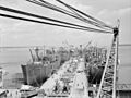
Liberty ships being built along the waterfront (August 1942)
-
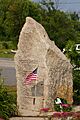
Long Creek Air Tragedy Memorial.
-
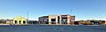
The Maine Mall circa 2023.
-
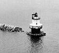
Spring Point Ledge Light breakwater under construction (1951)
-
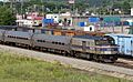
A Downeaster passenger train and a Pan Am Railways freight train at Rigby Yard in South Portland, 2005.
-
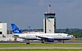
A FedEx Express cargo jet at PWM, viewed from the South Portland side of the runway, 2009.
-
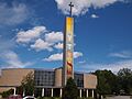
Holy Cross Church
-
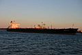
An oil tanker delivering oil to the Portland Pipeline.
-

A FedEx Express cargo jet at PWM, viewed from the South Portland side of the runway, 2009.
-
"Bug Light" with Portland's Eastern Promenade in the background.
See also
 In Spanish: South Portland para niños
