
Cape Elizabeth, Maine facts for kids
Quick facts for kids
Cape Elizabeth, Maine
|
||
|---|---|---|

The Portland Head Light, located in Cape Elizabeth
|
||
|
||
| Nicknames:
"Cape", "the Cape", "Cape Liz", "Cape Bess", "CE", "Capeside"
|
||

Location in Cumberland County and the state of Maine.
|
||
| Country | United States | |
| State | Maine | |
| County | Cumberland | |
| Incorporated/Chartered | November 1, 1765 | |
| Neighborhoods, Villages, and Communities | Cape Elizabeth Cape Cottage Delano Park Elizabeth Park Mountainview Park Pond Cove Two Lights Kettle Cove Spurwink Shores Oakhurst Shore Acres Bowery Beach Casino Beach Oceanhouse Heights Fowler Broad Cove Great Pond |
|
| Area | ||
| • Total | 45.93 sq mi (118.96 km2) | |
| • Land | 14.70 sq mi (38.07 km2) | |
| • Water | 31.23 sq mi (80.89 km2) | |
| Elevation | 62 ft (19 m) | |
| Population
(2020)
|
||
| • Total | 9,535 | |
| • Density | 649/sq mi (250.5/km2) | |
| Time zone | UTC−5 (Eastern (EST)) | |
| • Summer (DST) | UTC−4 (EDT) | |
| ZIP Code |
04107
|
|
| Area code(s) | 207 | |
| FIPS code | 23-10180 | |
| GNIS feature ID | 0582387 | |

Cape Elizabeth is a town located in Cumberland County, Maine, in the United States. It is part of the larger Portland area. In 2020, about 9,535 people lived here.
Cape Elizabeth is known as one of the wealthiest towns in Maine. It is home to the Portland Head Light, which is the oldest lighthouse in Maine. Since 1999, the town has hosted the Beach to Beacon 10K road race. This popular race starts at Crescent Beach State Park and finishes at the Portland Head Light.
The town has its own school system. The sports teams at Cape Elizabeth High School are called the "Capers."
Contents
Exploring Cape Elizabeth's Past
Early Discoveries and Names
Spanish explorers first mapped the area in 1525, calling it "Cabo de Arrecife." In May 1602, English explorer Bartholomew Gosnold arrived during his trips to what would become New England. Around 1605, Samuel de Champlain visited Richmond Island, which later became a trading post in 1628.
John Smith explored and mapped New England in 1615. He often used names given by Native Americans. When Smith showed his map to King Charles I, the King changed some names to English ones. Only four of these names are still used today, and one is Cape Elizabeth. King Charles named it after his sister, Elizabeth of Bohemia.
First European Settlers
The first Europeans settled on Richmond Island. In 1628, Walter Bagnall set up a trading post there. He traded rum and beaver skins. In 1631, he was killed, and his trading post was burned.
A few months later, the Plymouth Company gave Richmond Island to Robert Trelawney and Moses Goodyear. They made it a center for fisheries and trade. By 1638, Trelawney had 60 men working in the fisheries. The first settlers on the mainland were George Cleeve and Richard Tucker. They settled in 1630 near the Spurwink River. They farmed, fished, and traded.
In 1636, Sir Ferdinando Gorges, who owned land in Maine, gave Cleeve and Tucker 1,500 acres (6.1 km2). This land included the area now known as Portland. In 1643, Alexander Rigby bought a large land grant that included Cape Elizabeth.

Conflicts and Rebuilding
The settlement on the Fore River, called Purpoodock, was attacked during King Philip's War in 1675. During King William's War, in 1690, Major Benjamin Church led an expedition. His men were attacked at Cape Elizabeth on Purpooduc Point. Seven of his men were killed, and 24 were injured.
In 1703, during Queen Anne's War, the town was destroyed. People began to resettle the area around 1719 or 1720.
Becoming a Town
Cape Elizabeth officially became Maine's 23rd town on November 1, 1765. It separated from Falmouth, which was the name for Portland at that time. The first town meeting was held on December 2, 1765. Later, in 1895, South Portland separated from Cape Elizabeth.
In 1872, the US Army began building a fort near Portland Head Light. In 1899, this fort was named Fort Williams, after Major General Seth Williams from the Civil War. The fort was built to protect the entrance to Portland Harbor. It was active from 1899 to 1962. After that, the town bought the fort for about $200,000.
Today, Fort Williams Park is a popular spot. It includes the Portland Head Light and its museum. You can also see some parts of the old military fort and the ruins of Goddard Mansion. The park has tennis courts, a baseball field, and other fun areas. The town maintains the park, and parking fees help with repairs.
Where is Cape Elizabeth?

Cape Elizabeth covers about 45.93 square miles (118.96 km2). About 14.70 square miles (38.07 km2) is land, and 31.23 square miles (80.89 km2) is water. The town shares a border with South Portland to the north and Scarborough to the west.
The town also includes two islands:
- Ram Island: A small, uninhabited island southwest of Richmond Island.
- Richmond Island: This 226-acre (0.91 km2) island was once home to Native Americans and then English settlers. Today, it is mostly uninhabited, except for a small group of sheep.
Cape Elizabeth has three beautiful coastal parks:
The Cape Elizabeth Land Trust is a private group that protects land for public use. They look after 560 acres (2.27 km2) of land across 22 different areas. They also maintain a large network of trails for walking and other non-motorized activities. The town itself protects 923 acres (3.74 km2) of land for conservation.
People in Cape Elizabeth
In 2010, there were 9,015 people living in Cape Elizabeth. Most residents, about 96.6%, were White. About 1.4% of the population was Asian, and 0.5% was African American. About 1.4% of the population identified as Hispanic or Latino.
The average age in town was 46.8 years old. About 25% of the residents were under 18 years old. About 16.1% were 65 years or older.
Schools and Learning
The Cape Elizabeth School Department has three schools, all on one campus in the town center:
- Cape Elizabeth Elementary School
- Cape Elizabeth Middle School
- Cape Elizabeth High School
The school offices are located across the street in the Cape Elizabeth Town Hall. Cape Elizabeth also has many preschools and day care centers. The high school's first class graduated in 1877.
Ledgemere Country Day School is one of the oldest preschools in the greater Portland area. It opened in 1935 and has been operating in the same spot ever since. In November 2022, a plan to update the schools was voted on but was not approved.
Local News
Cape Elizabeth has a community newspaper called the Cape Courier. This paper is published every two weeks and is mostly run by volunteers. It was started in 1988 by Ellen Van Fleet and Jan Soland.
Another weekly newspaper, The Current, also serves the town. It started in 2001 and also covers news for nearby Scarborough and South Portland.
The first newspaper in town was The Casket, published in 1868. The Coast Watch was a weekly newspaper that started in 1895 and lasted for 20 years. In 1881, the Cape Elizabeth Sentinel was published in Ferry Village, which is now part of South Portland. This weekly newspaper was published for almost 30 years.
Fun Places to Visit
- Beach to Beacon 10K
- Cape Elizabeth Lights
- Crescent Beach State Park
- Fort Williams Park
- Portland Head Light
- Ram Island Ledge Light
- Spurwink Congregational Church
- Spurwink River
- Two Lights State Park
Famous People from Cape Elizabeth
Many interesting people have lived in Cape Elizabeth, including:
- Joan Benoit, who won a gold medal in the 1984 Olympic Marathon.
- Joy Williams, a well-known fiction writer.
- Alexander Chee, a fiction writer.
- Bette Davis, a famous actress.
- John Ford, a celebrated film director.
- Dorothy Bush Koch, sister of former president George W. Bush.
- Samuel Longfellow, a clergyman and hymn writer.
- Gary Merrill, an actor.
- Dodge Morgan, a sailor, businessman, and publisher.
- Michael Murphy, an actor.
- Sidney Toler, an actor famous for playing Charlie Chan.
Images for kids
-
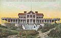
Cape Cottage Casino in 1908
-
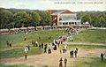
Cape Cottage Theatre in 1908
-
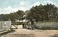
Entrance to Fort Williams in 1907
-
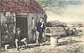
Making lobster traps c. 1904


See also
 In Spanish: Cape Elizabeth (Maine) para niños
