Fore River (Maine) facts for kids
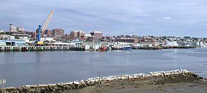
The Fore River is a special kind of waterway called an estuary. It's like a short, horn-shaped arm of the ocean, about 5.7 miles (9.2 km) long. This river separates the cities of Portland and South Portland in the state of Maine, United States. Many important port facilities for Portland's harbor are located along the Fore River.
It forms southwest of Portland where several smaller creeks join together. Long ago, the first English settler in the Casco Bay area, Captain Christopher Levett, called it Levett's River. But soon after, it became known by its current name, the Fore River.
Contents
What is an Estuary?
An estuary is a place where a river meets the sea. This mix of fresh river water and salty ocean water creates a unique environment. The Fore River is a great example of this.
Where Does the Water Come From?
The Stroudwater River flows into the Fore River estuary. In the past, from 1832 to 1870, a waterway called the Cumberland and Oxford Canal connected the Fore River to Sebago Lake through the Stroudwater River. This canal helped transport goods.
The Fore River eventually flows into Casco Bay on the southeast side of Portland. Casco Bay is part of the larger Gulf of Maine.
How Does the Water Level Change?
Like many coastal areas along the Gulf of Maine, the Fore River experiences noticeable tides. This means the water level in the river and the harbor changes a lot throughout the day. At low tide, you can often see large areas of mud flats where the water used to be. Then, at high tide, the water covers these areas again.
Bridges Over the River
Several bridges cross the Fore River, connecting Portland and South Portland. These include a bridge used by Pan Am Railways trains. There are also three highway bridges:
- The Casco Bay Bridge, which connects Portland to South Portland.
- The Veteran's Memorial Bridge, which carries Route 1.
- A causeway that carries I-295.
 | Sharif Bey |
 | Hale Woodruff |
 | Richmond Barthé |
 | Purvis Young |


