Buxton, Maine facts for kids
Quick facts for kids
Buxton
|
|
|---|---|

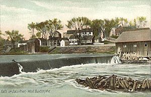
Falls on Saco River c. 1908
|
|
| Country | United States |
| State | Maine |
| County | York |
| Incorporated | 1772 |
| Government | |
| • Type | Town Meeting |
| Area | |
| • Total | 52.9 sq mi (106.79 km2) |
| • Land | 52.19 sq mi (104.95 km2) |
| • Water | 0.71 sq mi (1.84 km2) |
| Elevation | 180 ft (55 m) |
| Population
(2020)
|
|
| • Total | 8,376 |
| • Density | 207/sq mi (79.8/km2) |
| Time zone | UTC-5 (Eastern (EST)) |
| • Summer (DST) | UTC-4 (EDT) |
| ZIP code |
04093
|
| Area code(s) | 207 |
| FIPS code | 23-09410 |
| GNIS feature ID | 0582380 |
Buxton is a town located in York County, Maine, in the United States. It's part of the larger Portland area. In 2020, about 8,376 people lived here. Buxton is made up of several smaller communities, like Salmon Falls, Tory Hill, Bar Mills, and West Buxton. The old town Common is near Union Falls, where the Skelton Dam is located.
Contents
History of Buxton
Early Settlement and Naming
The land that is now Buxton was first given out in 1728 by the Massachusetts General Court. This was a special group that made laws for the Massachusetts Bay Colony. The land was given to 120 soldiers, or their families, who had fought in King Philip's War in 1675. This war was against the Narragansett Indians.
People tried to settle here in the early 1740s. But they had to leave because of the ongoing French and Indian Wars. These were fights between the British and French, often involving Native American tribes.
The first lasting settlement began in the fall of 1750. It was near Salmon Falls. This area was protected by a stockaded blockhouse and a trading post. These were built in 1728 in what is now Dayton. Amos Chase was one of the first settlers. His daughter was said to be the first white child born in Buxton. He was an important person in the area and helped start the first church in Pepperellborough (now Saco, ME).
The first school in Buxton opened in 1761. The town was officially made a town in 1772. It was named Buxton by its minister, Rev. Paul Coffin. He named it after the spa town of Buxton in Derbyshire, England.
Farming and Mills
The early settlers found that the land in Buxton was mostly flat. This made it great for farming. The main crops they grew were corn, potatoes, and hay.
Buxton also had excellent places for water power. This meant they could use the power of flowing water to run machines. The first sawmill was built on the Little River. A gristmill, which grinds grain into flour, was built at Bonny Eagle Pond.
The biggest mills were located at the falls on the Saco River.
- At Salmon Falls, sawmills could produce four million feet of lumber every year.
- Bar Mills had gristmills and a box mill.
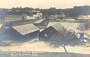
- Moderation Falls in West Buxton had sawmills and woolen textile mills. These mills made a lot of cloth, about 936,000 yards each year!
Buxton's success from its mills led to many beautiful buildings. Some of these historic places are now listed on the National Register of Historic Places. These include Elden's Store, the Buxton Powder House, the First Congregational Church, Royal Brewster House, and the Salmon Falls (East) Historic District.
Geography of Buxton
Land and Water
Buxton covers a total area of about 41.23 square miles (106.79 square kilometers). Most of this is land, about 40.52 square miles (104.95 square kilometers). The rest, about 0.71 square miles (1.84 square kilometers), is water.
The town has two main rivers: the Little River and the Saco River. There's also a lake called Bonny Eagle Pond. It's about 211 acres (0.85 square kilometers) in size and is in the northern part of town.
Neighboring Towns
Buxton shares its borders with several other towns:
- To the northeast: Gorham
- To the southeast: Scarborough and Saco
- To the south: Dayton
- To the west: Hollis
- To the northwest: Standish
Climate
Buxton has a humid continental climate. This means it has warm, humid summers and cold, snowy winters. It's similar to the climate in other nearby towns like Concord, New Hampshire.
| Climate data for West Buxton (1953–2012 normals) | |||||||||||||
|---|---|---|---|---|---|---|---|---|---|---|---|---|---|
| Month | Jan | Feb | Mar | Apr | May | Jun | Jul | Aug | Sep | Oct | Nov | Dec | Year |
| Record high °F (°C) | 69 (21) |
63 (17) |
88 (31) |
94 (34) |
94 (34) |
95 (35) |
98 (37) |
98 (37) |
97 (36) |
87 (31) |
74 (23) |
70 (21) |
98 (37) |
| Mean daily maximum °F (°C) | 30.7 (−0.7) |
34.1 (1.2) |
42.4 (5.8) |
54.7 (12.6) |
66.4 (19.1) |
75.1 (23.9) |
79.9 (26.6) |
78.5 (25.8) |
70.5 (21.4) |
59.3 (15.2) |
47.0 (8.3) |
35.2 (1.8) |
56.2 (13.4) |
| Mean daily minimum °F (°C) | 6.8 (−14.0) |
8.5 (−13.1) |
19.7 (−6.8) |
30.3 (−0.9) |
40.5 (4.7) |
50.6 (10.3) |
56.0 (13.3) |
54.1 (12.3) |
45.8 (7.7) |
34.8 (1.6) |
26.5 (−3.1) |
14.0 (−10.0) |
32.3 (0.2) |
| Record low °F (°C) | −34 (−37) |
−32 (−36) |
−22 (−30) |
5 (−15) |
20 (−7) |
32 (0) |
38 (3) |
30 (−1) |
23 (−5) |
12 (−11) |
−3 (−19) |
−31 (−35) |
−34 (−37) |
| Average precipitation inches (mm) | 3.38 (86) |
3.34 (85) |
4.07 (103) |
4.27 (108) |
3.97 (101) |
3.78 (96) |
3.64 (92) |
3.21 (82) |
3.82 (97) |
4.47 (114) |
4.85 (123) |
4.09 (104) |
46.89 (1,191) |
| Average snowfall inches (cm) | 16.0 (41) |
11.4 (29) |
8.7 (22) |
1.5 (3.8) |
0.1 (0.25) |
0 (0) |
0 (0) |
0 (0) |
0 (0) |
0.2 (0.51) |
1.4 (3.6) |
11.7 (30) |
51 (130.16) |
| Source: Desert Research Institute | |||||||||||||
People of Buxton
Population Changes Over Time
| Historical population | |||
|---|---|---|---|
| Census | Pop. | %± | |
| 1790 | 1,508 | — | |
| 1800 | 1,938 | 28.5% | |
| 1810 | 2,324 | 19.9% | |
| 1820 | 2,590 | 11.4% | |
| 1830 | 2,855 | 10.2% | |
| 1840 | 2,688 | −5.8% | |
| 1850 | 2,995 | 11.4% | |
| 1860 | 2,853 | −4.7% | |
| 1870 | 2,546 | −10.8% | |
| 1880 | 2,230 | −12.4% | |
| 1890 | 2,036 | −8.7% | |
| 1900 | 1,838 | −9.7% | |
| 1910 | 1,675 | −8.9% | |
| 1920 | 1,560 | −6.9% | |
| 1930 | 1,574 | 0.9% | |
| 1940 | 1,708 | 8.5% | |
| 1950 | 2,009 | 17.6% | |
| 1960 | 2,339 | 16.4% | |
| 1970 | 3,135 | 34.0% | |
| 1980 | 5,775 | 84.2% | |
| 1990 | 6,494 | 12.5% | |
| 2000 | 7,452 | 14.8% | |
| 2010 | 8,034 | 7.8% | |
| 2020 | 8,376 | 4.3% | |
The population of Buxton has changed a lot over the years. In 1790, there were about 1,508 people. By 2020, the population had grown to 8,376 people.
What the 2010 Census Showed
In 2010, the census (a count of the population) showed that 8,034 people lived in Buxton. There were 3,108 households, which are groups of people living together. About 2,254 of these were families.
The town had about 198 people per square mile. Most of the people (96.5%) were White. Less than 1% were African American, Native American, or Asian.
About 32.8% of households had children under 18 living there. Most households (58.5%) were married couples. The average household had about 2.58 people. The average family had about 2.94 people.
The average age of people in Buxton was 41.5 years old.
- 22.7% of residents were under 18.
- 26.1% were between 25 and 44.
- 32.6% were between 45 and 64.
- 12% were 65 or older.
Slightly more than half the population (50.4%) was male, and 49.6% was female.
Arts and Culture
If you visit Buxton, there are some interesting places to see:
- The Buxton-Hollis Historical Society and Museum: Here you can learn about the history of the area.
- The Tory Hill Meeting House (built in 1822): A historic church building.
- Brewster Mansion (built in 1805): A grand old house.
- The Powder House (built in 1813): A historic building that used to store gunpowder.
Notable People from Buxton
Many interesting people have come from Buxton, including:
- Mark Blier, a state legislator (someone who helps make laws for the state).
- Gibeon Bradbury, a painter.
- John Brewster Jr., another artist.
- Amos Chase, one of the first settlers of Buxton.
- Mark H. Dunnell, a US congressman (someone who represents the area in the national government).
- Alanson M. Kimball, also a US congressman.
- Ivory Quinby, a politician and businessman.
- Julia Spencer-Fleming, a mystery writer.
- Ellis Baker Usher, a politician from Wisconsin.
- Cyrus Woodman, a businessman.
See also
 In Spanish: Buxton (Maine) para niños
 | Ernest Everett Just |
 | Mary Jackson |
 | Emmett Chappelle |
 | Marie Maynard Daly |


