
Saco, Maine facts for kids
Quick facts for kids
Saco
|
|
|---|---|

View of Main Street
|
|
| Motto(s): | |

Location of city of Saco in Maine
|
|

Saco
Location in the United States
|
|
| Country | United States |
| State | Maine |
| County | York |
| Incorporated (district) | June 9, 1762 |
| Incorporated (town) | August 23, 1775 |
| Incorporated (city) | February 18, 1867 |
| Area | |
| • Total | 52.83 sq mi (136.83 km2) |
| • Land | 38.59 sq mi (99.93 km2) |
| • Water | 14.24 sq mi (36.89 km2) |
| Elevation | 66 ft (20 m) |
| Population
(2020)
|
|
| • Total | 20,381 |
| • Density | 528.21/sq mi (203.94/km2) |
| Time zone | UTC−5 (Eastern (EST)) |
| • Summer (DST) | UTC−4 (EDT) |
| ZIP Code |
04072
|
| Area code(s) | 207 |
| FIPS code | 23-64675 |
| GNIS feature ID | 0574646 |
| Website | www.sacomaine.org |
Saco (say 'SAH-koh') is a city in York County, Maine, USA. In 2020, about 20,381 people lived there. It's known for places like Ferry Beach State Park, Funtown Splashtown USA, and Thornton Academy. Saco is also home to a part of General Dynamics Armament Systems, a company that makes defense products.
Many tourists visit Saco in the summer. They enjoy its amusement parks, Camp Ellis Beach and Pier, Ferry Beach State Park, and how close it is to Old Orchard Beach. Saco is part of the larger Portland area. It is also considered a "twin city" with Biddeford.
Contents
History of Saco
Early Settlements and Native Peoples
The land where Saco is now was once home to the Abenaki tribe. Their main village was further up the Sokokis Trail. When Europeans first arrived in the early 1600s, there was already a village at the mouth of the Saco River. People lived there in homes and grew crops.
In July 1607, a group of 500 warriors from the Mi'kmaq tribe attacked the Abenaki village in Saco. They killed 20 Abenaki warriors, including two leaders. This led to a conflict that lasted until 1615.
European Settlement and Early Conflicts
In 1630, two men named Thomas Lewis and Richard Bonython received permission to start a town in Saco. Their land stretched about 4 miles (6.4 km) along the sea and 8 miles (13 km) inland. The town was settled in 1631 and was first called Winter Harbor. From 1636 to 1653, the government of Maine was based in Saco. In 1653, the town was reorganized and later renamed Biddeford in 1718.
Native American tribes attacked the settlement in 1675 during King Philip's War. Settlers moved closer to the river, and their empty homes and mills were burned. Saco was a disputed area between New England and New France. New France often allied with Native American tribes. In 1689, during King William's War, Saco was attacked again, and some residents were captured.
Fighting continued until 1713, when the Treaty of Portsmouth brought a brief peace. The community was rebuilt and became Biddeford in 1718. However, peace did not last. The town was attacked again in 1723 during Dummer's War. At that time, it had 14 fortified buildings called garrisons.
In 1724, a Massachusetts militia destroyed Norridgewock. This was an Abenaki stronghold that organized raids on English settlements. After this, the area became safer. The French and Indian Wars finally ended in 1763 with the Treaty of Paris.
Becoming Saco City
In 1762, the northeastern part of Biddeford became its own district called Pepperrellborough. It was named after Sir William Pepperrell, a hero from the Battle of Louisburg. Amos Chase was an important early settler. He helped lead the town and was active during the American Revolution.
The district officially became the Town of Pepperellborough in 1775. But the name was long and hard to say. So, in 1805, it was renamed Saco. It officially became a city in 1867.
Saco became a big center for lumber production. Logs were floated down the river from nearby towns. At Saco Falls, 17 sawmills cut the timber. In 1827, the community produced 21 million feet (6.4 million meters) of cut lumber. Some of this wood was used to build ships.
Industrial Growth and Decline
In 1811, the Saco Iron Works started operating on Factory Island. In 1826, the Saco Manufacturing Company built a cotton mill. A canal was dug to use water power for the mill. The mill burned down in 1830. But a new one, the York Manufacturing Company, was built in 1831.
When the Portland, Saco and Portsmouth Railroad arrived in 1842, Factory Island grew even more. It became a major textile manufacturing center. Large brick mills dominated the waterfronts of Saco and Biddeford. Other businesses included metal foundries, harness making, and machine shops.
However, the textile industry in New England declined in the 1900s. The York Manufacturing Company closed in 1958. Even so, the time when Saco was a busy mill town left behind many beautiful buildings. These buildings show different styles like Georgian, Federal, Greek Revival, and Victorian architecture. Many are now listed on the National Register of Historic Places.
In 1844, Laurel Hill Cemetery was created on 25 acres (10 hectares) of land. It is still used today and is one of the earliest examples of a "rural cemetery."
Modern Saco and Green Efforts
Saco has worked to become more environmentally friendly. In 2007, a small wind turbine was put up near the water treatment plant. Another larger turbine was built on York Hill later that year. It was meant to power the new train station for Amtrak's Downeaster. However, this turbine was taken down in 2018 because it did not produce as much energy as expected. Saco also has two growing business parks.
-
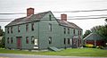
Amos Chase house on Ferry Road; built around 1743
-
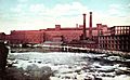
York Manufacturing Co. in 1916
-
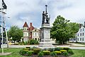
Civil War memorial in Eastman Park
-
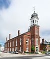
Saco City Hall
-
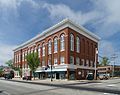
Masonic Hall


Geography and Location
Saco covers about 52.76 square miles (136.65 sq km). About 38.46 sq mi (99.61 sq km) is land, and 14.30 sq mi (37.04 sq km) is water. The city is located on Saco Bay, which is part of the Gulf of Maine. The Saco River flows through the city.
Saco shares borders with the city of Biddeford. It also borders the towns of Scarborough, Buxton, Dayton, and Old Orchard Beach.

Landforms and Coastal Changes
Saco has many different types of land. These include beaches, fields, forests, wet bogs, and city areas. The Camp Ellis beachfront part of the city has been losing sand and land. This started when the Army Corps of Engineers built a jetty in the 1860s at the mouth of the Saco River. The jetty stopped sand from reaching the Camp Ellis beaches. Rising sea levels and climate change in Maine have made this problem worse.
You can find more information about the erosion issues in Camp Ellis on the city's website.
Population and Demographics
| Historical population | |||
|---|---|---|---|
| Census | Pop. | %± | |
| 1790 | 1,350 | — | |
| 1800 | 1,842 | 36.4% | |
| 1810 | 2,492 | 35.3% | |
| 1820 | 2,532 | 1.6% | |
| 1830 | 3,219 | 27.1% | |
| 1840 | 4,408 | 36.9% | |
| 1850 | 5,798 | 31.5% | |
| 1860 | 6,223 | 7.3% | |
| 1870 | 5,755 | −7.5% | |
| 1880 | 6,389 | 11.0% | |
| 1890 | 6,075 | −4.9% | |
| 1900 | 6,122 | 0.8% | |
| 1910 | 6,583 | 7.5% | |
| 1920 | 6,817 | 3.6% | |
| 1930 | 7,233 | 6.1% | |
| 1940 | 8,631 | 19.3% | |
| 1950 | 10,324 | 19.6% | |
| 1960 | 10,515 | 1.9% | |
| 1970 | 11,678 | 11.1% | |
| 1980 | 12,921 | 10.6% | |
| 1990 | 15,181 | 17.5% | |
| 2000 | 16,822 | 10.8% | |
| 2010 | 18,482 | 9.9% | |
| 2020 | 20,381 | 10.3% | |
| sources: | |||
Population in 2010
In 2010, there were 18,482 people living in Saco. There were 7,623 households and 4,925 families. The city had about 480.6 people per square mile (185.6 per sq km). There were 8,508 housing units.
Most people in Saco (95.7%) were White. About 0.7% were African American, 0.2% Native American, and 1.7% Asian. About 1.3% of the population was Hispanic or Latino.
Of the households, 28.5% had children under 18. About 49.2% were married couples. The average household had 2.38 people, and the average family had 2.88 people. The average age in Saco was 41.9 years.
Education in Saco

Schools in Saco
Saco has several schools for different age groups:
- Governor John Fairfield School (Grades K–2)
- Young School (Grades K–2)
- C.K. Burns School (Grades 3–5)
- Saco Middle School (Grades 6–8)
- Thornton Academy (Grades 9–12)
- Saco Transition Program (Grades 6–12)
- Elsie J. Parquette School (Grades K-12)
- Saco Island School (Grades 9–12)
Former Schools
- Notre Dame de Lourdes School (Grades K–8) – This school closed in 2009. It closed because of money problems and not enough students.
Higher Education
- University College has a campus located in Saco.
Transportation and Infrastructure

Getting Around Saco
The Saco Transportation Center helps people travel between Portland and Boston. You can take the Downeaster passenger train from here.
Saco is easy to reach by car. Major roads like Interstate 95, U.S. Route 1, and Interstate 195 pass through or near the city. State routes 5, 9, 112, and 117 also serve Saco. Taxis are available in the Saco, Biddeford, and Old Orchard Beach area.
The Portland International Jetport (an airport) is about 14 miles (23 km) north of Saco. Local buses like the ShuttleBus and Zoom Bus provide transportation within the area.
Notable People from Saco

Many interesting people have come from Saco, including:
- Henry A. Barrows, an actor
- Samuel Brannan, a businessman and pioneer
- Amos Chase, an early settler of Saco
- Justin Chenette, a Maine state representative
- Richard Cutts, a U.S. congressman
- John Fairfield, a U.S. congressman and senator, and the 16th governor of Maine
- Rory Ferreira, a musician known as Milo
- George Lincoln Goodale, a botanist
- Bryan Kaenrath, a Maine state representative
- Cyrus King, a U.S. congressman
- Slugger Labbe, a crew chief in NASCAR racing
- Isaac Lawrence Milliken, the 16th mayor of Chicago
- Edith Nourse Rogers, a U.S. congresswoman
- Emery J. San Souci, the 53rd governor of Rhode Island
- Ether Shepley, a Maine state congressman, U.S. senator, and judge
- George F. Shepley, a general in the Union Army and the 18th Governor of Louisiana
- John Wingate Thornton, a lawyer, historian, and author
Places to Visit in Saco
- Dyer Library
- Funtown Splashtown USA
- Saco Heath Preserve
- Ferry Beach State Park
See also
 In Spanish: Saco (Maine) para niños
