
Raymond, Maine facts for kids
Quick facts for kids
Raymond, Maine
|
|
|---|---|

Village square in 1906
|
|

Location in Cumberland County and the state of Maine.
|
|
| Country | United States |
| State | Maine |
| County | Cumberland |
| Incorporated | 1803 |
| Villages | Raymond East Raymond North Raymond |
| Area | |
| • Total | 44.75 sq mi (115.90 km2) |
| • Land | 33.18 sq mi (85.94 km2) |
| • Water | 11.57 sq mi (29.97 km2) |
| Elevation | 312 ft (95 m) |
| Population
(2023)
|
|
| • Total | 4,605 |
| • Density | 137/sq mi (52.8/km2) |
| Time zone | UTC-5 (Eastern (EST)) |
| • Summer (DST) | UTC-4 (EDT) |
| ZIP code |
04071
|
| Area code(s) | 207 |
| FIPS code | 23-61945 |
| GNIS feature ID | 0582692 |
Raymond is a town located in Cumberland County, Maine, in the United States. It's known as a fun place for summer activities. The town is part of the larger Portland area.
In 2020, about 4,536 people lived in Raymond. A special ferry from Raymond Neck takes people to Frye Island in Sebago Lake. The schools in Raymond work together with the Windham school system in a district called RSU 14.
Contents
History of Raymond, Maine
Early Beginnings and Naming the Town
The area now known as Raymond was first given as land in 1767. This land was a gift from the Massachusetts General Court. It went to the families of Captain William Raymond and his soldiers. They had served in a battle in Quebec in 1690.
This was the second time land was offered to them. The first attempt in 1735 didn't work out. So, the land near Sebago Lake was given to the "Beverly Proprietors" as a new reward.
First Settlers and Town Growth
The first people settled in Raymond in 1770. Captain Joseph Dingley and Dominicus Jordan were among the first. More families moved there after the American Revolutionary War. Raymond was also a stop on the old stagecoach route to Bridgton.
On June 21, 1803, the area officially became the town of Raymond. It was named to honor Captain Raymond. Later, parts of Raymond were used to create other towns. In 1829, some land went to form Naples. In 1841, Casco became its own town.
Industries and Famous Residents
Raymond was important for providing agriculture (farming) and lumber (wood) products. These goods went to cities like Portland. Panther Run, a stream, powered local factories. These factories included places that made flour, cut wood, and even built children's sleds.
A famous author, Nathaniel Hawthorne, lived in Raymond as a boy. He lived there with his family from about 1812 to 1825. He often wrote about his childhood adventures, like hiking in the woods or fishing in the lake.
Modern Travel and Tourism
In 1919, the Theodore Roosevelt International Highway was created. This highway, now United States Route 302, brought many car tourists to Raymond. This helped the town become a popular place for visitors.
Geography of Raymond, Maine
Raymond is a town with a mix of land and water. It covers about 44.75 square miles (115.90 square kilometers). About 33.18 square miles (85.94 square kilometers) is land. The rest, about 11.57 square miles (29.97 square kilometers), is water.
The main part of Raymond village is at the top of Jordan Bay. This bay is part of Sebago Lake. Major roads like U.S. Route 302 and state routes 85 and 121 pass through the town.
Raymond shares borders with several other towns. These include Gray, Windham, Casco, New Gloucester, and Poland. Frye Island is located in Sebago Lake, south of Raymond.
Population and People
How Many People Live Here?
The number of people living in Raymond has changed over time. Here's a quick look at the population counts:
| Historical population | |||
|---|---|---|---|
| Census | Pop. | %± | |
| 1800 | 438 | — | |
| 1810 | 826 | 88.6% | |
| 1820 | 1,388 | 68.0% | |
| 1830 | 1,756 | 26.5% | |
| 1840 | 2,032 | 15.7% | |
| 1850 | 1,142 | −43.8% | |
| 1860 | 1,229 | 7.6% | |
| 1870 | 1,120 | −8.9% | |
| 1880 | 1,132 | 1.1% | |
| 1890 | 927 | −18.1% | |
| 1900 | 823 | −11.2% | |
| 1910 | 677 | −17.7% | |
| 1920 | 500 | −26.1% | |
| 1930 | 446 | −10.8% | |
| 1940 | 506 | 13.5% | |
| 1950 | 620 | 22.5% | |
| 1960 | 732 | 18.1% | |
| 1970 | 1,328 | 81.4% | |
| 1980 | 2,251 | 69.5% | |
| 1990 | 3,311 | 47.1% | |
| 2000 | 4,299 | 29.8% | |
| 2010 | 4,436 | 3.2% | |
| 2020 | 4,536 | 2.3% | |
| U.S. Decennial Census | |||
A Look at the 2010 Census
In 2010, there were 4,436 people living in Raymond. These people lived in 1,773 households. About 1,289 of these households were families.
Most people in Raymond were White (97.2%). A small number were African American, Native American, or Asian. About 0.9% of the population was Hispanic or Latino.
About 31.6% of households had children under 18. The average household had 2.50 people. The average family had 2.87 people. The median age in town was 44.6 years old. About 22% of residents were under 18.
Places to Visit in Raymond
- Friends' Schoolhouse Museum, Raymond-Casco Historical Society
- Hawthorne House, Hawthorne Community Association
- WGME-TV transmitter & WGME News 13 Skycam location
- Clough's Corner Store
Notable People from Raymond
- Joseph Bruno, a state legislator
- Jessica Fay, a state legislator
- Nathaniel Hawthorne, a famous author
- Bonnie Titcomb Lewis, a state legislator
- John Robinson, a state legislator
- Kirsten Clark, a US Olympic skier
Images for kids
-
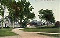
Meadow Road c. 1909
-
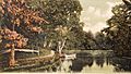
Jordan River in 1906
-
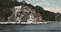
Frye's Leap c. 1905


See also
 In Spanish: Raymond (Maine) para niños
