
New Gloucester, Maine facts for kids
Quick facts for kids
New Gloucester, Maine
|
|
|---|---|

Sabbathday Lake Shaker Village
|
|
| Motto(s):
"Home of the Shaker Community"
|
|

Location in Cumberland County and the state of Maine.
|
|
| Country | United States |
| State | Maine |
| County | Cumberland |
| Incorporated | 1774 |
| Villages | New Gloucester Shaker Village Upper Gloucester |
| Area | |
| • Total | 47.80 sq mi (123.80 km2) |
| • Land | 47.12 sq mi (122.04 km2) |
| • Water | 0.68 sq mi (1.76 km2) |
| Elevation | 449 ft (137 m) |
| Population
(2020)
|
|
| • Total | 5,676 |
| • Density | 120/sq mi (46.5/km2) |
| Time zone | UTC-5 (Eastern (EST)) |
| • Summer (DST) | UTC-4 (EDT) |
| ZIP code |
04260
|
| Area code(s) | 207 |
| FIPS code | 23-48820 |
| GNIS feature ID | 0582619 |
New Gloucester is a town in Cumberland County, Maine, in the United States. It is part of the larger Lewiston-Auburn area. New Gloucester is famous for being home to the Sabbathday Lake Shaker Village. This is the very last active Shaker village in the entire U.S. In 2020, about 5,676 people lived in New Gloucester.
Contents
History of New Gloucester
New Gloucester was first started thanks to a special permission from the Massachusetts Bay Colony. In 1736, the government of Massachusetts gave a piece of land, about 6 square miles (15.5 sq km), in what is now Maine. This land was given to sixty people from the fishing village of Gloucester, Massachusetts.
Early Settlers and Challenges
The first settlers arrived between 1739 and 1742. They built their homes on Harris Hill. However, they had to leave the settlement from 1744 to 1751. This was because of increased attacks during a war called King George's War.
The settlers came back in 1753. They started building a large, two-story fort called a blockhouse. It was 50 feet (15 meters) square and had a strong wooden fence, or palisade, around it. This fort protected twelve families for six years. Men worked on clearing land nearby while soldiers guarded them. There was one attack on the fort. After the attacks stopped, settlers moved into their own homes. The blockhouse was used for meetings and worship until 1773.
Town Incorporation and Growth
New Gloucester officially became a town on March 8, 1774. It was named after Gloucester, Massachusetts, where many of the first settlers came from.
For a while, New Gloucester shared the role of a county seat with Portland. This meant courts met here from 1791 until 1805. The town had good soil for agriculture, so it grew as a successful farming community. By 1858, New Gloucester also had sawmills, gristmills, and tanneries.
Sabbathday Lake Shaker Village
The Sabbathday Lake Shaker Village was founded in 1783. It was formally organized by the Shakers in 1794. Today, this village is the only one left of what used to be nineteen Shaker communities. These communities once stretched from Maine all the way to Florida. The village has 18 buildings and covers about 1,800 acres (7.3 sq km) of land.
-
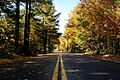
Mayall Road
-
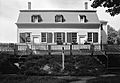
The Shaker Meetinghouse at Sabbathday Lake Shaker Village
-
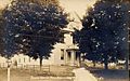
New Gloucester Town Hall around 1915

.jpg)

Geography and Location
New Gloucester covers a total area of about 47.80 square miles (123.80 sq km). Most of this is land, about 47.12 square miles (122.04 sq km). The rest, about 0.68 square miles (1.76 sq km), is water. The Royal River flows through the town.
Transportation Routes
Major roads cross through New Gloucester. These include Interstate 95, U.S. Route 202, and state routes 4, 26, and 231.
Neighboring Towns
New Gloucester shares borders with several other towns:
- Raymond to the west
- Poland to the northwest
- Auburn to the northeast
- Durham to the east
- Pownal and North Yarmouth to the southeast
- Gray to the southwest
Climate in New Gloucester
New Gloucester has a humid continental climate. This means it has big differences in temperature throughout the year. Summers are warm to hot and often humid. Winters are cold, and sometimes very cold. This type of climate is shown as "Dfb" on climate maps.
| Climate data for New Gloucester, Maine | |||||||||||||
|---|---|---|---|---|---|---|---|---|---|---|---|---|---|
| Month | Jan | Feb | Mar | Apr | May | Jun | Jul | Aug | Sep | Oct | Nov | Dec | Year |
| Mean daily maximum °F (°C) | 29.4 (−1.4) |
33.5 (0.8) |
41.9 (5.5) |
53.6 (12.0) |
65.1 (18.4) |
74.0 (23.3) |
79.1 (26.2) |
78.5 (25.8) |
70.0 (21.1) |
58.0 (14.4) |
45.9 (7.7) |
34.8 (1.6) |
54.5 (12.5) |
| Mean daily minimum °F (°C) | 12.6 (−10.8) |
15.9 (−8.9) |
24.0 (−4.4) |
34.9 (1.6) |
44.7 (7.1) |
54.1 (12.3) |
59.7 (15.4) |
58.7 (14.8) |
50.7 (10.4) |
40.1 (4.5) |
31.0 (−0.6) |
19.8 (−6.8) |
37.2 (2.9) |
| Average precipitation inches (mm) | 4.01 (102) |
3.14 (80) |
4.49 (114) |
4.27 (108) |
3.88 (99) |
3.79 (96) |
3.63 (92) |
3.24 (82) |
3.57 (91) |
4.23 (107) |
4.55 (116) |
4.21 (107) |
47.01 (1,194) |
| Average snowfall inches (cm) | 21.2 (54) |
16.5 (42) |
19.9 (51) |
4.8 (12) |
0 (0) |
0 (0) |
0 (0) |
0 (0) |
0 (0) |
0.1 (0.25) |
3.0 (7.6) |
18.3 (46) |
83.8 (213) |
Amenities and Services
New Gloucester has a small, private airport called Cliff Dow Airport. It is located southwest of the town. Its official code is 54ME.
Population and People
| Historical population | |||
|---|---|---|---|
| Census | Pop. | %± | |
| 1790 | 1,358 | — | |
| 1800 | 1,378 | 1.5% | |
| 1810 | 1,649 | 19.7% | |
| 1820 | 1,658 | 0.5% | |
| 1830 | 1,682 | 1.4% | |
| 1840 | 1,946 | 15.7% | |
| 1850 | 1,848 | −5.0% | |
| 1860 | 1,654 | −10.5% | |
| 1870 | 1,496 | −9.6% | |
| 1880 | 1,382 | −7.6% | |
| 1890 | 1,234 | −10.7% | |
| 1900 | 1,162 | −5.8% | |
| 1910 | 1,228 | 5.7% | |
| 1920 | 1,384 | 12.7% | |
| 1930 | 1,866 | 34.8% | |
| 1940 | 2,334 | 25.1% | |
| 1950 | 2,628 | 12.6% | |
| 1960 | 3,047 | 15.9% | |
| 1970 | 2,811 | −7.7% | |
| 1980 | 3,180 | 13.1% | |
| 1990 | 3,916 | 23.1% | |
| 2000 | 4,803 | 22.7% | |
| 2010 | 5,542 | 15.4% | |
| 2020 | 5,676 | 2.4% | |
| sources: | |||
Population in 2010
According to the census in 2010, 5,542 people lived in New Gloucester. There were 2,092 households, which are groups of people living in one home. About 1,534 of these were families. The town had about 117.6 people per square mile (45.4 per sq km).
Most of the people in New Gloucester were White (97.5%). A small number were African American, Native American, or Asian. About 0.8% of the population was Hispanic or Latino.
In 2010, 36.2% of households had children under 18. Most households (59.9%) were married couples living together. The average age of people in the town was 39.5 years old. About 24.5% of residents were under 18.
Arts and Culture
New Gloucester offers several interesting places to visit:
- New Gloucester Historical Society & Museum: Learn about the town's past.
- Sabbathday Lake Shaker Village & Museum: Explore the history and life of the Shakers.
- Royal River Conservation Trust Intervale & Pisgah Hill Preserves: Enjoy nature and hiking trails.
- New Gloucester Veterans Monument: A place to honor veterans.
Education
Students in New Gloucester attend schools within the Maine School Administrative District 15. Other schools in the area include:
- Merriconeag High School
- Collaborative School
- Wayfinder Schools
Notable People from New Gloucester
Many interesting people have come from New Gloucester, including:
- Mildred Barker: A musician and scholar who was also a Shaker Eldress.
- Joseph Brackett: An American songwriter and Shaker Elder.
- Peleg Chandler: A lawyer, journalist, and politician.
- Samuel Fessenden: An abolitionist and lawmaker.
- William Pitt Fessenden: A US congressman and Secretary of the Treasury.
- Sara Plummer Lemmon: A botanist who studied plants in the Western USA. Mount Lemmon in Arizona is named after her.
- Ezekiel Whitman: A US congressman.
See also
 In Spanish: New Gloucester (Maine) para niños
