
Mount Lemmon facts for kids
Quick facts for kids Mount Lemmon |
|
|---|---|

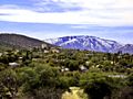
View of Mount Lemmon from the western side of
|
|
| Highest point | |
| Elevation | 9,171 ft (2,795 m) NAVD 88 |
| Prominence | 5,157 ft (1,572 m) |
| Listing | |
| Geography | |

Mount Lemmon
Location in Arizona
|
|
| Location | Tucson, Pima County, Arizona, U.S. |
| Parent range | Santa Catalina Mountains |
| Topo map | USGS Mount Lemmon |
| Climbing | |
| Easiest route | Catalina Highway |
Mount Lemmon is a tall mountain in Arizona, United States. It is the highest point in the Santa Catalina Mountains, reaching about 9,159 feet (2,792 meters) high. You can find it north of Tucson, Arizona, within the Coronado National Forest.
The mountain was named after Sara Plummer Lemmon, a plant expert. She bravely traveled to the top of the mountain in 1881 with her husband and a local rancher named E. O. Stratton. They used horses and walked part of the way. The Tohono O'odham people, who are native to the area, call Mount Lemmon "Babad Do'ag," which means "Frog Mountain."
Contents
Exploring Mount Lemmon's Environment
Mountain Weather and Climate
Mount Lemmon has a unique climate because it is so tall. The very top of the mountain can be 20 to 30 degrees Fahrenheit cooler than its base. This makes it a great place to escape the heat, especially for people living in Tucson during the summer.
During the winter, Mount Lemmon usually gets at least one snowfall. This turns the mountain into a snowy wonderland, which is very popular for visitors.
| Climate data for Mount Lemmon, Arizona (1958–2009) | |||||||||||||
|---|---|---|---|---|---|---|---|---|---|---|---|---|---|
| Month | Jan | Feb | Mar | Apr | May | Jun | Jul | Aug | Sep | Oct | Nov | Dec | Year |
| Record high °F (°C) | 65 (18) |
65 (18) |
68 (20) |
74 (23) |
82 (28) |
91 (33) |
89 (32) |
82 (28) |
81 (27) |
76 (24) |
71 (22) |
65 (18) |
91 (33) |
| Mean daily maximum °F (°C) | 49.2 (9.6) |
48.3 (9.1) |
52.9 (11.6) |
60.8 (16.0) |
69.1 (20.6) |
76.4 (24.7) |
76.5 (24.7) |
73.6 (23.1) |
70.4 (21.3) |
61.7 (16.5) |
56.3 (13.5) |
50.6 (10.3) |
62.2 (16.8) |
| Mean daily minimum °F (°C) | 22.8 (−5.1) |
21.8 (−5.7) |
25.7 (−3.5) |
31.7 (−0.2) |
36.6 (2.6) |
44.4 (6.9) |
49.8 (9.9) |
49.8 (9.9) |
45.1 (7.3) |
36.4 (2.4) |
29.7 (−1.3) |
24.3 (−4.3) |
34.8 (1.6) |
| Record low °F (°C) | −4 (−20) |
−7 (−22) |
−1 (−18) |
19 (−7) |
27 (−3) |
32 (0) |
39 (4) |
42 (6) |
31 (−1) |
20 (−7) |
4 (−16) |
4 (−16) |
−7 (−22) |
| Average precipitation inches (mm) | 3.15 (80) |
1.69 (43) |
1.17 (30) |
0.50 (13) |
0.42 (11) |
0.62 (16) |
4.41 (112) |
7.00 (178) |
3.39 (86) |
3.04 (77) |
2.95 (75) |
2.60 (66) |
30.94 (787) |
| Average snowfall inches (cm) | 16.5 (42) |
20.4 (52) |
6.8 (17) |
2.0 (5.1) |
0 (0) |
0 (0) |
0 (0) |
0 (0) |
0 (0) |
2.0 (5.1) |
6.2 (16) |
11.0 (28) |
64.9 (165) |
| Average precipitation days | 5 | 5 | 5 | 3 | 2 | 2 | 10 | 11 | 5 | 3 | 3 | 5 | 59 |
| Mean monthly sunshine hours | 241 | 243 | 299 | 325 | 374 | 372 | 327 | 319 | 315 | 301 | 260 | 242 | 3,618 |
| Source: Western Region Climate Center | |||||||||||||
Rocks and Formation of Mount Lemmon
Mount Lemmon is made of different types of rock. These include Bolsa Quartzite, Dripping Spring Quartzite, and a mix of sandstone and conglomerate. These rocks have also been cut through by a type of rock called a Diabase Dike. This dike is part of the Apache Group of rocks.
Life on the Mountain
Summerhaven Village

Near the top of Mount Lemmon is a small town called Summerhaven. Many people have summer homes here to enjoy the cooler weather. Some people even live there all year round.
Most of the small cabins in Summerhaven had to be rebuilt. This was after a big forest fire, called the Aspen Fire, happened in July 2003.
Mount Lemmon Observatory
_Mountlemmonobservatory.JPG)
At the very top of Mount Lemmon, you'll find the Mount Lemmon Observatory. This place used to be a radar base for the U.S. Air Force. It even had a special radar station to help the Space Shuttle land safely at White Sands Missile Range.
Now, the United States military no longer uses these facilities. They were given to the United States Forest Service. The University of Arizona now leases the observatory area and buildings from the Forest Service.
Today, the telescopes on the mountain are still used for important space research. Groups like the Catalina Sky Survey and the Mount Lemmon Sky Center use them. The University of Arizona also runs an Astronomy Camp program here. This makes Mount Lemmon a special place for learning and discovering more about space.
Getting Around Mount Lemmon
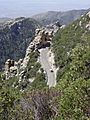
The Scenic Catalina Highway
.jpg)
The Catalina Highway is a beautiful road that goes up the Santa Catalina Mountains. It's also known as the Mount Lemmon Highway or the Hitchcock Highway. The road starts on the east side of Tucson and winds its way up to Summerhaven at the mountain's peak.
This curving road is a favorite for tourists, people from Tucson looking to escape the summer heat, and cyclists. It has recently been named the Sky Island Parkway. This means it's part of the U.S. National Scenic Byway system, recognized for its natural beauty.
In 2010, the first ever Mount Lemmon Marathon was held on this highway.
Fees and Permits for Visitors

If you visit Mount Lemmon, there are some fees for parking, camping, and hiking. However, you only officially pay these fees if you are camping. For other activities like hiking, parking, or grilling, the fees work on an honor system.
Park rangers usually only check for fee payments if someone is using the park's campgrounds. If you are just sightseeing or driving to Summerhaven, you do not need to pay these fees.
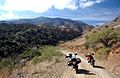
The Backside Road
There's another way to reach the summit of Mount Lemmon, but it's an unpaved road. This road starts in Oracle, which is north of Tucson on Arizona Route 77.
This secondary route is popular with people who like off-road driving in 4x4 vehicles or on special motorcycles. This unpaved road eventually connects with the Catalina Highway near Loma Linda. Before the Catalina Highway was built, this "backside" road was the only way to get up the mountain.
Images for kids
-
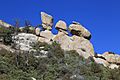
Hoodoos, Santa Catalina Mountains
-
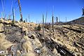
Remnants of the 2003 Aspen Fire
-
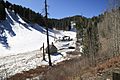
Mount Lemmon Ski Valley
-
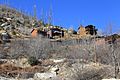
Cabins atop Mt Lemmon in Summerhaven
-
View of Mount Lemmon from Oracle, AZ
-
Unpaved road on the north or "backside" of Mount Lemmon
-
Catalina Highway climbing Mount Lemmon
-

Stereograph of the Mt Lemmon Highway near Windy Point Vista.


