
Santa Catalina Mountains facts for kids
Quick facts for kids Santa Catalina Mountains |
|
|---|---|

Santa Catalina Mountains seen from the east side of the city of Tucson, Arizona
|
|
| Highest point | |
| Peak | Mount Lemmon (N of Summerhaven) |
| Elevation | 9,157 ft (2,791 m) |
| Dimensions | |
| Length | 18 mi (29 km) E-W |
| Width | 14 mi (23 km) |
| Geography | |
| Location | Madrean Sky Islands |
| Country | United States |
| Communities | Tucson, Oro Valley, Catalina, Catalina Foothills, Tanque Verde, Summerhaven and Oracle |
| Geology | |
| Age of rock | Laramide Igneous Rock and Precambrian |
| Type of rock | Intrusive igneous rock (granite) |
The Santa Catalina Mountains, often called the Catalina Mountains or the Catalinas, are a mountain range in Arizona, United States. They are located just north and northeast of the city of Tucson. These mountains are the most noticeable range in the Tucson area. They also have the highest average elevation.
The highest point in the Catalinas is Mount Lemmon. It stands tall at 9,157 feet (2,791 m) above sea level. This peak gets about 18 inches (46 cm) of rain and snow each year.
The Tohono O'odham Nation originally called these mountains Babad Do'ag. Later, in 1697, an Italian Jesuit priest named Eusebio Francisco Kino gave them their current name. He named them after St. Catherine, who was a special saint for his oldest sister.
The Catalinas are part of the Santa Catalina Ranger District. This district is found within the Coronado National Forest. The mountains also include the Pusch Ridge Wilderness Area. The range is known as a "sky island". This means it's a tall, cool mountain area surrounded by hot, dry desert.
Contents
Exploring the Catalinas: Fun Activities and Nature
The Catalinas are a great place for outdoor fun. Many people visit areas like Sabino Canyon. Here, you can find streams and pools of water all year round. It's also a popular spot for dayhiking.
Catalina State Park is located at the western base of the mountains. Visitors love to hike here and see the permanent pools in Romero Canyon. The small village of Summerhaven is on Mount Lemmon. It's a popular place to escape the desert heat in summer.
You can even go skiing at Mount Lemmon Ski Valley. It's special because it's the southernmost ski area in the United States! Other mountain ranges near Tucson include the Santa Rita Mountains, Rincon Mountains, Tucson Mountains, and Tortolita Mountains.
Discovering Space: Catalina Sky Survey
The Catalina Sky Survey (CSS) is located on Mount Lemmon. This project uses telescopes to find comets and asteroids. Its main goal is to search for near-Earth objects (NEOs). These are space rocks that come close to Earth.
CSS specifically looks for any dangerous asteroids. These are called potentially hazardous asteroids. They could possibly hit Earth, so finding them helps us stay safe.
How the Santa Catalina Mountains Got Their Name
The Catalinas were first called "Sierra de las Santa Catarina." This name appeared on old maps from 1864 and 1875. A map from 1890 still used "Santa Catarina Mountains."
However, by 1895, maps started showing the name "Santa Catalina." Over time, between 1890 and 1902, the name changed to the "Santa Catalina Mountains." In 1902, the General Land Office officially named the area the Santa Catalina Forest Reserve. This reserve later became the Santa Catalina National Forest. All these names, "Santa Catarina" and "Santa Catalina," honor St. Catherine.
Protecting the Mountains: National Forest History
After the Gadsden Purchase, more Americans moved into the Arizona Territory. Starting in the 1850s, they looked for gold, silver, and copper in the Catalinas.
By the late 1880s, people living in southern Arizona wanted to protect these mountains. So, the U.S. Congress passed a law. This law allowed the President to set aside certain lands as forest reserves.
The Santa Catalina Forest Reserve was created on July 2, 1902. Then, in 1905, the National Forest Service was formed. The reserve became the Santa Catalina National Forest on March 4, 1907. Finally, on July 1, 1908, it joined with two other nearby forests. Together, they formed the Coronado National Forest we know today.

Cool Places to See in the Catalinas
Mountains and Ridges
- Cathedral Rock
- Mount Bigelow
- Mount Kimball
- Mount Lemmon: This is the highest point!
- Pusch Ridge: The westernmost part of the range.
- Rattlesnake Peak
- Table Mountain
- Thimble Peak
- Window Peak
Canyons to Explore
- Bear Canyon
- Box Camp Canyon
- Canyon del Oro: North of Mount Lemmon.
- Esperero Canyon
- Molino Canyon
- Pima Canyon: Southeast of Pusch Ridge.
- Romero Canyon: Found in Catalina State Park.
- Sabino Canyon
- Ventana Canyon
Other Interesting Spots
- Arizona Trail
- Rose Canyon Lake
- Catalina Highway
- Catalina State Park
- Pusch Ridge Wilderness Area
- Redington Pass
- Summerhaven
- Tanque Verde Falls
- Peppersauce Cave
Fun Facts About the Catalinas
- Mount Lemmon is not the tallest mountain in the Tucson area. Mount Wrightson in the nearby Santa Rita Mountains is taller, at 9,453 feet (2,881 m).
- A type of moth called an owlet moth was first discovered here.
- Mount Lemmon is named after Sara Plummer Lemmon. She was a plant collector and the first white woman to climb the peak in 1881.
- Mercer Spring, near the Molino Basin Campground, is named after rancher Dell Mercer. He once had a ranch in that area.
- Sollers Road, Sollers Point, and Sollers Cabin on Mount Lemmon are named for Carl Sollers. He was a forest ranger who died while working.
- Barnum Rock is a large rock formation near San Pedro Vista. It was once used to spot fires and is now popular for rock climbing. It's named after Willis E. Barnum Sr., a former Boy Scout leader.
Gallery
-
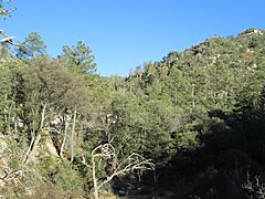
Pine forest in the Santa Catalina Mountains
-
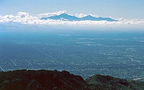
View of "sky islands" from the Catalinas
-
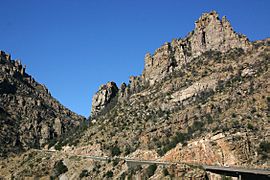
Catalina Highway in the Santa Catalina Mountains
-
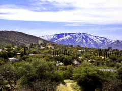
Southern view of Mt. Lemmon from Oracle, Arizona
-
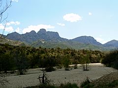
Northwestern view of the Catalina Mountains as seen from Catalina State Park in Oro Valley
-
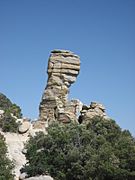
Hitchcock Pinnacle, a hoodoo along Catalina Highway
-
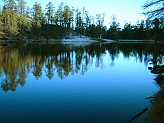
Rose Canyon Lake


See also
 In Spanish: Sierra de Santa Catalina para niños
