
Pima Canyon facts for kids
Quick facts for kids Pima Canyon |
|
|---|---|

Pima Canyon
|
|

Pima Canyon
Location in Arizona
|
|
| Floor elevation | 2,900 feet (884 m) to 6,350 feet (1,935 m) |
| Length | 5 miles (8.0 km) |
| Geography | |
Pima Canyon is a cool canyon found in the Santa Catalina Mountains in Arizona, USA. It's located just north of Tucson, Arizona. One side of the canyon has huge cliffs called Pusch Ridge, which rise sharply from Pima Creek below. The canyon's height changes a lot, from about 2,900 feet (884 meters) at Pima Creek to 6,350 feet (1,935 meters) at a spot called Pima Saddle. The tallest mountain nearby is Mount Kimball.
Contents
Exploring Pima Canyon
Pima Creek, which runs through the canyon, starts below Pima Saddle. The creek doesn't flow all the time; it usually appears after heavy rain or when snow melts in the Santa Catalina Mountains.
Wildlife and Plants
Pima Canyon is a special place called a desert riparian habitat. This means it's a desert area with water, which makes it great for spotting birds. You can also see many desert animals here, like jackrabbits, javelina (which look like wild pigs), and desert bighorn sheep.
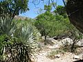
Many cool desert plants grow along the trails. Look for the tall, spiky ocotillo, the flat-padded prickly pear cactus, and the green-barked palo verde trees. You'll also see mesquite trees and the very famous saguaro cacti, which are huge and iconic.
Because Pima Canyon is close to the city of Tucson, it can get quite busy, especially during the mild winter months when the weather is perfect for hiking.
Hiking the Pima Canyon Trail
The Pima Canyon Trail is a popular path for hikers. It's known as Trail #62. The trailhead, which is where the hike begins, is named Iris O. Dewhirst.
Getting to the Trailhead
To reach the Pima Canyon trailhead from Oro Valley, you can drive east on Magee Road from Oracle Road (Arizona Highway 77) until the road ends. If you're coming from Ina Road, take Christie Drive north until it meets Magee Road, then turn right.
Lower Section of the Trail
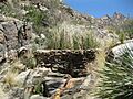
The first part of the trail, from the trailhead to the lower dam, is about 3.2 miles (5.1 kilometers) long. The lowest point at the start is around 2,900 feet (884 meters), and it goes up to about 3,750 feet (1,143 meters) at the dam. This section is considered an "easy hike" and is very popular.
A round trip to the lower dam and back is about 6.4 miles (10.3 kilometers). It can take around two and a half to three hours or more to complete. The US Forest Service manages this area and does not allow dogs or motorized vehicles on the trail.

From the parking lot, the trail heads east into the canyon. You'll see signs reminding you to stay on the path because there's private land nearby. After a short walk, you'll see a metal sign pointing left towards Mount Kimball, which is 7 miles away. Follow this sign. Soon, you'll be deep inside the canyon with tall rock walls on both sides.
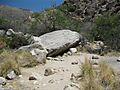
About 45 minutes into the hike, you'll reach an area with some cottonwood trees. Another 30 to 40 minutes will bring you to a small dam. Near the dam, you can find cool potholes in the rocks. People believe these were used by Native Americans for grinding things a long time ago.
Beyond the Dam
From the dam, it's about 2 miles (3.2 kilometers) to Pima Spring. This part of the trail gets steeper and more challenging. A round trip hike to Pima Spring is a good "day hike" if you don't want to go all the way to Mount Kimball.
The trail from Pima Spring to Mount Kimball is very steep and can be hard to follow. There's a metal sign that points to Pima Saddle, which is at the top of Pusch Ridge. Hiking to Pima Saddle and back can take eight hours or even longer!
From Pima Saddle, the trail becomes less clear, so hikers need to look for small piles of rocks called cairns that mark the way. The view from Mount Kimball is amazing! The total round trip from the trailhead to Mount Kimball is about 14.2 miles (22.8 kilometers), and you'll climb about 4,500 feet (1,372 meters) in elevation. Near Mount Kimball, the Pima Canyon Trail (#62) connects with the Finger Rock Trail (#42).
Notable Peaks Along the Trail
As you hike, you'll see several impressive peaks. On the southeast side of the canyon, you might spot Rosewood Point (4,300 feet or 1,311 meters), Prominent Point (6,700 feet or 2,042 meters), and Mount Kimball (7,255 feet or 2,211 meters). On the northwest side, look for Pusch Peak (5,362 feet or 1,634 meters), Bighorn Mountain (5,600 feet or 1,707 meters), Table Mountain (6,200 feet or 1,890 meters), and a rock formation called the Wolf's Teeth.
Images for kids
-
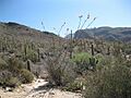
Approach to Pima Canyon
-
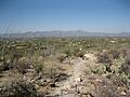
Tucson Range from Pima Canyon
-
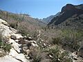
Mouth of Pima Canyon
-
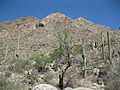
Pusch Peak from Pima Canyon
-
First Trail Crossing of Pima Wash
-
Fourth Trail Crossing of Pima Wash
-
Lower dam in Pima Canyon
-
Gila Monster near trail


