Pusch Ridge facts for kids
Quick facts for kids Pusch Ridge |
|
|---|---|

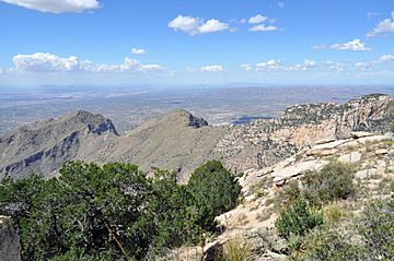
Pusch Ridge from the western summit of Prominent Point
|
|
| Highest point | |
| Peak | Pusch Peak |
| Elevation | 5,366 ft (1,636 m) NAVD 88 |
| Prominence | 841 ft (256 m) |
| Geography | |
| Location | Tucson, Pima County, Arizona, U.S. |
| Parent range | Santa Catalina Mountains |
| Topo map | USGS Tucson North |
Pusch Ridge is a very noticeable mountain ridge in the Santa Catalina Mountains in Arizona. It is located north of Tucson and is part of the Pusch Ridge Wilderness Area. The Coronado National Forest helps manage and protect this special place.
Contents
History of Pusch Ridge
Pusch Ridge is named after a pioneer named George Pusch. He came to Arizona from Germany in the 1870s. In 1874, he started a large cattle ranch called Steam Pump Ranch. This ranch was located near the base of the ridge. Today, this area is the town of Oro Valley.
George Pusch was also important in Arizona's government. He served as a state legislator, helping to make laws for the area. He was also one of the people who helped write Arizona's first constitution in 1910. This document set up how the state would be governed.
Exploring the Peaks of Pusch Ridge
Pusch Ridge has three main peaks that stand out. These peaks are Pusch Peak, Bighorn Mountain, and Table Mountain. They stretch from the southwest to the northeast.
Pusch Peak is the westernmost point of the Santa Catalina Mountains. It rises more than 2,000 feet from its base. Its highest point is 5,366 feet above sea level. Bighorn Mountain reaches an elevation of about 5,662 feet. Table Mountain is the tallest of the three, rising to 6,265 feet. There is also a smaller peak called The Cleaver. It is located between Pusch Peak and Bighorn Mountain. The Cleaver reaches a height of about 4,912 feet.
Wildlife and Nature
Pusch Ridge used to be home to Desert bighorn sheep. These are a special type of wild sheep. Sadly, no bighorn sheep have been seen there since 2005. To help them return, 31 bighorn sheep were released near Pusch Ridge in 2013. This was part of a plan to bring about 100 sheep back to the area.
Pusch Ridge is known for its dramatic ridges and deep canyons. It also has many different types of plants and animals. This is because the elevation changes a lot across the ridge. From Pusch Ridge, you can see amazing views of Oro Valley to the west. You can also see the city of Tucson to the south.
On June 5, 2020, lightning from a thunderstorm started a brush fire on Bighorn Peak. This fire burned about 40 acres in just 12 hours. Helicopters were used to drop water on the fire. This fire, known as the Bighorn Fire, grew very large. It became one of the biggest wildfires in Arizona's history.
Pusch Ridge Trailhead
The Pusch Ridge Trailhead is a starting point for hiking trails. It is located in Oro Valley. You can reach it from East Linda Vista Boulevard. This road is just east of North Oracle Road (State Route 77). The trailhead is about six miles north of Tucson.
Sometimes, there are rules about hiking on Pusch Ridge. These rules are in place to protect the bighorn sheep. They help make sure the sheep can breed without being disturbed.
 | Lonnie Johnson |
 | Granville Woods |
 | Lewis Howard Latimer |
 | James West |

