Catalina Highway facts for kids
Quick facts for kids
Catalina Highway |
|
|---|---|
| General Hitchcock Highway, Sky Island Scenic Byway, Mt Lemmon Highway | |
|
Catalina Highway highlighted in red
|
|
| Route information | |
| Maintained by US Forest Service | |
| Length | 27 mi (43 km) |
| Existed | 1933–present |
| Tourist routes |
|
| Major junctions | |
| South end | Tanque Verde Road in Tucson |
| North end | Near the summit of Mount Lemmon |
| Location | |
| Counties: | Pima, Arizona |
| Highway system | |
| State routes in Arizona Unconstructed • Former |
|
The Catalina Highway is a famous road in southern Arizona. It's also known as the General Hitchcock Highway or the Sky Island Scenic Byway. This special road is the only paved way to reach the mountain village of Summerhaven. It also leads to fun places and science centers near the top of Mount Lemmon.
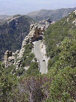
This highway starts in the desert near Tucson. It then climbs over 6,000 feet (about 1,800 meters) to reach cool, high forests. It's like going from Mexico to Canada in just 27 miles! This amazing change in climate is why the mountains are called "sky islands." They are like green islands in a big desert sea. The road is officially recognized as a beautiful scenic byway.
Contents
Exploring the Catalina Highway
The Catalina Highway begins in northeast Tucson. It passes through a community called Tanque Verde. Soon after, it enters the Coronado National Forest. Here, the road officially becomes the General Hitchcock Highway. However, many people still call the whole road the Catalina Highway.
From the forest boundary, the highway twists and turns through the Santa Catalina Mountains. It goes through a place called Molino Canyon. The road climbs quickly, so there are many sharp turns, called switchbacks. It generally heads north, passing Rose Canyon Lake. Then it turns northwest, going past Whitetail and Soldier Camp. Finally, it reaches the village of Summerhaven.
The last part of the road is sometimes called Ski Run Road. It goes east to the Mount Lemmon Ski Valley. The highway ends near the very top of Mount Lemmon.
A Look at the Highway's Past
Building the Catalina Highway started in 1933. A man named Frank Harris Hitchcock helped make it happen. He wanted a better road to the popular spots on Mount Lemmon. A special camp was set up to provide workers for the road.
During World War II, this camp became a place for people of Japanese American descent. They also helped build the highway. One of these individuals, Gordon Hirabayashi, was honored later. In 1999, the camp site became the Gordon Hirabayashi Recreation Area.
The highway took a long time to build. It was finally finished in 1950, 17 years after it began. The road was named after Frank Hitchcock, who had passed away in 1935.
For many years, the road was narrow and bumpy. It was known for being quite challenging to drive. But starting in 1988, big improvements began. These projects made the road wider and safer. They added guard rails and better shoulders. The goal was to make it safer without harming the beautiful mountain views. The last of these projects finished in 2007. The highway is now much safer and smoother for everyone.
Fun Things to Do on the Highway
The Catalina Highway is the only paved way to reach the attractions on Mount Lemmon. It's a very popular place for visitors. More than a million people travel this highway every year!
There are many fun things to do in the Coronado National Forest. You can find campgrounds and picnic spots. There are also trails for hiking and biking. The views along the way are amazing.
At the top of the highway is the Mount Lemmon Ski Valley. It's the southernmost ski resort in the continental United States. You can ski there in winter. In summer, you can take "sky rides" on the ski lift for great views.
The drive itself is a big attraction. The Forest Service says it's like taking a trip from Mexico to Canada in just 27 miles. You'll see many different plants along the way. These include saguaro cacti and mesquite trees in the desert. Higher up, you'll find oak, juniper, and pinyon pine trees. Even higher, you'll see pine forests. Finally, at the top, there are fir and aspen trees in the cooler areas.
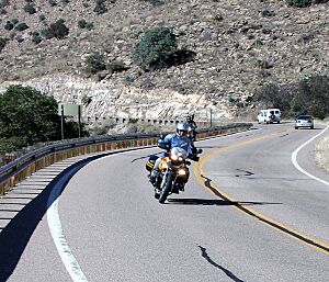
The beautiful views and winding roads make it a favorite for motorcyclists. It's also a big challenge for bicyclists. Many groups organize rides up the mountain. In October 2010, the first Mount Lemmon Marathon took place. Nearly 800 runners finished the race up to Summerhaven.
Road Connections
The entire route is in Pima County.
| Location | Mile | Roads intersected | Notes | |
|---|---|---|---|---|
| Tucson | 0.0 | 0.0 | Tanque Verde Road | This is where the highway starts in the south. |
| Harrison Road | ||||
| Prince Road | ||||
| Houghton Road | ||||
| Snyder Road | ||||
| | 27.0 | 43.5 | Dead end near Mt. Lemmon | This is where the highway ends in the north, near the mountain top. |
| 1.000 mi = 1.609 km; 1.000 km = 0.621 mi | ||||
 | May Edward Chinn |
 | Rebecca Cole |
 | Alexa Canady |
 | Dorothy Lavinia Brown |


