
Pima, Arizona facts for kids
Quick facts for kids
Pima, Arizona
|
||
|---|---|---|

Downtown Pima
|
||
|
||
| Motto(s):
"Pioneers of the Valley"
|
||

Location of Pima in Graham County, Arizona.
|
||

Pima, Arizona
Location in the United States
|
||
| Country | United States | |
| State | Arizona | |
| County | Graham | |
| Area | ||
| • Total | 7.36 sq mi (19.05 km2) | |
| • Land | 7.30 sq mi (18.90 km2) | |
| • Water | 0.06 sq mi (0.16 km2) | |
| Elevation | 2,881 ft (878 m) | |
| Population
(2020)
|
||
| • Total | 2,847 | |
| • Density | 390.21/sq mi (150.67/km2) | |
| Time zone | UTC-7 (MST (no DST)) | |
| ZIP codes |
85535, 85543
|
|
| Area code(s) | 928 | |
| FIPS code | 04-55560 | |
| GNIS feature ID | 2413130 | |

Pima is a small town located in Graham County, Arizona, in the United States. In 2020, about 2,847 people lived there. Pima is part of the larger Safford area.
Even though its name sounds like Pima County, Pima is not located in that county.
Contents
History of Pima
Early Settlers and Name Change
Pima was first settled in 1879 by a group of Mormon pioneers. They originally called the settlement "Smithville." These first settlers had to move from another place called Forrest Dale because it was on Native American land. Unlike some other Mormon settlements, Smithville was not planned by the church leaders.
Growth of the Community
A man named Joseph K. Rogers was the first leader of the Mormon branch in Pima. He was chosen even before the settlers arrived. The branch became a larger group called a "ward" in 1880. By 1930, the ward had 666 members, and Pima itself had a population of 980 people. By 1990, the town's population grew to 1,725 residents.
The Mormon Temple Connection
In 1882, a leader named Jesse N. Smith predicted that a Mormon temple would one day be built near Pima. Today, the Gila Valley Arizona Temple stands between Pima and Thatcher. It is located within the area served by the Pima Arizona Stake of the Church.
Geography and Location
Where is Pima Located?
Pima is found in the middle of Graham County, in the valley of the Gila River. U.S. Route 70 runs through the town. This road leads southeast about 8 miles (13 km) to Safford, which is the main city of the county. If you go northwest on the same road, you'll reach Globe, about 68 miles (109 km) away.
Land and Water Area
The town of Pima covers a total area of about 15.4 square kilometers (5.9 square miles). Most of this area is land. Only a small part, about 0.1 square kilometers (0.04 square miles), is water.
Population Changes Over Time
| Historical population | |||
|---|---|---|---|
| Census | Pop. | %± | |
| 1890 | 750 | — | |
| 1900 | 521 | −30.5% | |
| 1910 | 500 | −4.0% | |
| 1920 | 515 | 3.0% | |
| 1930 | 980 | 90.3% | |
| 1940 | 867 | −11.5% | |
| 1950 | 824 | −5.0% | |
| 1960 | 806 | −2.2% | |
| 1970 | 1,184 | 46.9% | |
| 1980 | 1,599 | 35.1% | |
| 1990 | 1,725 | 7.9% | |
| 2000 | 1,989 | 15.3% | |
| 2010 | 2,387 | 20.0% | |
| 2020 | 2,847 | 19.3% | |
| U.S. Decennial Census | |||
The population of Pima has changed quite a bit over the years. In 1890, there were 750 people. The population went down for a while, but then started to grow steadily. By 2020, the number of people living in Pima reached 2,847.
Who Lives in Pima?
In 2000, there were 1,989 people living in Pima. Most residents were White. About 20% of the population identified as Hispanic or Latino.
Many households in Pima had children under 18 living with them. The average household had about three people. The town's population included a mix of age groups, with a good number of young people and also older adults. The median age was 30 years old.
Historic Buildings Gallery
- Historic Buildings
-
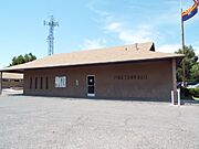
Pima Town Hall
-
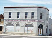
Former Bank of Pima building
-
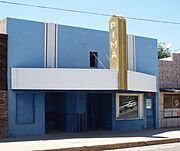
Pima Theater built in 1930


Getting Around Pima
San Carlos Apache Nnee Bich'o Nii Transit provides bus services in the area. You can use this transportation to travel from Pima to the San Carlos Apache Indian Reservation, Safford, and Globe.
See also
 In Spanish: Pima (Arizona) para niños
