Rincon Mountains facts for kids
Quick facts for kids Rincon Mountains |
|
|---|---|

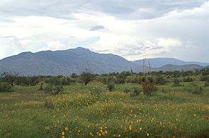
View to north toward Rincon Peak from Mescal Road. Mica Mountain to rear at right.
|
|
| Highest point | |
| Peak | Mica Mountain |
| Elevation | 8,664 ft (2,641 m) |
| Dimensions | |
| Length | 33 mi (53 km) SW x NE |
| Width | 28 mi (45 km) |
| Geography | |
| Country | United States |
| Settlement | Tucson |
| Range coordinates | 32°10′26″N 110°30′40″W / 32.174°N 110.511°W |
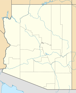
The Rincon Mountains are a cool mountain range in Arizona, located just east of the city of Tucson. In the O'odham language, they are called Cew Doʼag.
These mountains are one of five big ranges that surround the Tucson valley. The other ranges include the Santa Catalina Mountains to the north and the Santa Rita Mountains to the south. You can also find the Tucson Mountains to the west and the Tortolita Mountains to the northwest.
Redington Pass is a mountain pass that separates the Rincon Mountains from the Santa Catalina Mountains. The Rincon Mountains are generally not as rough or steep as the Santa Catalina or Santa Rita Mountains. They are also part of the Madrean Sky Islands, which are like "island" mountains in the desert.
The name Rincón comes from the Spanish word for corner. This name fits because the mountain range has a corner shape. Mica Mountain is the highest point at 8,664 feet (2,641 meters). It forms the top of the corner.
Rincon Peak (8,482 feet) makes up the southern part of the corner. Tanque Verde Peak (7,049 feet) forms the western part. The area inside this corner is called Rincon Valley. This valley used to be mostly ranchland. Now, many new homes are being built there.
On the east side of Rincon Valley, near the town of Vail, you can find Colossal Cave County Park. It is a limestone cave and a popular place to visit.
East of the Rincon Mountains are the Little Rincon Mountains. Between these two ranges is Happy Valley. This area is popular for camping, hunting, and off-roading. Even further east is the San Pedro River and its valley. This area is known for finding ancient animal fossils.
South of the Rincon Mountains, past Rincon Valley, are Cienega Creek and Interstate 10. Most of the Rincon Mountains are protected areas. They are either part of Saguaro National Park or the Rincon Mountain Wilderness. This wilderness area is part of the Coronado National Forest.
Contents
Exploring the Rincon Mountains
Most of the Rincon Mountains are protected, so you cannot use motorized vehicles or bicycles there. However, you can explore the mountains on foot or by horseback.
Trails on the East Side
- Turkey Creek Trail
- Miller Creek Trail
Trails on the North Side
- Italian Ranch (Italian Springs) Trail
- Espiritu Creek Trail (This trail is hard to use because of thick plants.)
Trails on the West Side
- Douglas Springs Trail
- Tanque Verde Ridge Trail
Trails on the South Side
- Madrona/Rincon Peak Trail (You cannot reach this trail because its starting point is on private land.)
The Arizona Trail is a long trail that goes through the Rincon Mountains. It enters from the north using the Italian Ranch trail. It then goes southeast using the Miller Creek Trail.
See also
 In Spanish: Sierra del Rincón (Arizona) para niños
 | George Robert Carruthers |
 | Patricia Bath |
 | Jan Ernst Matzeliger |
 | Alexander Miles |


