
Saguaro National Park facts for kids
Quick facts for kids Saguaro National Park |
|
|---|---|
|
IUCN Category II (National Park)
|
|

Sunset in the Rincon Mountain District of the park
|
|

Saguaro National Park
Location in Arizona
|
|
| Location | Tucson, Arizona, Pima, Arizona, United States |
| Area | 91,716 acres (371.16 km2) |
| Established | October 14, 1994 |
| Named for | Saguaro, a cactus |
| Visitors | 957,405 (in 2018) |
| Governing body | National Park Service |
| Website | Saguaro National Park |
Saguaro National Park is a special place in Pima County, southeastern Arizona, in the United States. It covers about 92,000 acres (37,000 hectares). The park is split into two parts. One part, the Tucson Mountain District (TMD), is west of Tucson. The other, the Rincon Mountain District (RMD), is east of the city. Both areas protect the unique plants and animals of the Sonoran Desert, especially the huge saguaro cactus.
The rocks in the Tucson Mountain District are different from those in the Rincon Mountain District. Over millions of years, the Earth's crust stretched and moved rocks. This created the Rincon Mountains from rocks that were once under the Tucson Mountains. The Rincon Mountains are taller and get more rain than the Tucson Mountains. They are part of the Madrean Sky Islands. These "sky islands" are like tall, green islands in a sea of desert. They have many different kinds of plants and animals. Some of these species are not found in the Tucson Mountain District.
Long ago, people like the Hohokam, Sobaipuri, Tohono O'odham, and Apache lived here. Later, Spanish explorers, missionaries, miners, and ranchers came. In 1933, President Herbert Hoover made the Rincon Mountains area a national monument. It was called Saguaro National Monument. In 1961, President John F. Kennedy added the Tucson Mountain District to the monument. He also renamed the original area the Rincon Mountain District. Finally, in 1994, the Congress made both districts into Saguaro National Park.
Many people visit the park to hike on its 165 miles (266 km) of trails. They also enjoy driving along the paved roads near the two visitor centers. You can ride bikes and horses on some roads and trails in both districts. The Rincon Mountain District offers some wilderness camping. However, you cannot camp overnight in the Tucson Mountain District.
Contents
What's in a Name?
_at_Saguaro_National_Park.jpg)
The park is named after the saguaro (Carnegiea gigantea). This is a very large cactus that only grows naturally in the Sonoran Desert. The word Rincón is Spanish for corner. It describes the shape of the Rincon Mountains. The name Tucson comes from Papago-Piman words. These words mean dark spring or brown spring. Tank or Tanque means a small pool of water. This water collects behind a dam in a natural dip in the ground. Madrean comes from Madre in Sierra Madre, which means Mother Mountains.
Park Location and Size
Saguaro National Park has two separate parts. The Tucson Mountain District (TMD) is west of Tucson, Arizona. The Rincon Mountain District (RMD) is east of Tucson. Both parts are about 10 miles (16 km) from the center of the city. In 2016, the park's total area was 91,716 acres (37,116 hectares). The Tucson Mountain District is about 25,000 acres (10,000 hectares). The Rincon Mountain District is much larger, at about 67,000 acres (27,000 hectares). About 71,000 acres (29,000 hectares) of the park is protected as wilderness. This means it is kept as natural as possible.
Interstate 10, a major highway, goes through Tucson. Tucson Mountain Park is next to the south side of the Tucson Mountain District. The Avra Valley is to its west. The Rincon Mountain Wilderness is a separate protected area. It is part of the Coronado National Forest. This wilderness area is next to the Rincon Mountain District on the east.
Both districts protect parts of the Sonoran Desert. This includes hills like the Tucson Mountains in the west and the Rincon Mountains in the east. In the Tucson Mountain District, the land ranges from 2,180 to 4,687 feet (664 to 1,429 m) high. The highest point is Wasson Peak. In the Rincon Mountain District, elevations go from 2,670 to 8,666 feet (814 to 2,641 m). The highest point here is Mica Mountain.
The park is in the area where water flows into the Santa Cruz River. This river usually has no water. Rincon Creek, in the southern Rincon Mountain District, flows for part of the year. It has the largest green area (riparian zone) in the park. The washes (dry streambeds) in both districts are usually dry. But they can have sudden floods after heavy rain.
Park Weather
Saguaro National Park has a hot, semi-dry climate. This means it's usually warm with not much rain. In the summer, short, strong rains can happen. These often come with lightning, dust storms, and flash floods. At the highest parts of the Rincon Mountains, snow falls in winter. This melting snow adds to the small amount of water available later in the year.
Studies show that the park's average yearly temperature has gone up by about 4°F (2.2°C) from 1900 to 2010. This is due to climate change.
Park Rocks and Land

The oldest rocks in Saguaro National Park are called Pinal Schist. They are about 1.7 billion years old. You can see this schist in the Rincon Mountain District. Other old rocks, 1.4-billion-year-old granites, make up much of Tanque Verde Ridge.
Much later, about 600 million years ago, shallow seas covered this area. Over time, these seas left behind sedimentary rocks like limestones, sandstones, and shales. Limestone was mined here in the late 1800s to make mortar. The park land once had six lime kilns (ovens for making lime). You can still visit three of them in the Rincon Mountain District.
About 80 million years ago, Earth's tectonic plates moved. This caused mountains to form. Explosive volcanoes created the Tucson Mountains about 70 million years ago. The top of the volcano collapsed, forming a large crater called a caldera. Volcanic rocks in the Tucson Mountain District are what's left of these events.
The Tucson Basin and nearby mountains are part of the Basin and Range Province. This area formed when the Earth's crust stretched and pulled apart. Rocks from deep under the Tucson Mountains were pushed up. They formed the Santa Catalina and Rincon mountains we see today. The most common rock in the Rincon Mountains is a banded rock called Catalina gneiss. You can see it at places like Javelina Rocks.
Park History
Early People and Settlers

The first known people to live in this area were the Hohokam. They lived in villages between 200 and 1450 A.D. You can still find their Petroglyphs (rock carvings) and pottery pieces in the park. The Hohokam hunted animals and gathered wild plants. They also grew corn, beans, and squash. Later groups like the Sobaipuri and Tohono O'odham might be related to the Hohokam.
Spanish explorers first came to Arizona in 1539. But people from other countries didn't settle near the park until 1692. That's when the San Xavier Mission was built. In 1775, the Spanish built a fort in Tucson. This fort helped protect against raids by Apaches.
The land that became Saguaro National Park stayed mostly wild until the mid-1800s. After Arizona became part of the United States, things changed. The Homestead Act of 1862 allowed people to claim land. The railroad arrived in 1880. When the Apache Wars ended in 1886, more homesteaders and ranchers moved in. Miners also looked for silver, copper, and other valuable metals. Mining in the park continued until 1942. Ranching on private land inside the park lasted until the mid-1970s.
The Loma Verde Mine in the Rincon Mountain District produced a little copper and gold. In the Tucson Mountain District, the Copper King Mine was the most successful. It produced copper, gold, and other metals. It closed in 1942.
Ranchers let thousands of cattle graze on public land that later became the park. Homesteaders farmed and ranched at the base of the Rincon Mountains. The remains of the Freeman Homestead, from 1929, are now along a nature trail. Manning Cabin, built in 1905, was a summer home for a wealthy businessman. It is now a historic site. The park has over 450 old archaeological sites and more than 60 historic buildings.
Becoming a National Park

In the 1920s, people from the University of Arizona wanted to protect the saguaro cactus. In 1933, Frank Harris Hitchcock, a newspaper publisher, convinced President Herbert Hoover to create Saguaro National Monument. Hoover used the Antiquities Act to do this on March 1, 1933. Later that year, the National Park Service took over managing the monument. From 1936 to 1939, the Civilian Conservation Corps (CCC) built roads and other things in the park.
In 1961, President John F. Kennedy added 16,000 acres (6,500 hectares) from the Tucson Mountains to the monument. This became the Tucson Mountain District. The original area was renamed the Rincon Mountain District. In 1994, Congress made both districts into Saguaro National Park. In 2021, another 1,232 acres (5 km2) were added to the park.

Plants and Fungi of the Park

The types of plants in the park change with how high up the land is. The Tucson Mountain District has two main plant groups. At the lowest spots, there are desert shrubs like fourwing saltbush and brittlebrush. A little higher up, you find desert grasslands.
The Rincon Mountain District has these two groups, plus four more at higher elevations. These include oak woodlands, pine-oak woodlands, and pine forests. High in the Rincon Mountains, there's a mixed conifer forest. Here you can find Douglas-fir, Ponderosa pine, white fir, and Gambel oak. Scientists have found 389 types of plants with veins (vascular plants), 25 types of plants without veins (non-vascular plants), and 197 types of fungi in the park.
Saguaros grow in both parts of the park. They grow very slowly. A saguaro's first arm usually appears when the cactus is 50 to 70 years old. It might take 100 years in very dry places. Saguaros can live for up to 200 years. They are considered fully grown at about 125 years old. A mature saguaro can be 60 feet (18 m) tall and weigh up to 4,800 pounds (2,200 kg) when full of water. There are about 1.8 million saguaros in the park. Also, 24 other types of cactus are common. These include the fishhook barrel, staghorn cholla, pinkflower hedgehog, Engelman's prickly pear, teddybear cholla, and jumping cholla.
Some plants that are not native to the park are causing problems. One big threat is buffelgrass. This plant came from Africa and Asia. It was planted in the 1930s to feed cattle and stop dirt from washing away. Buffelgrass was first seen in the park in 1989. It spreads quickly and takes water from native plants. It also makes fires much worse. Park staff try to remove it by hand or with special sprays.

Animals of the Park

Scientists have found 30 types of medium and large mammals in Saguaro National Park. Twenty-one of these live in the Tucson Mountain District and 29 in the Rincon Mountain District. Some of the mammals you might see are cougars, coyotes, bobcats, white-tailed deer, mule deer, javelinas, gray foxes, black-tailed jackrabbits, and desert cottontails. An endangered mammal, the lesser long-nosed bat, lives in the park for part of the year.
The park has many different places for birds to live. There are 107 bird species here. Some are rare in other parts of the United States. These include vermilion flycatchers and whiskered screech owls. Other birds you might see are great horned owls, cactus wrens, ravens, kestrels, turkey vultures, roadrunners, and woodpeckers. The Mexican spotted owl is a threatened species in the park.
The park has 36 types of reptiles. These include desert tortoises, diamondback rattlesnakes, coral snakes, Gila monsters, and different kinds of lizards. Even though it's dry, three types of amphibians live here. They are the canyon tree frog, the lowland leopard frog, and Couch's spadefoot. Couch's spadefoot lives in burrows and comes out to breed when it rains in summer. Forest fires can harm the leopard frog's breeding pools.
Human activities like city growth, pollution, and noise affect the park's animals. But the biggest danger to animals is being hit by cars. About 50,000 animals die on the park's roads each year. Picture Rocks Road, which goes through the Tucson Mountain District, is very dangerous for wildlife.
Sky Islands and Biodiversity
The Rincon Mountains and the nearby Santa Catalina Mountains are part of about 40 mountain ranges called the Madrean Sky Islands. These ranges are like stepping stones between the Rocky Mountains in the U.S. and the Sierra Madre Occidental in Mexico. They are "islands" of mountains separated by "seas" of lower desert valleys. These valleys make it harder for species to move between the islands, but not impossible.
These Sky Islands are special because they stretch from north to south across different climate zones. They also have many different kinds of rocks and soils. This helps them have a lot of different plants and animals, which is called biodiversity.
Things to Do in the Park
The park is usually open for hikers every day except Christmas. The Tucson Mountain District is open for cars from sunrise to sunset. The Rincon Mountain District is open from 7 a.m. to sunset. Both districts have visitor centers. When hiking, be careful of extreme heat, not having enough water, flash floods, cactus spines, snakes, cougars, bears, and Africanized bees. You can camp in the wilderness of the Rincon Mountain District with a permit. But no overnight camping is allowed in the Tucson Mountain District.
Tucson Mountain District Activities

The Tucson Mountain District has 12 miles (19 km) of paved roads and 8.5 miles (13.7 km) of unpaved roads. This includes the 5-mile (8 km) Bajada Loop Drive. You can ride bikes only on paved roads, Bajada Loop Drive, Golden Gate Road, and the Belmont multi-use trail. Horses are allowed on some trails.
You can easily see Hohokam petroglyphs (rock carvings) in this district. The Signal Hill Trail leads to an area with many 800-year-old rock art examples.
The Civilian Conservation Corps (CCC) built picnic areas and restrooms here between 1933 and 1941. These buildings are made from local stone and blend into the natural surroundings.
The Arizona-Sonora Desert Museum is just south of the Tucson Mountain District. It's like a botanical garden, zoo, and natural history museum all in one. It shows plants and animals native to the area.
Rincon Mountain District Activities

The Rincon Mountain District has the 8.3-mile (13.4 km) Cactus Forest Loop Drive. This road helps you get to some of the trails. A part of the Arizona Trail crosses this district. This 800-mile (1,300 km) trail goes across Arizona from Mexico to Utah. In 2009, it was named a National Scenic Trail.
You can ride horses on some trails. Horses and burros must carry their own food and cannot eat plants in the park. Bicycling is allowed on the Cactus Forest Loop Drive and two park trails.
Manning Camp Campground is a main spot for firefighters, trail workers, and scientists. Their supplies are brought in by mules. Water from a nearby spring, the largest in the Rincons, provides water for the animals.
Next to the Rincon Mountain District is the Desert Research Learning Center (DRLC). It supports science and education projects for Sonoran Desert parks. The DRLC has desert plants and a rainwater collection system. It is open to the public.
Images for kids
-
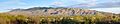
Panorama of the Rincon Mountains. The houses and vegetation in the foreground are in Pima County, a few blocks east of the eastern boundary of Tucson.
See also
 In Spanish: Parque nacional Saguaro para niños
