
Avra Valley facts for kids
Quick facts for kids Avra Valley |
|
|---|---|

view of valley lands
Tucson Mountains, center east valley |
|

Avra Valley
Location in Arizona
|
|
| Length | 45 mi (72 km) |
| Width | 10 mi (16 km) |
| Geography | |
| Country | United States |
| State | Arizona |
| Region | Sonoran Desert |
| Counties | Pima and Pinal |
| Population centers | Marana, Robles Junction and South Tucson |
| Borders on |
List
|
The Avra Valley is a long valley, about 50 miles (80 km) long. It stretches from northwest to southeast. You can find it just west of Tucson, Arizona. The Tucson Mountains are in the middle-east part of the valley. Many towns and communities are located along Interstate 10. This highway runs through the valley and connects to cities like Casa Grande and Phoenix.
In the northeast part of the valley, you'll find Marana. This area is home to the Pinal Airpark, which is a special place where old airplanes are stored. The Avra Valley Airport is also nearby. It's used for smaller planes and for storing classic propeller-era airliners.
The center of the valley, towards the west, is marked by Cocoraque Butte. This small mountain is about 2,758 feet (841 meters) tall. It extends northeast from the Roskruge Mountains.

Contents
Exploring Avra Valley's Landscape
The Avra Valley is quite narrow, only about 10 miles (16 km) wide in some spots. It's surrounded by mountains on its western side. These mountains are not very tall and are quite dry.
Mountains and Borders
Starting from the northwest, you'll see the West Silver Bells, then the Silver Bell Mountains, and the Watermans. Further south, you'll find the Roskruge Mountains.
To the southwest, Arizona Route 86 enters the valley. This road comes from the Tohono Oʼodham Nation, a large Native American reservation. Also in the southwest is Robles Junction, Arizona. From here, you can travel southwest to Sasabe and into the Altar Valley. Robles Junction is also near the northern part of the Sierrita Mountains, which form the southern border of Avra Valley.
The northern part of the Avra Valley gets narrower near the Silver Bell Mountains and Marana. This area then opens up into wider flatlands. These flatlands are part of the Santa Cruz River floodplain, where it eventually joins the Gila River.
Saguaro National Park West
The famous Saguaro National Park has two main sections. One is near Tucson's southeast. The other, smaller section, covers much of the Tucson Mountains right here in Avra Valley. This park is well-known for its giant saguaro cacti, which are very tall and can live for a long time.
San Xavier Mission
In the southeast corner of the Avra Valley, you'll find the historic Mission San Xavier del Bac. This beautiful mission is located within the San Xavier Indian Reservation. This reservation is part of the larger Tohono Oʼodham Nation. The Tohono O'odham people have more lands to the west and southwest, near the Baboquivari Mountains and the Altar Valley.
Images for kids
-
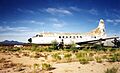
Convair 240, stored at Avra Valley Airport in Avra Valley
-
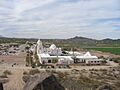
view westward over southern Avra Valley, Mission San Xavier del Bac
,_1996_(6340882).jpg)

