Avra Valley, Arizona facts for kids
Quick facts for kids
Avra Valley, Arizona
|
|
|---|---|

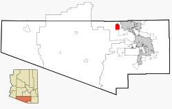
Location in Pima County and the state of Arizona
|
|
| Country | United States |
| State | Arizona |
| County | Pima |
| Area | |
| • Total | 22.37 sq mi (57.95 km2) |
| • Land | 22.37 sq mi (57.95 km2) |
| • Water | 0.00 sq mi (0.00 km2) |
| Elevation | 1,919 ft (585 m) |
| Population
(2020)
|
|
| • Total | 5,569 |
| • Density | 248.90/sq mi (96.10/km2) |
| Time zone | UTC-7 (MST (no daylight saving time)) |
| ZIP code |
85653
|
| Area code(s) | 520 |
| FIPS code | 04-04880 |
| GNIS feature ID | 1866979 |
Avra Valley (which is Ko:jĭ Pi Bak in the O'odham language) is a special kind of community in Pima County, Arizona, United States. It's called a census-designated place (CDP) because it's a community that the government counts for population, but it's not officially a city or town. In 2010, about 6,050 people lived there.
Contents
Where is Avra Valley?
Avra Valley is located in Arizona, at a specific spot on the map: 32.418704 degrees North and -111.328028 degrees West. This means it's in the southwestern part of the United States.
The community covers an area of about 22.1 square miles (about 57.95 square kilometers). All of this area is land, with no large bodies of water.
What's the Weather Like?
Avra Valley has a hot desert climate. This means it gets very hot and dry, especially in the summer.
| Climate data for Avra Valley, Arizona | |||||||||||||
|---|---|---|---|---|---|---|---|---|---|---|---|---|---|
| Month | Jan | Feb | Mar | Apr | May | Jun | Jul | Aug | Sep | Oct | Nov | Dec | Year |
| Record high °F (°C) | 87 (31) |
90 (32) |
97 (36) |
104 (40) |
108 (42) |
115 (46) |
114 (46) |
113 (45) |
109 (43) |
106 (41) |
95 (35) |
88 (31) |
115 (46) |
| Mean daily maximum °F (°C) | 66 (19) |
69 (21) |
75 (24) |
83 (28) |
92 (33) |
101 (38) |
101 (38) |
99 (37) |
96 (36) |
86 (30) |
75 (24) |
66 (19) |
84 (29) |
| Daily mean °F (°C) | 53 (12) |
56 (13) |
61 (16) |
68 (20) |
77 (25) |
85 (29) |
88 (31) |
86 (30) |
82 (28) |
72 (22) |
61 (16) |
53 (12) |
70 (21) |
| Mean daily minimum °F (°C) | 39 (4) |
42 (6) |
46 (8) |
53 (12) |
61 (16) |
69 (21) |
74 (23) |
72 (22) |
68 (20) |
57 (14) |
46 (8) |
39 (4) |
56 (13) |
| Record low °F (°C) | 15 (−9) |
19 (−7) |
26 (−3) |
27 (−3) |
42 (6) |
51 (11) |
51 (11) |
46 (8) |
46 (8) |
35 (2) |
26 (−3) |
21 (−6) |
15 (−9) |
Who Lives in Avra Valley?
| Historical population | |||
|---|---|---|---|
| Census | Pop. | %± | |
| 1990 | 3,403 | — | |
| 2000 | 5,038 | 48.0% | |
| 2010 | 6,050 | 20.1% | |
| 2020 | 5,569 | −8.0% | |
| U.S. Decennial Census | |||
Avra Valley was first counted as a CDP in the 1990 U.S. Census.
In 2000, there were 5,038 people living in Avra Valley. Most people were White (84%), with smaller groups of Black or African American, Native American, and Asian residents. About 20.7% of the people were Hispanic or Latino.
The average age of people living in Avra Valley in 2000 was 34 years old. About 31.5% of the population was under 18 years old.
Schools in Avra Valley
Students in Avra Valley attend schools that are part of the Marana Unified School District.
Farming History in Avra Valley
Farming has been an important part of Avra Valley and the nearby Marana area for a very long time.
- Early Farmers: The Anway family arrived in 1919 and began to buy land for farming and raising animals. Later, another family named Manville also settled there and started farming. Today, you can find main roads in Avra Valley named after both the Anway and Manville families.
- Modern Farms:
- Burruel and Burruel: This is a local farm in Avra Valley, managed by Arnoldo Burruel.
- Bayer Greenhouse: This is a special facility run by the company Bayer. Here, scientists are working to find ways to help corn plants grow better in different weather conditions around the world.
Other Important Places
- Marana Regional Airport: This airport is located in Avra Valley. It's home to over 260 aircraft. It helps take some of the air traffic away from the bigger Tucson International Airport.
See also
 In Spanish: Avra Valley para niños
 | Isaac Myers |
 | D. Hamilton Jackson |
 | A. Philip Randolph |

