
Santa Cruz River (Arizona) facts for kids
Quick facts for kids Santa Cruz River |
|
|---|---|

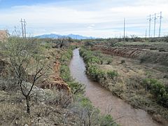
The Santa Cruz River near Red Rock.
|
|
 |
|
| Countries | United States, Mexico |
| States | Arizona, Sonora |
| Physical characteristics | |
| Main source | San Rafael Valley Santa Cruz County, Arizona 31°27′16″N 110°35′17″W / 31.45444°N 110.58806°W |
| River mouth | Gila River Santa Cruz Flats 1,014 ft (309 m) 33°19′N 112°14′W / 33.317°N 112.233°W |
| Length | 184 miles (296 km) |
| Basin features | |
| Tributaries |
|
The Santa Cruz River (which means "Holy Cross River" in Spanish) is a river that flows through Southern Arizona in the United States and northern Sonora, Mexico. It's about 184 miles (296 km) long. This river is a tributary to the Gila River, meaning it flows into the Gila River.
Contents
Where the Santa Cruz River Flows

The Santa Cruz River starts in the grassy San Rafael Valley in Arizona. This area is between the Canelo Hills and the Patagonia Mountains, close to the border with Mexico.
First, the river flows south into Mexico. It passes by a town called Santa Cruz, Sonora. Then, it turns west and heads north again. It re-enters the United States near Nogales, Arizona.
From there, the river continues north. It flows past important places like the Tumacácori National Historical Park, Tubac, Green Valley, and Tucson. It then goes past Marana and Picacho Peak State Park. The river ends in the Santa Cruz Flats, south of Casa Grande, where it joins the Gila River.
Mountains Along the River
Between Nogales and Tucson, mountains surround the river valley. On the east side are the San Cayetano and Santa Rita Mountains. On the west side are the Atascosa, Tumacacori, and Sierrita Mountains.
River's Water Flow: Past and Present
Most of the Santa Cruz River is usually a dry riverbed. It only flows with water when there has been a lot of rain. This wasn't always the case. In the late 1800s, the river started to dry up. This happened because of human actions and natural events.
Why the River Dried Up
Before it dried up, water flowed all year in many places. The riverbanks were lined with trees like cottonwood and mesquite. Historians and scientists don't fully agree on the biggest reasons for the river's decline. However, some human factors played a role:
- Too much grazing by animals.
- Pumping too much water from underground for farming and factories.
- Building dams and ditches.
By the mid-1900s, the part of the river that flowed through Tucson was completely dry.
Bringing Water Back to the River
Since 1951, the city of Nogales, Sonora, has been releasing treated wastewater into the Santa Cruz River. This has helped bring water back to several miles of the river near Nogales, Arizona.
In recent years, people have worked hard to save water and restore the river. Because of these efforts, water now flows all year in some parts of the Santa Cruz River near Tucson.
- In June 2019, Tucson started releasing treated wastewater daily into the riverbed. This project is called the Santa Cruz River Heritage Project. It has brought water back to about a 1-mile (1.6 km) stretch near downtown Tucson.
- Further upstream, water also returned to a half-mile (0.8 km) part of the river in 2019. This was on the San Xavier Indian Reservation of the Tohono Oʼodham Nation. It happened because less groundwater was pumped, as more water became available from the Central Arizona Project.
These efforts have helped plants grow again along the river. This includes new cottonwood trees and seep-willow plants.
Fun Activities Along the River
The Juan Bautista de Anza National Historic Trail runs alongside much of the Santa Cruz River. This trail is great for walking, biking, and exploring.
In Marana, there are about ten miles of paved paths. These paths are perfect for different outdoor activities. They are located along the Santa Cruz River, near Tangerine Road and through the Gladden Farms community park.
Gallery
-
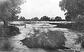
Little waterfalls along the Santa Cruz River in downtown Tucson in 1889.
-
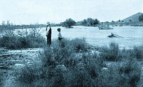
The Santa Cruz during a flood, c.1903.
-
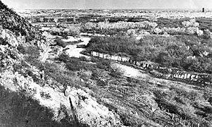
View of the Santa Cruz from "A" Mountain in 1904. Notice the riparian gallery forest, which has since become extinct.
-
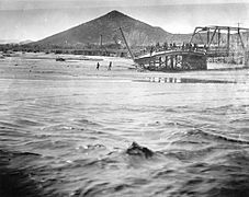
A wrecked bridge along the Santa Cruz during the flood of 1915. "A" Mountain is in the background.
-
A view of the Santa Cruz south of Tucson, facing south. The Santa Rita Mountains are in the background.


.jpg)
See also
 In Spanish: Río Santa Cruz (Arizona) para niños
