
San Rafael Valley facts for kids
Quick facts for kids San Rafael Valley |
|
|---|---|

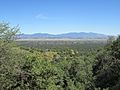
The San Rafael Valley, facing east toward the Canelo Hills and the Huachuca Mountains.
|
|
| Geography | |
| Country | United States |
| State | Arizona |
| Communities | Lochiel |
| Borders on | Canelo Hills-N Huachuca Mountains-E Patagonia Mountains-W |
| River | Santa Cruz River |
The San Rafael Valley is a large, grassy valley located in southeastern Arizona, in Santa Cruz County. It sits high up between several mountain ranges. To its west are the Patagonia Mountains. The Canelo Hills are to the north and northeast. To the east, you'll find the Huachuca Mountains. This valley is where the Santa Cruz River begins. The river then flows south into Sonora, Mexico, near the historic town of Lochiel.
Contents
A Special Place in Arizona
The San Rafael Valley is a unique area. It is known for its wide-open grasslands. It also has beautiful views of the mountains around it. This valley is important for its natural beauty. It is also important for its history.
Land and History
A large part of the valley is covered by the San Rafael de la Zanja Land Grant. This is a historic piece of land. It is located in the center of the valley. It sits just north of the town of Lochiel.
In 1998, a group called The Nature Conservancy bought this land. They wanted to protect its natural features. The next year, in 1999, Arizona created the "San Rafael State Natural Area." This protected area is on the southern part of the land grant. It borders Mexico.
Protecting Nature
The San Rafael State Natural Area helps protect the valley's plants and animals. This area is not open to the public. This helps keep the natural environment safe. The rest of the land grant is privately owned.
Historic Ranch
The main buildings of the San Rafael Ranch are also very old. In 2008, these buildings were added to the National Register of Historic Places. This means they are recognized as important historical sites. The ranch headquarters is now called the "San Rafael Ranch Historic District."
Images for kids
-
View across the San Rafael Valley towards the Huachuca Mountains.
-
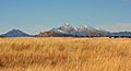
The San Rafael Valley with the Santa Rita Mountains in the background.
-
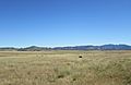
Cattle grazing in San Rafael Valley.
-
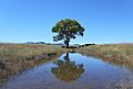
Cattle next to a water tank.

.jpg)


See also
 In Spanish: Valle de San Rafael para niños
