
Lochiel, Arizona facts for kids
Quick facts for kids
Lochiel, Arizona
|
|
|---|---|

Road signs in Lochiel. Part of the town and the international border can be seen in the background.
|
|

Lochiel, Arizona
Location in Arizona

Lochiel, Arizona
Location in the United States
|
|
| Country | United States |
| State | Arizona |
| County | Santa Cruz |
| Elevation | 4,685 ft (1,428 m) |
| Time zone | UTC-7 (Mountain (MST)) |
| FIPS code | 04-41750 |
| GNIS feature ID | 31163 |
Lochiel is a small, mostly empty place in southern Santa Cruz County, Arizona, in the United States. It's about 25 miles east of Nogales. Once, it was a busy border crossing point. Today, it's almost like a ghost town.
Lochiel is located in the beautiful San Rafael Valley, near Washington Gulch. People first settled here in the late 1870s. By 1986, most people had left. The town was important for nearby ranches and mining towns like Washington Camp and Duquesne.
Contents
What's in a Name? The Story of Lochiel
The area we now call Lochiel had a few different names over time. Local Mexican settlers first called it La Noria. This Spanish name means "a wheel-drawn well," which was likely important for water. Later, it was known as Luttrell.
In 1884, a rancher named Colin Cameron renamed the town "Lochiel." He named it after his homeland in Scotland. "Lochiel" is the name of the main branch of Clan Cameron, a famous Scottish family.
A Glimpse into Lochiel's Past
Early Settlers and a Mining Boom
The Lochiel area was first home to a small group of Mexican ranchers. In the late 1870s, a smelting works was built here. This factory processed metals from nearby mines in the Patagonia Mountains. This brought many American settlers to the area.
By 1881, the town, then called Luttrell, had grown quite a bit. About 400 people lived there. Most of them worked in the smelter or the mines. The town had five stores, three saloons, a brewery, a butcher shop, a bakery, and places to keep horses. There was even a boarding house run by Dr. James Monroe Luttrell, who the town was first named after.
The Border and Ranching Life
In 1884, a wealthy cattle rancher named Colin Cameron started the San Rafael Ranch. This ranch was about a mile north of Luttrell. That same year, he convinced the town's postmaster to rename the town "Lochiel," honoring his Scottish roots.
A few years later, officials surveyed the international border between Sonora, Mexico, and Arizona. They discovered that half of the town was actually in Mexican territory! So, the town was split in two. The Mexican part became known as La Noria, while the American side remained Lochiel.
In the early 1910s, a famous figure named Pancho Villa and his group sometimes took cattle and horses from the area. Around this time, a well-known businessman, William Cornell Greene, bought the San Rafael Ranch. He used it as the main office for his large cattle ranching business. Greene's family owned the ranch until 1998. Then, it was sold to The Nature Conservancy and Arizona State Parks. Today, it's a nature preserve, helping to protect the land and wildlife.
Lochiel Today: A Quiet Place with History
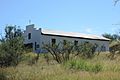
Even today, a few people still live in Lochiel. You can find several old houses there. Lochiel is also home to an adobe one-room schoolhouse, which is a school with just one classroom. There's also a teacherage, which was a home for the teacher. You can also see an old adobe church and a cemetery. An abandoned U.S. Customs station also stands there, reminding us of its past as a border crossing.
Lochiel is also a historically important spot. It's believed to be where Fray Marcos de Niza first entered what is now Arizona. He was one of the first Europeans to explore this region. In 1939, a large monument was built just west of town to honor him. It was built by the National Youth Administration.
Images for kids
-
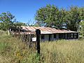
The U.S. Customs station.
-
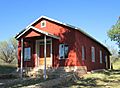
The one-room schoolhouse, built sometime before 1905.
-
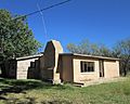
The teacherage next to the schoolhouse.
-
An old adobe church.
-
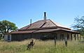
The Sunwest Ranch House in Lochiel.
-
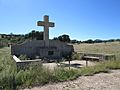
The monument to Fray Marcos de Niza, the first European west of the Rocky Mountains.


