Santa Cruz County, Arizona facts for kids
Quick facts for kids
Santa Cruz County
|
||
|---|---|---|
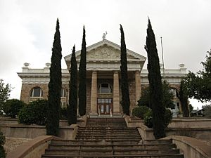
Santa Cruz County Courthouse
|
||
|
||
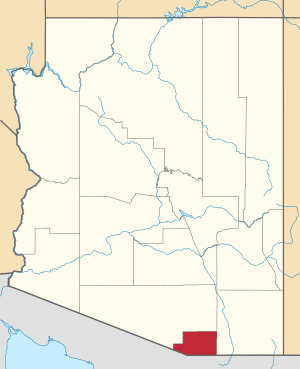
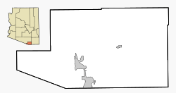
Location within the U.S. state of Arizona
|
||
 Arizona's location within the U.S. |
||
| Country | ||
| State | ||
| Founded | March 15, 1899 | |
| Named for | Santa Cruz River | |
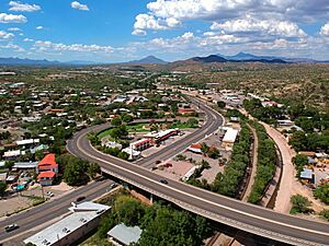
| Seat | Nogales | |
| Largest city | Nogales | |
| Area | ||
| • Total | 1,238 sq mi (3,210 km2) | |
| • Land | 1,237 sq mi (3,200 km2) | |
| • Water | 1.2 sq mi (3 km2) 0.1% | |
| Population
(2020)
|
||
| • Total | 47,669 | |
| • Estimate
(2023)
|
49,158 |
|
| • Density | 38.505/sq mi (14.867/km2) | |
| Time zone | UTC−7 (Mountain) | |
| Congressional district | 7th | |
Santa Cruz County is a special area called a county in southern Arizona, United States. It's like a big neighborhood with its own local government. In 2020, about 47,669 people lived here. The main town, or county seat, is Nogales.
Santa Cruz County was created in 1899. It shares borders with Pima County to the north and west, Cochise County to the east, and the country of Mexico (specifically the state of Sonora) to the south. The county is part of a larger area that includes Tucson, making it an important place for both local life and bigger regional connections.
Contents
History of Santa Cruz County
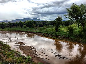
Santa Cruz County was officially formed on March 15, 1899. It was created from a part of what was then Pima County. The county gets its name from the Santa Cruz River. This river starts in the Canelo Hills within the eastern part of the county. It then flows south into Mexico near the town of Santa Cruz, Sonora. After a bend, it flows back north into the United States, re-entering Santa Cruz County east of Nogales.
Early Explorers and Missions
In the 1690s, an Italian explorer and missionary named Father Eusebio Kino explored this area for the Spanish Empire. He named the Santa Cruz River, which means "holy cross" in Spanish. Father Kino also started several missions to teach the O'odham peoples living along the Santa Cruz River. These missions included San Cayetano del Tumacácori (1691) and San Gabriel de Guevavi (1691). He also founded Los Reyes de Sonoita (1692) near Sonoita Creek.
Some of Kino's missions were destroyed in the O'odham peoples' 1751 Pima Revolt. They were later rebuilt as Missions Los Santos Ángeles de Guevavi (1751), San José de Tumacácori (1753), and San Cayetano de Calabazas (1756). Today, you can see the ruins of these three later missions at Tumacácori National Historical Park.
Geography of Santa Cruz County
Santa Cruz County covers about 1,238 square miles. Most of this area, about 1,237 square miles, is land. Only a small part, about 1.2 square miles, is water. It is the smallest county in Arizona by land area.
Neighboring Areas
Santa Cruz County shares its borders with several other counties and towns:
- Pima County to the west and north
- Cochise County to the east
- Nogales, Sonora, Mexico to the south
- Santa Cruz, Sonora, Mexico to the south
- Sáric, Sonora, Mexico to the south
Main Roads and Highways
Important roads help people travel through Santa Cruz County:
 Interstate 19
 State Route 82
 State Route 83
Protected Natural Areas
Parts of these special natural areas are found in Santa Cruz County:
- Coronado National Forest
- Las Cienegas National Conservation Area
- Tumacácori National Historical Park
Border Crossings to Mexico
There are three main places where people can cross the U.S.-Mexico border in Nogales:
- The Dennis DeConcini Port of Entry for cars and people.
- The Nogales-Mariposa Port of Entry in the western part of the city for cars and people.
- The Morley Gate Port of Entry for people walking only.
The town of Lochiel used to have a border crossing, but it was closed in 1983.
Population and People
| Historical population | |||
|---|---|---|---|
| Census | Pop. | %± | |
| 1900 | 4,545 | — | |
| 1910 | 6,766 | 48.9% | |
| 1920 | 12,689 | 87.5% | |
| 1930 | 9,684 | −23.7% | |
| 1940 | 9,482 | −2.1% | |
| 1950 | 9,417 | −0.7% | |
| 1960 | 10,808 | 14.8% | |
| 1970 | 13,966 | 29.2% | |
| 1980 | 20,459 | 46.5% | |
| 1990 | 29,676 | 45.1% | |
| 2000 | 38,381 | 29.3% | |
| 2010 | 47,420 | 23.6% | |
| 2020 | 47,669 | 0.5% | |
| 2023 (est.) | 49,158 | 3.7% | |
| U.S. Decennial Census 1790–1960 1900–1990 1990–2000 2010–2020 |
|||
In 2010, there were 47,420 people living in Santa Cruz County. About 82.8% of the people living here were of Hispanic or Latino background.
Ancestry Groups
Many people in Santa Cruz County have roots from different parts of the world. The largest groups include:
Communities in Santa Cruz County
Santa Cruz County has different types of communities, from cities to small, spread-out areas.
Cities
- Nogales is the main city and the county seat.
Towns
- Patagonia is another important town.
Census Designated Places (CDPs)
These are areas that are like towns but don't have their own local government.
Unincorporated Communities
These are smaller communities that are not officially part of a city or town.
- Harshaw
- Oro Blanco
- Carmen
- Lochiel
- Trench Camp
- Casa Piedra
- Madera Canyon
- Washington Camp
Ghost Towns
Some places in Santa Cruz County used to be busy but are now mostly empty. These are called ghost towns.
Education in Santa Cruz County
Students in Santa Cruz County attend schools in different school districts.
School Districts
- Nogales Unified School District (for all grades, K-12)
- Santa Cruz Valley Unified School District (for all grades, K-12)
- Patagonia Union High School District (for high school)
- Patagonia Elementary District (for elementary school)
- Santa Cruz Elementary District (for elementary school)
- Sonoita Elementary District (for elementary school)
Economy of Santa Cruz County
Since Santa Cruz County is the smallest county in Arizona, its economic activities are also smaller. The main type of farming here is growing forage (like hay) for animals. Almost all of the farm products each year come from cattle and other animals raised on this hay and pasture land.
See also
 In Spanish: Condado de Santa Cruz (Arizona) para niños
 | Dorothy Vaughan |
 | Charles Henry Turner |
 | Hildrus Poindexter |
 | Henry Cecil McBay |


