
Nogales, Arizona facts for kids
Quick facts for kids
Nogales
|
|||
|---|---|---|---|
| City of Nogales | |||

the view of Nogales
|
|||
|
|||

Location of Nogales in Santa Cruz County, Arizona
|
|||

Nogales
Location in Arizona

Nogales
Location in the United States
|
|||
| Country | United States | ||
| State | Arizona | ||
| County | Santa Cruz | ||
| Incorporated | 1893 | ||
| Government | |||
| • Type | Council-manager | ||
| • Body | Nogales City Council | ||
| Area | |||
| • Total | 20.83 sq mi (53.96 km2) | ||
| • Land | 20.82 sq mi (53.92 km2) | ||
| • Water | 0.01 sq mi (0.04 km2) | ||
| Elevation | 3,829 ft (1,167 m) | ||
| Population
(2020)
|
|||
| • Total | 19,770 | ||
| • Density | 949.57/sq mi (366.63/km2) | ||
| Time zone | UTC-7 (MST (no DST)) | ||
| ZIP codes |
85621
|
||
| Area code(s) | 520 | ||
| FIPS code | 04-49640 | ||
| GNIS feature ID | 32336 | ||


Nogales is a city in Arizona, USA. It's the main city of Santa Cruz County. In 2020, about 19,770 people lived there.
Nogales is special because it sits right on the border with Mexico. It has a "twin city" called Nogales, Sonora in Mexico. These two cities are like one big community, even though they are in different countries!
The name Nogales comes from the Spanish word for 'walnut trees'. Many walnut trees used to grow in the mountain pass where the city is located.
This border city is a very important place for trade. It has four main entry points where people and goods can cross. A lot of fresh food and products from Mexico come into the United States through Nogales. This trade helps create many jobs in both Arizona and Sonora.
Contents
History of Nogales


The name Nogales means 'walnut trees' in Spanish. This is because many walnut trees once grew in the mountain pass here.
In 1775, the Juan Bautista de Anza Expedition passed through this area. This expedition was a journey from New Spain (which is now Mexico) into what is now the United States. Today, you can find a small room in the 1904 Nogales Courthouse that tells the story of this important journey.
In 1841, a Mexican family, the Elías family, was given land here. They called it Los Nogales de Elías. After the Gadsden Purchase in 1853, Nogales became part of the United States.
In 1880, two brothers, Isaac and Jacob Isaacson, started a trading post here. It was first called Isaacson, Arizona. But in 1883, the post office changed the name to Nogales.
In 1915, a fence was built to separate Nogales, Sonora, from Nogales, Arizona. But it was taken down just four months later.
A battle happened here on August 27, 1918, between the United States Army and Mexican citizens. After this battle, the first permanent border wall was built between Nogales, Arizona, and Nogales, Sonora.
People of Nogales
| Historical population | |||
|---|---|---|---|
| Census | Pop. | %± | |
| 1890 | 1,194 | — | |
| 1900 | 1,761 | 47.5% | |
| 1910 | 3,514 | 99.5% | |
| 1920 | 5,199 | 48.0% | |
| 1930 | 6,006 | 15.5% | |
| 1940 | 5,135 | −14.5% | |
| 1950 | 6,153 | 19.8% | |
| 1960 | 7,286 | 18.4% | |
| 1970 | 8,946 | 22.8% | |
| 1980 | 15,683 | 75.3% | |
| 1990 | 19,489 | 24.3% | |
| 2000 | 20,878 | 7.1% | |
| 2010 | 20,837 | −0.2% | |
| 2020 | 19,770 | −5.1% | |
| U.S. Decennial Census | |||
In 2010, there were about 20,878 people living in Nogales. Most people in Nogales are of Hispanic or Latino background, making up about 95% of the population.
The city has many families. About 38.8% of households have children under 18 living with them. The average household has about 3 people.
The median age in Nogales is 30 years old. This means half the people are younger than 30 and half are older.
Geography and Climate
Nogales is located at an elevation of about 3,829 feet (1,167 meters) above sea level. The city covers an area of about 20.8 square miles (53.9 square kilometers).
Nogales Weather
Nogales has a semi-arid climate. This means it's less hot and gets more rain than a typical desert.
- Winters: Winters are mild. Daily high temperatures are usually in the 60s Fahrenheit (around 18-20°C). Nights are cool, often just above freezing.
- Summers: Summers are hot. Daily highs are usually between 90 and 100°F (32-38°C). June is often the hottest month.
- Rainy Season: July and August are the rainiest months. This is due to the Arizona Monsoon. During this time, storms can bring a lot of rain quickly.
The highest temperature ever recorded in Nogales was 112°F (44°C) on June 26, 1990. The lowest was -4°F (-20°C) on December 8, 1978.
| Climate data for Nogales, Arizona (Nogales International Airport) (1991–2020 normals, extremes 1999–present) | |||||||||||||
|---|---|---|---|---|---|---|---|---|---|---|---|---|---|
| Month | Jan | Feb | Mar | Apr | May | Jun | Jul | Aug | Sep | Oct | Nov | Dec | Year |
| Record high °F (°C) | 82 (28) |
88 (31) |
90 (32) |
98 (37) |
106 (41) |
112 (44) |
110 (43) |
105 (41) |
104 (40) |
100 (38) |
91 (33) |
82 (28) |
112 (44) |
| Mean maximum °F (°C) | 77.3 (25.2) |
80.5 (26.9) |
86.5 (30.3) |
91.3 (32.9) |
97.7 (36.5) |
105.3 (40.7) |
102.9 (39.4) |
100.2 (37.9) |
97.7 (36.5) |
93.0 (33.9) |
85.7 (29.8) |
78.8 (26.0) |
106.2 (41.2) |
| Mean daily maximum °F (°C) | 65.8 (18.8) |
67.6 (19.8) |
73.3 (22.9) |
79.4 (26.3) |
87.7 (30.9) |
96.9 (36.1) |
94.1 (34.5) |
92.2 (33.4) |
90.3 (32.4) |
83.1 (28.4) |
73.3 (22.9) |
64.9 (18.3) |
80.7 (27.1) |
| Daily mean °F (°C) | 50.0 (10.0) |
51.7 (10.9) |
56.8 (13.8) |
61.9 (16.6) |
69.9 (21.1) |
79.6 (26.4) |
80.5 (26.9) |
78.9 (26.1) |
75.4 (24.1) |
66.3 (19.1) |
56.7 (13.7) |
49.4 (9.7) |
64.8 (18.2) |
| Mean daily minimum °F (°C) | 34.1 (1.2) |
35.9 (2.2) |
40.3 (4.6) |
44.4 (6.9) |
52.1 (11.2) |
62.4 (16.9) |
66.9 (19.4) |
65.6 (18.7) |
60.5 (15.8) |
49.5 (9.7) |
40.1 (4.5) |
33.9 (1.1) |
48.8 (9.3) |
| Mean minimum °F (°C) | 21.2 (−6.0) |
23.1 (−4.9) |
29.1 (−1.6) |
33.5 (0.8) |
41.8 (5.4) |
53.3 (11.8) |
61.8 (16.6) |
60.3 (15.7) |
52.1 (11.2) |
37.7 (3.2) |
28.7 (−1.8) |
21.6 (−5.8) |
18.1 (−7.7) |
| Record low °F (°C) | 10 (−12) |
11 (−12) |
22 (−6) |
28 (−2) |
33 (1) |
48 (9) |
53 (12) |
52 (11) |
43 (6) |
24 (−4) |
20 (−7) |
14 (−10) |
10 (−12) |
| Average precipitation inches (mm) | 0.84 (21) |
0.78 (20) |
0.63 (16) |
0.28 (7.1) |
0.15 (3.8) |
0.54 (14) |
4.18 (106) |
3.41 (87) |
1.53 (39) |
0.65 (17) |
0.62 (16) |
1.01 (26) |
14.62 (371) |
| Average precipitation days (≥ 0.01 in) | 4.1 | 3.9 | 2.8 | 1.6 | 1.1 | 3.2 | 15.1 | 14.0 | 6.6 | 3.4 | 2.5 | 4.3 | 62.6 |
| Source 1: NOAA | |||||||||||||
| Source 2: National Weather Service (mean maxima/minima 2006–2020) | |||||||||||||
| Climate data for Nogales 6 N, Arizona (1991–2020 normals, extremes 1952–present) | |||||||||||||
|---|---|---|---|---|---|---|---|---|---|---|---|---|---|
| Month | Jan | Feb | Mar | Apr | May | Jun | Jul | Aug | Sep | Oct | Nov | Dec | Year |
| Record high °F (°C) | 85 (29) |
89 (32) |
95 (35) |
99 (37) |
107 (42) |
112 (44) |
109 (43) |
107 (42) |
103 (39) |
101 (38) |
93 (34) |
83 (28) |
112 (44) |
| Mean maximum °F (°C) | 77.4 (25.2) |
79.7 (26.5) |
85.2 (29.6) |
91.5 (33.1) |
98.4 (36.9) |
104.7 (40.4) |
103.5 (39.7) |
100.5 (38.1) |
97.7 (36.5) |
93.9 (34.4) |
85.2 (29.6) |
77.6 (25.3) |
105.7 (40.9) |
| Mean daily maximum °F (°C) | 65.3 (18.5) |
67.2 (19.6) |
72.8 (22.7) |
79.4 (26.3) |
87.4 (30.8) |
96.5 (35.8) |
94.4 (34.7) |
92.3 (33.5) |
90.5 (32.5) |
83.5 (28.6) |
73.4 (23.0) |
64.6 (18.1) |
80.6 (27.0) |
| Daily mean °F (°C) | 46.8 (8.2) |
48.8 (9.3) |
53.9 (12.2) |
59.4 (15.2) |
66.9 (19.4) |
76.4 (24.7) |
79.8 (26.6) |
78.2 (25.7) |
74.0 (23.3) |
64.1 (17.8) |
53.9 (12.2) |
46.3 (7.9) |
62.4 (16.9) |
| Mean daily minimum °F (°C) | 28.3 (−2.1) |
30.5 (−0.8) |
35.0 (1.7) |
39.5 (4.2) |
46.3 (7.9) |
56.3 (13.5) |
65.3 (18.5) |
64.0 (17.8) |
57.5 (14.2) |
44.6 (7.0) |
34.4 (1.3) |
28.0 (−2.2) |
44.1 (6.7) |
| Mean minimum °F (°C) | 18.6 (−7.4) |
20.8 (−6.2) |
25.3 (−3.7) |
29.4 (−1.4) |
36.2 (2.3) |
45.1 (7.3) |
56.4 (13.6) |
57.6 (14.2) |
47.9 (8.8) |
32.8 (0.4) |
22.5 (−5.3) |
17.9 (−7.8) |
15.1 (−9.4) |
| Record low °F (°C) | 8 (−13) |
9 (−13) |
13 (−11) |
7 (−14) |
25 (−4) |
34 (1) |
44 (7) |
40 (4) |
30 (−1) |
19 (−7) |
8 (−13) |
−4 (−20) |
−4 (−20) |
| Average precipitation inches (mm) | 0.98 (25) |
0.92 (23) |
0.69 (18) |
0.35 (8.9) |
0.17 (4.3) |
0.68 (17) |
3.59 (91) |
3.91 (99) |
2.23 (57) |
0.85 (22) |
0.59 (15) |
1.14 (29) |
16.10 (409) |
| Average snowfall inches (cm) | 0.3 (0.76) |
0.0 (0.0) |
0.0 (0.0) |
0.0 (0.0) |
0.0 (0.0) |
0.0 (0.0) |
0.0 (0.0) |
0.0 (0.0) |
0.0 (0.0) |
0.0 (0.0) |
0.0 (0.0) |
0.0 (0.0) |
0.3 (0.76) |
| Average precipitation days (≥ 0.01 in) | 4.8 | 4.8 | 3.5 | 1.6 | 1.4 | 2.3 | 14.2 | 13.7 | 7.0 | 3.2 | 3.2 | 5.5 | 65.2 |
| Average snowy days (≥ 0.1 in) | 0.0 | 0.0 | 0.0 | 0.0 | 0.0 | 0.0 | 0.0 | 0.0 | 0.0 | 0.0 | 0.0 | 0.1 | 0.1 |
| Source 1: NOAA | |||||||||||||
| Source 2: National Weather Service | |||||||||||||
Nogales Economy
The economy of Nogales relies a lot on trade across the border. Many fresh fruits and vegetables from Mexican farms come through Nogales. Also, factories in Nogales, Sonora, make goods that are then sent into the U.S.
Even though Nogales, Arizona, is smaller, it gets a lot of visitors from its twin city, Nogales, Sonora. Many people from Mexico cross the border daily to shop in Nogales, Arizona. This shopping brings in a lot of money for the city.
The United States Department of Homeland Security is also a big employer in Nogales. Many people work for the Border Patrol and Customs and Border Protection here.
Some of the largest employers in Nogales include:
- Seattle Sports
- City of Nogales
- County of Santa Cruz
- Dependable Home Health
- E.D.S. Manufacturing
- Holy Cross Hospital
- The Home Depot
- Mariposa Community Health Center
- Nogales Unified School District
- Safeway
- Prestolite Wire
- UPS Supply Chain Solutions
- Walmart
Fun Places to Visit
Santa Cruz County and Nogales have many interesting historical places. Over 200 properties are listed on the National Register of Historic Sites.
- Tumacacori National Monument: This was first visited by Father Eusebio Kino in 1691.
- Tubac Presidio: This was a Spanish fort built in 1752 on an old Indian village site.
- Old Nogales City Hall and the Santa Cruz County Courthouse are also historic buildings.
The Santa Cruz County Historical Courthouse has a statue of Lady Justice on top. What's unique is that the Nogales Lady Justice does not wear a blindfold!
You can also see interesting old homes along Crawford and Court Streets. These homes show what border life was like a long time ago.
If you love nature, there are several state parks and recreation areas nearby:
- Patagonia State Park
- Peña Blanca Lake
- Parker Canyon Lake
- Coronado National Forest
The Patagonia-Sonoita Creek Sanctuary is a great place to see many different kinds of birds. It attracts visitors from all over the world! You can also visit the Wine Country of Sonoita-Elgin, which is about 20 miles east of Nogales.
Getting Around Nogales
Nogales is at the very south end of Interstate 19. This highway connects to Mexican Federal Highway 15 at the border. Arizona State Route 189 also connects to the main border crossing.
The Nogales International Airport is a local airport for general use.
For bus travel, companies like Greyhound and TUFESA connect Nogales to Tucson and other cities to the north.
Famous People from Nogales
Many notable people have connections to Nogales:
- Bob Baffert – A famous horse trainer who has won the Triple Crown.
- Movita Castaneda – An actress.
- Travis Edmonson – A musician from the folk duo "Bud & Travis."
- John Frederick "Jack" Hannah – An Academy Award-winning artist and director for Disney Studios.
- Charles Mingus – A very famous jazz bass player and composer.
- Jack O'Connor – A longtime editor for Outdoor Life magazine.
- Alberto Alvaro Ríos – An author and poet, and Arizona's current Poet Laureate.
- Roger Smith – An actor from the TV show 77 Sunset Strip.
Images for kids
-
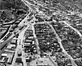
View of Nogales, 1940s

See also
 In Spanish: Nogales (Arizona) para niños
