
Las Cienegas National Conservation Area facts for kids
Quick facts for kids Las Cienegas National Conservation Area |
|
|---|---|
|
IUCN Category V (Protected Landscape/Seascape)
|
|

Cienega Creek
|
|

Las Cienegas National Conservation Area
Location in the United States
|
|
| Location | Pima and Santa Cruz counties, Arizona, United States |
| Nearest city | Sierra Vista, Arizona |
| Area | 45,000 acres (180 km2) |
| Established | 2000 |
| Governing body | Bureau of Land Management |
| Website | Las Cienegas National Conservation Area |
The Las Cienegas National Conservation Area is a special protected area in Arizona, United States. It's like a natural treasure located where two big deserts meet: the Sonoran Desert and the Chihuahuan Desert. This area helps protect important plants, animals, and historical places for everyone to enjoy.
Protecting a Special Place
This special place, the Las Cienegas National Conservation Area, covers over 45,000 acres (about 182 square kilometers). It's in Pima and Santa Cruz counties in Arizona. This land was protected because there was a risk of too much housing and business development.
The area has beautiful rolling grasslands and woodlands. You can also find hills covered with oak trees. These hills connect different "sky island" mountain ranges. These unique landscapes attract both people and many kinds of wildlife.
Ciénega Creek: A Lifeline
A very important part of this area is Ciénega Creek. This creek flows all year round, which is unusual for a desert region. The area around the creek is called a riparian corridor. It's a lush, green strip of land that supports a wide variety of plants and animals. It's like an oasis in the desert.
How the Area is Managed
Several historic ranches, including Empire and Cienega ranches, are part of this protected land. They are now owned by the public. The Bureau of Land Management (BLM) takes care of this area. They manage it using principles of "multiple-use" and "ecosystem management". This means they try to balance different uses, like recreation and conservation, while keeping the natural environment healthy.
The BLM also works with a group called the Empire Ranch Foundation. This foundation is dedicated to keeping the old ranch buildings and the land around them safe and preserved for the future.
Gallery
-
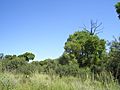
Cottonwood trees along Cienega Creek.
-
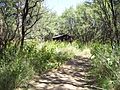
An old shack along Cienegas Creek.
-
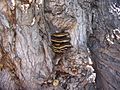
Bracket fungus in the NCA.


