Patagonia, Arizona facts for kids
Quick facts for kids
Patagonia, Arizona
|
|
|---|---|
|
Town
|
|

Town hall
|
|

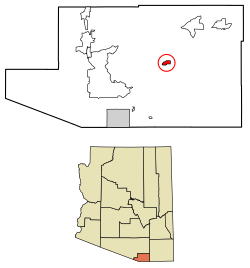
Location of Patagonia in Santa Cruz County, Arizona
|
|
| Country | United States |
| State | Arizona |
| County | Santa Cruz |
| Government | |
| • Type | Council–manager |
| • Body | Patagonia Town Council |
| Area | |
| • Total | 1.29 sq mi (3.35 km2) |
| • Land | 1.29 sq mi (3.34 km2) |
| • Water | 0.00 sq mi (0.01 km2) |
| Elevation | 4,058 ft (1,237 m) |
| Population
(2020)
|
|
| • Total | 804 |
| • Density | 623.74/sq mi (240.76/km2) |
| Time zone | UTC-7 (MST (no DST)) |
| ZIP code |
85624
|
| Area code(s) | 520 |
| FIPS code | 04-53490 |
| GNIS feature ID | 32726 |
| Website | https://patagonia-az.gov |
Patagonia is a small town in Santa Cruz County, Arizona, United States. In 2010, about 913 people lived there. This town started in the mid-1800s. It was a place where nearby mines and ranches could trade and get supplies. Today, Patagonia is a popular spot for tourists. It is also a place where people retire and where artists create and sell their crafts.
Contents
Exploring Patagonia's Location
The town of Patagonia sits in a valley. This valley is between two mountain ranges. To the north are the Santa Rita Mountains. To the south are the Patagonia Mountains. State Route 82 goes right through the town.
Nearby Ghost Towns and Parks
Some old mining camps are nearby. These are now ghost towns. They include Harshaw, Duquesne, and Lochiel. They are located southeast of Patagonia. The high San Rafael Valley is also to the southeast. Patagonia Lake State Park is about six miles southwest of town. It is a popular place for outdoor fun.
A Look at Patagonia's Past
The area around Patagonia has a long history. Native American groups lived here for a very long time. They found lots of food from hunting and fishing. Archaeologists have found old villages and rock carvings. This area was once a seasonal village called Sonoitac. It belonged to the Tohono O'odham people.
Early European Visitors
In 1539, a Spanish explorer named Fray Marcos de Niza came to this region. He explored near Lochiel, close to the Mexican border. He was the first European to visit what is now Arizona. The main Native American tribes here were the Sobaipuri and Papago (now called Tohono O'odham).
In 1692, Father Eusebio Francisco Kino arrived as a missionary. He wanted to teach the native people about Catholicism. This area became part of his mission, Mission Los Santos Ángeles de Guevavi. By 1698, Father Kino's group reached Sonoita Creek. They met groups of native people living along the creek. This area later became Patagonia.
How Patagonia Got Its Name
According to Gilbert Quiroga, who leads the Patagonia Museum, Welsh miners came to this area. They were from Patagonia, a region in South America. That region is shared by Argentina and Chile. The mountains in Arizona reminded them of the Andes mountains in South America. So, they started calling them the Patagonia Mountains. The Native Americans had called these mountains Chihuahuillas.
Changes in Control
The mission period ended in 1768. This was due to a rule by Charles III of Spain. In 1821, Mexico won its independence from Spain. The land, including Arizona, became part of Mexico.
By the mid-1850s, people were mining silver in the mountains east of Sonoita. By the 1860s, a lot of silver and lead were found. In 1854, the United States bought this region from Mexico. This was called the Gadsden Purchase. People from the eastern U.S. started to move here. The U.S. Military protected them from attacks by the Apaches.
The Civil War and Its Impact
Most soldiers left the area when the American Civil War began. Fort Buchanan, a small army base, was taken over by the Apaches. Miners, ranchers, and farmers were left without protection. Many of them moved away.
The Civil War ended in 1865. In 1867, the U.S. Army built Camp Crittenden near Sonoita. This camp, later called Fort Crittenden, fought against the Apache people. Its goal was to protect the American pioneers. Miners, ranchers, and farmers then returned to the area.
Founding the Town
Rollin Rice Richardson was a veteran of the Civil War. He became very rich from mining. In 1896, Rollin hired J.C. Green to plan a settlement. This is how he founded the town that year. In 1899, he wanted to open a post office. Richardson wanted the town named "Rollin" after himself. But the people living there disagreed. They asked the U.S. Post Master General to name the town Patagonia. They wanted it named after the nearby mountains. In 1900, the U.S. Postal Office Department officially recognized Patagonia as the town's name.
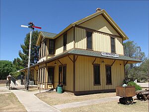
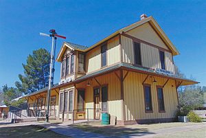
That same year, a two-story railroad station was built. Patagonia became a key business center for mining in Santa Cruz County. Ranching and cattle farming were also very important. The new railroad helped ranchers and miners. They could now easily send their products out and get goods in.
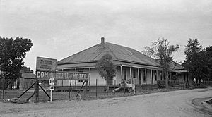
By 1917, Patagonia had many modern features. It had running water, an Opera House, three hotels, a school, two parks, and many stores. Richardson was very influential in the town until he died in 1923. Patagonia officially became a town in 1948.
Patagonia's Population
| Historical population | |||
|---|---|---|---|
| Census | Pop. | %± | |
| 1950 | 700 | — | |
| 1960 | 540 | −22.9% | |
| 1970 | 630 | 16.7% | |
| 1980 | 980 | 55.6% | |
| 1990 | 888 | −9.4% | |
| 2000 | 881 | −0.8% | |
| 2010 | 913 | 3.6% | |
| 2020 | 804 | −11.9% | |
| U.S. Decennial Census | |||
In 2000, there were 881 people living in Patagonia. There were 404 households. About 23% of households had children under 18. About 47% were married couples. In 2010, Patagonia's population was 913. About 56% of the people were non-Hispanic white. About 42% were Hispanic or Latino. In 2020, the population was 804.
Famous People from Patagonia
- Erik Asphaug, a scientist who studies planets
- Philip Caputo, an author
- Jim Harrison, a writer, poet, and food critic
- Hilde Lysiak, a journalist
- Gary Nabhan, a writer and expert on plants and cultures
See also
 In Spanish: Patagonia (Arizona) para niños
 | Aaron Henry |
 | T. R. M. Howard |
 | Jesse Jackson |


