
Sonoita Creek facts for kids
Quick facts for kids Sonoita Creek |
|
|---|---|

Sonoita Creek, facing downstream from Salero Road
|
|
| Country | United States |
| State | Arizona |
| County | Santa Cruz |
| Physical characteristics | |
| Main source | Two miles northwest of Sonoita 5000 ft 31°41′36″N 110°41′20″W / 31.69333°N 110.68889°W |
| River mouth | Santa Cruz River, Rio Rico, Arizona 3435 ft 31°27′41″N 110°58′45″W / 31.46139°N 110.97917°W |
| Length | 31 mi (50 km) |
| Basin features | |
| River system | Colorado River |
| Tributaries |
|
Sonoita Creek is a special stream in Santa Cruz County, Arizona. It's a tributary, which means it's a smaller stream that flows into a larger river. Sonoita Creek joins the Santa Cruz River.
This creek gets its name from an old Pima mission located in a high valley near Sonoita. It flows for about 15 miles (24 km) towards the west. Along its path, it passes by Patagonia, a famous bird sanctuary, and Patagonia Lake.
Even though it flows steadily for a while, the creek eventually sinks underground. This happens about seven to eight miles (11 to 13 km) before it reaches the Santa Cruz River, a few miles north of Nogales. The water from Sonoita Creek helps supply towns like Tumacácori and Tubac. It also fills the marshy areas around San Xavier del Bac further north.
The area around Sonoita Creek is surrounded by mountains and hills. To the north are the Santa Rita Mountains. To the south, you'll find the Canelo Hills, Red Mountain, and the Patagonia Mountains. Another stream, Harshaw Creek, flows into Sonoita Creek near Patagonia. Harshaw Creek drains the land between the Patagonia Mountains and the wide San Rafael Valley grasslands. The old ghost town of Harshaw is also in this area.
Amazing Animals of Sonoita Creek
Sonoita Creek is home to many different kinds of animals, especially fish and other water creatures. It's a busy place for wildlife!
Here are some of the animals you might find living in or near the creek:
- Fish:
- Other Water Animals:
Railroad History Along the Creek
A long time ago, a railroad called the New Mexico and Arizona Railroad followed parts of Sonoita Creek. This railway was built between 1881 and 1882.
- The Route: The railroad started by connecting with the Southern Pacific Railroad in Benson. From there, it went south to Fairbank, then west through Sonoita and Patagonia to Rio Rico, and finally south to Nogales.
- Changes Over Time: The railroad stopped being used in different sections between 1927 and 1962. Today, only about 15.74 km (9.78 mi) of the original track is still in use. This remaining part runs from Rio Rico to Nogales and is operated by the Union Pacific Railroad.
Images for kids
-

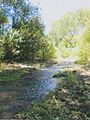
Riparian forest along Sonoita Creek, southwest of Patagonia Lake
-
Sonoita Creek in the summer of 2014
-
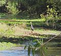
A great blue heron walking along Sonoita Creek


