
Canelo Hills facts for kids

The Canelo Hills are a group of low mountains or hills located in eastern Santa Cruz County, Arizona. They stretch from the Sonoita Creek valley near Sonoita all the way to the Parker Canyon Lake area. These hills connect with the Huachuca Mountains to the southeast. To the southwest, you'll find the San Rafael Valley, and to the west, across the Harshaw Creek valley, are the Patagonia Mountains. On the eastern side of the Canelo Hills, you can find the Canelo Hills Cienega Reserve and the old ghost town of Canelo, Arizona.
What are the Canelo Hills made of?
The Canelo Hills are mostly made up of rocks that are very old. These include sedimentary rocks from the Permian period and volcanic rocks from the Jurassic and Triassic periods. These rocks are often folded and faulted, meaning they have been bent and broken by Earth's movements.
Near the Patagonia Mountains, the rocks are younger, from the Cretaceous and Eocene periods.
The Parker Canyon Caldera
The southern part of the Canelo Hills shows signs of a huge ancient volcanic caldera. A caldera is a large, bowl-shaped hollow that forms when the ground collapses after a volcanic eruption. This one is called the Parker Canyon Caldera. It's shaped like a kidney bean and stretches about 15 miles (24 km) from north of Canelo Pass into the Huachuca Mountains. It also lies beneath the eastern part of the San Rafael Valley.
The Jurassic volcanic rocks in this area include rhyolite welded tuff. This is a type of rock formed from volcanic ash and fragments that were so hot they fused together. These rocks also contain large, unusual blocks of other rock types like limestone and quartzite. Scientists believe these blocks are "intercaldera megabreccia lenses," which means they are huge pieces of rock that fell into the volcano's vent during an eruption.
Images for kids
-
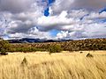
A view of the Canelo Hills
-
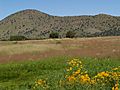
Canelo Hills and Bullfrog Pond
-
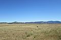
Cattle grazing in the San Rafael Valley, near the Canelo Hills
-
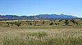
The wide San Rafael Valley, with the Canelo Hills in the distance
.jpg)


See also
 In Spanish: Lomas de Canelo para niños
