Rillito River facts for kids
Quick facts for kids Rillito River |
|
|---|---|

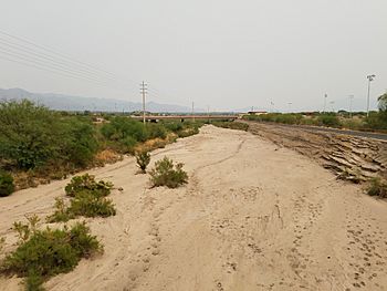
Dry riverbed near Dodge Blvd
|
|
| Country | United States |
| State | Arizona |
| City | Tucson, Arizona |
| Physical characteristics | |
| Main source | Confluence of North and South Forks Pima County, Arizona 32°16′7″N 110°52′31″W / 32.26861°N 110.87528°W |
| River mouth | Santa Cruz River Pima County, Arizona 2,195 ft (669 m) 32°18′49″N 111°3′18″W / 32.31361°N 111.05500°W |
| Length | 12.2 mi (19.6 km) |
| Basin features | |
| Tributaries |
|
The Rillito River is a river in Pima County, Arizona. Its name comes from a Spanish word meaning "Little River."
This river flows from east to west. It marks the northern edge of Tucson. The Rillito River starts where two other streams meet: Tanque Verde Creek and Pantano Wash. This meeting point is called a confluence.
From its start, the Rillito River flows about 12.2 miles (19.6 km) until it joins the Santa Cruz River. A popular path called the Rillito River Park runs along both sides of the river. You can find this park from Interstate 10 to North Craycroft Road.
What Was the Rillito River Like Before?
Before people built cities and farms, the area around the Rillito River was very different. It had many riparian habitats. These are special areas along rivers with lots of trees and plants.
In the late 1800s, the Rillito River always had water flowing in it. This is called a perennial stream. Its banks were full of trees like cottonwoods, willows, and mesquites.
Why Did the River Change?
Over time, people started to use a lot of groundwater. They pumped water from underground for farming and to supply the growing city of Tucson. This caused the river to dry up.
By the mid-1900s, most of the green, wet river habitat was gone. When the plants disappeared, the river banks became weak. During floods, the water would wash away the soil easily. This made the river channel wider and straighter.
What Is the Rillito River Like Today?
Today, the Rillito is an ephemeral river. This means it only has water when there are big floods or when snow melts. Most of the time, its riverbed is dry.
To control floods, people built up the river banks in the late 1900s. They used a strong material called soil cement. This helps stop the banks from washing away. It also keeps the water from overflowing and damaging nearby homes and businesses.
 | Aaron Henry |
 | T. R. M. Howard |
 | Jesse Jackson |

