
Sierrita Mountains facts for kids
Quick facts for kids Sierrita Mountains |
|
|---|---|

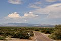
The Sierritas from the east.
|
|
| Highest point | |
| Peak | Keystone Peak |
| Elevation | 6,188 ft (1,886 m) |
| Geography | |

Sierrita Mountains
Location in Arizona
|
|
| Location | Pima County, Arizona |
| Country | United States |
| State | Arizona |
| Region | Sonoran Desert |
| District | Tucson, AZ |
| Topo map | USGS Samaniego, AZ |
The Sierrita Mountains are a small mountain range in Pima County, Arizona. Their name means "Little Mountains" in English. These mountains are about 40 miles (64 kilometers) southwest of Tucson.
For a long time, people have used this area for mining and ranching. You can still find old ranches and mines here. The large Sierrita Mine is also located in these mountains. The tallest point in the Sierrita Mountains is Keystone Peak. It stands 6,188 feet (1,886 meters) high.
Where are the Sierrita Mountains located?
The Sierrita Mountains are surrounded by other natural features. To the east, the Santa Cruz Valley separates them from the Santa Rita Mountains. The wide Altar Valley forms the western edge of the range.
To the southwest, the Sierritas connect with the Cerro Colorado Mountains and the Penitas Hills. The Tumacacori Mountains are found to the southeast in Santa Cruz County.
Gallery
-
The Sierritas from Corona de Tucson.
-
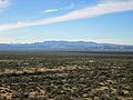
View of the Sierritas from the Santa Rita Experimental Range.


