Tohono Oʼodham Nation facts for kids
Quick facts for kids
Tohono Oʼodham Nation
|
|||
|---|---|---|---|
|
|||

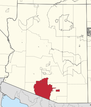
Location in Arizona
|
|||
| Tribe | Tohono O'odham | ||
| Country | United States | ||
| State | Arizona | ||
| Counties | Maricopa Pima Pinal |
||
| Established | 1874 (executive order) | ||
| Main expansions | 1882–1916 | ||
| First constitution | 1937 | ||
| Tripartite system | 1986 | ||
| Capital | Sells, Arizona | ||
| Subdivisions | 11 districts | ||
| Government | |||
| • Body | Tohono Oʼodham Legislative Council | ||
| Area | |||
| • Total | 11,300 km2 (4,400 sq mi) | ||
| Population
(2017)
|
|||
| • Total | 10,703 | ||
| • Density | 0.947/km2 (2.453/sq mi) | ||
| Time zone | MST/MDT | ||
| GDP | $23.6 Billion (2018) | ||
| Website | tonation-nsn.gov | ||
The Tohono Oʼodham Nation is the official government for the Tohono Oʼodham people. They are a Native American tribe in the United States. The Nation manages four separate areas of land. These lands together are about the size of Connecticut. They are the second largest Native American land holding in the U.S.
These lands are in the Sonoran Desert in south-central Arizona. They share a border with Mexico for about 74 miles (119 km). The Nation has 11 local areas called districts. Its government has three main parts, like the U.S. government. Sells is the biggest community and acts as the capital city. About 34,000 people are members of the Nation. Most of them live outside the main reservation lands.
Contents
History of the Tohono Oʼodham Nation
How the Nation's Land Grew
In 1874, U.S. President Ulysses S. Grant signed an order. This order created the San Xavier Indian Reservation. It was around the old Mission San Xavier del Bac. Later, in 1882, President Chester A. Arthur added more land. He created the Gila Bend Indian Reservation for the Tohono Oʼodham people.
A third reservation was made in 1916. Its main office was in Indian Oasis, now called Sells, Arizona. In 1937, the Tohono Oʼodham Nation, then known as the Papago Tribe of Arizona, adopted its first set of rules, called a constitution.
Changes and New Lands
In 1960, a dam was built on the Gila River. This dam caused floods that covered about 10,000 acres (40 km²) of the Gila Bend Indian Reservation. This flooded area included a farm and several communities. The people living there had to move. They went to a new place called San Lucy Village.
In 1986, the people of the three reservations voted for a new constitution. They changed the tribe's name to the Tohono Oʼodham Nation. They also set up a government with three parts, like the U.S. government. In the same year, the U.S. government and the Nation agreed on a deal. The Nation gave up some legal claims. In return, they received $30 million and the right to add new land to their reservation.
Land Purchases and Challenges
In 2009, the tribe bought about 135 acres (0.55 km²) near Glendale, Arizona. Some local groups were against developing this land. However, by 2014, the city of Glendale began talking with the Nation about their plans.
Also in 2009, the Nation bought 650 acres (2.6 km²) near Why, Arizona. They planned to create a new district for the Hia C-eḍ Oʼodham people. On October 30, 2012, a new tribal law created the Hia-Ced District. This made it the 12th district. But on April 25, 2015, people voted to end the Hia-Ced District. So, the Nation went back to having 11 districts.
The Tohono Oʼodham People
Most Tohono Oʼodham people live in the United States. A smaller number live across the border in northwestern Mexico. The Tohono Oʼodham Nation speaks a language called Oʼodham. It is one of the most spoken Native American languages in the U.S. Many people are Catholic. However, the Nation's schools also teach their native language and culture.
About 34,000 people are members of the Nation. Most of these members live off the reservations. The main reservation, the Tohono Oʼodham Indian Reservation, has about 11,000 residents. The San Xavier Indian Reservation has about 1,200 people. The Gila Bend Indian Reservation has around 1,700 people. Florence Village has about 195 people. The remaining 14,600 members live in other places.
Geography of the Nation's Lands
The Nation's lands are in the Sonoran Desert in south-central Arizona. This area has many parallel mountains and valleys. The plants here are typical for the Sonoran Desert. You can see saguaro cactus, cholla, prickly pear, palo verde, velvet mesquite, whitethorn acacia, desert ironwood, and willow.
The landscape also has wide plains and mountains. These include the Quinlan and Baboquivari Mountains. Here you'll find Kitt Peak, home to the Kitt Peak National Observatory and its telescopes. Baboquivari Peak is also in this area.
Sells, Arizona is the largest community and the capital. The Tohono Oʼodham Nation has four separate land areas. Together, they cover about 2.8 million acres (11,300 km²). This makes it the second largest Native American land holding in the United States.
The largest land area is the main reservation, over 2.7 million acres (10,900 km²). The San Xavier reservation is the second largest, with about 71,095 acres (287.71 km²) just south of Tucson. The Gila Bend Indian Reservation is 473 acres (1.91 km²). Florence Village is 25 acres (0.10 km²).
After the 1853 Gadsden Purchase, the Tohono Oʼodham lands were split between the United States and Mexico. The Nation's southern border is directly along the Mexico–United States border for about 74 miles (119 km). There is no reservation for the Tohono Oʼodham people in Mexico.
How the Nation is Governed
The Tohono Oʼodham Nation is divided into 11 local districts. Nine of these districts are on the main Tohono Oʼodham Indian Reservation. The Gila Bend and San Xavier reservations, which are separate, make up the other two districts.
The government of the Tohono Oʼodham Nation has three parts:
- Executive Branch: This includes the chairman and vice-chairman.
- Judicial Branch: This is made up of judges and courts.
- Legislative Branch: This is the tribal council, with representatives from each district.
Overall, the Tohono Oʼodham Nation is led by a chairman and a legislative council. Both are chosen by democratic elections. All the reservations are managed by a central government located in Sells. As of 2019, the Nation's Chairman is Ned Norris, Jr. and the Vice Chair is Wayvalene Romero. The Chief Justice is Violet Lui-Frank, and the Legislative Chairman is Timothy Joaquin Gu Achi.
The Tohono Oʼodham Nation runs its own services. These include:
- Tohono Oʼodham Community College
- A fire department
- Several recreation centers
- A health center
- A nursing home
- A public utilities company
Economy and Jobs
The Tohono Oʼodham Nation gets money from many different places. Some people still farm or raise animals for food. The tribe also sells and leases rights to copper minerals found on their land.
A major source of money and jobs comes from the three casinos the tribe operates. The Tohono Oʼodham Utility Authority is a tribal company started in 1970. It provides electricity and water services to the reservation. Basket weaving is also an important economic activity. The tribe makes more baskets than almost any other tribe in the United States.
 | Frances Mary Albrier |
 | Whitney Young |
 | Muhammad Ali |


