Waterman Mountains facts for kids
Quick facts for kids Waterman Mountains |
|
|---|---|
 |
|
| Highest point | |
| Peak | Waterman Peak |
| Elevation | 3,808 ft (1,161 m) |
| Dimensions | |
| Length | 6 mi (9.7 km) |
| Width | 7 mi (11 km) |
| Geography | |
| Country | United States |
| State | Arizona |
| Region | (north)-Sonoran Desert |
| District | Pima County, Arizona |
| Settlement | Silver Bell, AZ |
| Range coordinates | 32°21′34″N 111°28′37″W / 32.359516°N 111.477057°W |
| Borders on | Silver Bell Mountains-N Avra Valley–Marana, Arizona-E Aguirre Valley-SW |
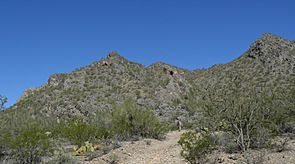
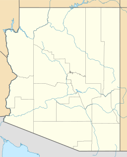
The Waterman Mountains are a small group of mountains in Pima County, United States. They are part of the Ironwood Forest National Monument, a special protected area.
One interesting tree found here is the elephant tree (Bursera microphylla). These trees have unique, twisted trunks that look like they're bending in many directions. Sadly, many of them froze during a very cold winter in 2011.
About the Waterman Mountains
The Waterman Mountains are not very large. They connect with the southern part of the Silver Bell Mountains. To the south, they are next to the Roskruge Mountains.
The highest point in this mountain range is Waterman Peak. It stands tall at 3,808 feet (1,161 meters) above sea level.
Plants of the Past: Prehistoric Ecology
Scientists have studied what the area around the Waterman Mountains looked like long, long ago. They have learned about the plants that grew here during the last glacial period, also known as the last Ice Age.
By looking at old pollen, they found that the main trees back then were Utah juniper (Juniperus osteosperma), single-leaf pinyon (Pinus monophylla), and redberry juniper (Juniperus pinchotii). Other plants like canotia (Canotia holacantha) and Monardella arizonica also grew in the area.
 | George Robert Carruthers |
 | Patricia Bath |
 | Jan Ernst Matzeliger |
 | Alexander Miles |


