
Sasabe, Arizona facts for kids
Quick facts for kids
Sasabe, Arizona
|
|
|---|---|

Sasabe, Arizona
Location in Arizona

Sasabe, Arizona
Location in the United States
|
|
| Country | United States |
| State | Arizona |
| County | Pima |
| Elevation | 3,537 ft (1,078 m) |
| Time zone | UTC-7 (MST (no DST)) |
| Area code(s) | 520 |
| FIPS code | 04-64520 |
| GNIS feature ID | 10961 |
Sasabe (which means Ṣaṣawk in the Tohono O'odham language) is a small village in southern Pima County, Arizona, United States. It is located right next to the border with Mexico. Sasabe is part of the Altar Valley and has a few important places.
This small community has a border crossing, a school, a guest ranch, and a general store. There is also a post office that serves the area. In 2010, about 54 people lived in the Sasabe area.
History of Sasabe
Sasabe gets its name from the Tohono Oʼodham people. Their language calls it "head valley." The first post office in Sasabe opened in 1905. This helped the small community grow and connect with other places.
Rancho de la Osa: A Historic Guest Ranch
Sasabe is well-known for its old and famous Rancho de la Osa guest ranch. This ranch used to be a huge Spanish land grant, covering about three million acres. Some parts of the ranch buildings are thought to be from the late 1600s.
The Rancho de la Osa guest ranch started welcoming visitors in 1921. Many important people have stayed there, including former Presidents Franklin Roosevelt and Lyndon Johnson. It's a place where people can experience history and the beauty of Arizona.
Sasabe Border Crossing
Sasabe has a small border crossing point between the United States and Mexico. In 2011, about 165 cars, trucks, or people crossed the border here each day. The town of Sasabe, Arizona, is smaller than its neighbor across the border, El Sásabe, in Sonora, Mexico. El Sásabe is known for making bricks from burnt adobe.
Sasabe School Life
The local school in Sasabe is very important to the community. During the 2018–2019 school year, the school taught 28 children. These students were in grades from kindergarten through eighth grade.
Geography and Nature Around Sasabe
Sasabe is located on a dry, gently sloping sandy plain. You can see scattered shrubs and clumps of grass around the area. The land north and east of Sasabe is part of the Buenos Aires National Wildlife Refuge. This refuge is a protected area for wildlife.
In 2006, about 3,500 acres of the refuge near the Mexican border were closed to the public. This was done to help manage issues with unauthorized border crossings.
Sasabe's Climate and Weather
Sasabe has a semi-arid climate. This means it has dry weather. Winters are usually mild, but summers can be very hot.
| Climate data for Sasabe, Arizona, 1991–2020 normals, extremes 1959–present | |||||||||||||
|---|---|---|---|---|---|---|---|---|---|---|---|---|---|
| Month | Jan | Feb | Mar | Apr | May | Jun | Jul | Aug | Sep | Oct | Nov | Dec | Year |
| Record high °F (°C) | 85 (29) |
91 (33) |
92 (33) |
100 (38) |
104 (40) |
113 (45) |
111 (44) |
109 (43) |
105 (41) |
102 (39) |
93 (34) |
84 (29) |
113 (45) |
| Mean maximum °F (°C) | 77.7 (25.4) |
79.5 (26.4) |
84.6 (29.2) |
91.1 (32.8) |
97.5 (36.4) |
105.2 (40.7) |
105.1 (40.6) |
102.0 (38.9) |
98.8 (37.1) |
94.4 (34.7) |
85.2 (29.6) |
78.3 (25.7) |
106.8 (41.6) |
| Mean daily maximum °F (°C) | 65.9 (18.8) |
67.1 (19.5) |
72.7 (22.6) |
79.7 (26.5) |
87.8 (31.0) |
97.0 (36.1) |
96.4 (35.8) |
94.0 (34.4) |
91.5 (33.1) |
84.0 (28.9) |
74.2 (23.4) |
65.2 (18.4) |
81.3 (27.4) |
| Daily mean °F (°C) | 50.6 (10.3) |
51.9 (11.1) |
56.6 (13.7) |
62.0 (16.7) |
69.2 (20.7) |
78.7 (25.9) |
81.5 (27.5) |
79.9 (26.6) |
76.1 (24.5) |
67.3 (19.6) |
57.8 (14.3) |
50.0 (10.0) |
65.1 (18.4) |
| Mean daily minimum °F (°C) | 35.4 (1.9) |
36.8 (2.7) |
40.6 (4.8) |
44.3 (6.8) |
50.6 (10.3) |
60.4 (15.8) |
66.7 (19.3) |
65.7 (18.7) |
60.8 (16.0) |
50.6 (10.3) |
41.3 (5.2) |
34.7 (1.5) |
49.0 (9.4) |
| Mean minimum °F (°C) | 25.6 (−3.6) |
26.9 (−2.8) |
30.9 (−0.6) |
34.4 (1.3) |
40.8 (4.9) |
49.6 (9.8) |
59.9 (15.5) |
60.3 (15.7) |
51.9 (11.1) |
39.6 (4.2) |
30.0 (−1.1) |
24.9 (−3.9) |
22.5 (−5.3) |
| Record low °F (°C) | 14 (−10) |
12 (−11) |
13 (−11) |
25 (−4) |
32 (0) |
39 (4) |
51 (11) |
49 (9) |
40 (4) |
27 (−3) |
22 (−6) |
14 (−10) |
12 (−11) |
| Average precipitation inches (mm) | 0.91 (23) |
1.16 (29) |
0.96 (24) |
0.46 (12) |
0.15 (3.8) |
0.35 (8.9) |
2.77 (70) |
3.20 (81) |
1.62 (41) |
0.50 (13) |
0.72 (18) |
1.44 (37) |
14.24 (362) |
| Average snowfall inches (cm) | 0.0 (0.0) |
0.0 (0.0) |
0.6 (1.5) |
0.0 (0.0) |
0.0 (0.0) |
0.0 (0.0) |
0.0 (0.0) |
0.0 (0.0) |
0.0 (0.0) |
0.0 (0.0) |
0.0 (0.0) |
0.0 (0.0) |
0.6 (1.5) |
| Average precipitation days (≥ 0.01 inch) | 2.5 | 2.9 | 2.4 | 1.2 | 0.5 | 1.1 | 7.7 | 8.5 | 4.4 | 1.6 | 1.5 | 2.9 | 37.2 |
| Average snowy days (≥ 0.1 inch) | 0.0 | 0.0 | 0.1 | 0.0 | 0.0 | 0.0 | 0.0 | 0.0 | 0.0 | 0.0 | 0.0 | 0.0 | 0.1 |
| Source: NOAA | |||||||||||||
Images for kids
-
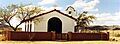
Church in Sasabe
-
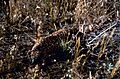
Gila Monster, Buenos Aires National Wildlife Refuge

See also
 In Spanish: Sasabe para niños
