
Mount Wrightson facts for kids
Quick facts for kids Mount Wrightson |
|
|---|---|

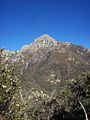
Mount Wrightson from Madera Canyon.
|
|
| Highest point | |
| Elevation | 9,456 ft (2,882 m) NAVD 88 |
| Prominence | 4,578 ft (1,395 m) |
| Geography | |
| Location | Santa Cruz County, Arizona, U.S. |
| Parent range | Santa Rita Mountains |
| Topo map | USGS Mount Wrightson (AZ) |
| Climbing | |
| Easiest route | Walk up (class 1) |
Mount Wrightson is a tall peak in the Santa Rita Mountains in southern Arizona, United States. It stands 9,456-foot (2,882 m) high. This mountain is part of the Coronado National Forest.
The mountain was named after William Wrightson. He was a miner and business owner in the area. He passed away in 1865 during a conflict.
Contents
About Mount Wrightson
Mount Wrightson is the highest point in the Santa Rita Mountains. It is also the tallest peak in the Tucson area. The mountain is about 40 miles (64 km) southeast of Tucson.
Its unique pyramid shape can be seen from many places. You can spot it across southeastern Arizona and even parts of Sonora, Mexico. From the top, you can see nearly 7,000 feet (2,100 m) down to Tucson. The views from its bare peak are truly amazing!
Plants on Mount Wrightson
Mount Wrightson is home to many different kinds of plants. As you go up the mountain, you will see various types of plant life.
Types of Plants
- Grassy areas: Lower parts of the mountain have open grassy areas.
- High desert chaparral: This includes tough shrubs that grow in dry, rocky places.
- Mixed conifers: These are cone-bearing trees like Arizona, Apache, and Chihuahua pines.
- Other trees: You might also see Arizona madrone trees, aspens, and oak brush.
- Near the summit: Closer to the top, you'll find Douglas fir and ponderosa pine trees.
Animals on Mount Wrightson
Mount Wrightson is a great place to spot wildlife. Many different animals live here, from birds to larger mammals.
Wildlife You Might See
- Birds: High up near the peak, you can often see scrub jays and ravens.
- Deer: Coues white-tailed deer are common in the forest.
- Bears: Black bears also live on the mountain.
- Mountain Lions: While rare, mountain lions are sometimes seen.
Hiking Mount Wrightson
Mount Wrightson is a popular spot for hiking. There are a few trails that lead to the summit.
Popular Hiking Trails
- Old Baldy Trail: This is the shortest way to the top. It's a steady climb of over 4,000 feet (1,200 m) over 5.4 miles (8.7 km).
- Super Trail: This trail is not as steep as Old Baldy. However, it is much longer at 8.1 miles (13.0 km).
Both of these trails meet at a spot called Josephine Saddle. This saddle is at 7,080 feet, 2,160 m elevation. Hikers can use one trail for the lower part and the other for the upper part.
Getting to the Trailhead
To reach the start of the trails, take exit 63 off of I-19 south of Tucson. Then, turn east towards Continental. Next, turn right onto Whitehouse Canyon Road. Follow this road until it becomes Madera Canyon Road. You will find plenty of parking at the end of the road, where the trailhead is located.
Important Hiking Information
There are several natural springs on the mountain. These include Bog Spring, Sprung Spring, Kent Spring, and Baldy Spring. Even with these springs, it's very important to bring plenty of water. Also, always be aware of the wildlife around you. This area is known for bird watching, and black bears are often seen.
About two miles into the hike, you will reach a saddle. This spot offers an easy day hike with amazing views of the peak. Here, you will find a Boy Scout Memorial. It was put up to remember three scouts who sadly passed away in a storm on Mount Wrightson on November 15, 1958. The plaque mentions David Greenberg (age 12), Mike Early (age 16), and Michael J. Lanoue (age 13).
The very last part of the climb to the summit faces north. In winter, this section can become icy. You might need special gear to cross it safely during colder months.
In 2005, a large forest fire called the "Florida Fire" happened in this area. It affected a big part of the forest, especially sections of the hiking trails.
Images for kids
-
Mount Wrightson from Jack Mountain.
-
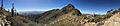
Mount Wrightson viewed from the south, at one of the main saddles.
-
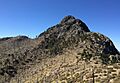
Looking up, close to the summit of Wrightson (April 2016).


