
Oklahoma Panhandle facts for kids

The Oklahoma Panhandle is a long, narrow strip of land in the far western part of the state of Oklahoma. It includes three counties: Cimarron County, Texas County, and Beaver County. Its unique name comes from its shape, which looks like the handle of a cooking pan.
Contents
History of the Panhandle
No Man's Land
The Oklahoma Panhandle was once known as "No Man's Land." This area was not part of any state or territory for many years. It was a strip of land 34 miles wide and 167 miles long. This land was left over after different treaties and land deals were made.
Why it was "No Man's Land"
In 1819, the Adams–Onís Treaty set the northern border of Texas at 42 degrees north latitude. Then, in 1845, when Texas became a state, it could not be a slave state and also own land north of the Missouri Compromise line (36°30′ north latitude). So, Texas gave up this northern strip of land.
Later, in 1850, the Compromise of 1850 officially made this strip of land part of the United States. However, it was not given to any existing territory. This meant it had no government or laws, earning it the name "No Man's Land."
Life in No Man's Land
For many years, the area was a haven for outlaws and people trying to avoid the law. There were no sheriffs or courts. Despite this, some people, like ranchers, moved into the area. They used the land for grazing their cattle.
Settlers and land claims
In the 1880s, more settlers began to arrive. They hoped to claim land under the Homestead Act. However, since there was no official government, their land claims were not always secure. This led to many disputes and conflicts over who owned what land.
Becoming part of Oklahoma
In 1890, the Oklahoma Organic Act finally gave the "No Man's Land" a proper government. It became part of the new Oklahoma Territory and was named Beaver County. This was a big step towards bringing law and order to the area.
From territory to state
When Oklahoma became a state in 1907, Beaver County was divided into the three counties we know today: Cimarron, Texas, and Beaver. These three counties together form the Oklahoma Panhandle.
Geography and Climate
The Oklahoma Panhandle is mostly flat grassland. It is part of the Great Plains region of the United States. The climate here can be very extreme. Summers are hot, and winters can be very cold. The area also experiences strong winds and occasional dust storms.
Water sources
Water is scarce in the Panhandle. The Beaver River (also known as the North Canadian River) flows through the area. Farmers often rely on underground water sources, like the Ogallala Aquifer, for their crops and livestock.
Economy and Culture
The economy of the Oklahoma Panhandle is mainly based on agriculture.
Farming and ranching
Farmers grow crops like wheat and sorghum. Ranching, especially raising cattle, is also very important. The wide-open spaces are perfect for large ranches.
Energy production
The Panhandle also has natural gas and oil reserves. This means that energy production is another important part of the local economy.
Local culture
Life in the Panhandle is often quiet and peaceful. The communities are small and close-knit. People living here often have a strong connection to the land and a proud history of self-reliance.
Images for kids
-
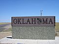
State welcome sign on the New Mexico border of the Panhandle
-
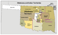
Map of Oklahoma Territory, Indian Territory and the "neutral strip"
-
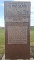
No Man's Land Monument, U.S. Highway 64 east of Gate (Oklahoma Panhandle)
-
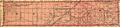
Beaver County encompassed the whole Panhandle from 1890 until statehood.


See also
 In Spanish: Mango de Oklahoma para niños
