
Panhandle facts for kids

A panhandle is a special word used in geography. It describes a narrow strip of land that sticks out from a larger area, like the handle of a frying pan. This strip of land is connected to its main country or region on only one side. On its other sides, it is surrounded by different countries or regions.
What is a Panhandle?
Imagine a country or a state shaped like a big blob. Now, picture a long, skinny part of that blob reaching far away from the main body. That's a panhandle! These unique shapes often happen because of old border agreements, natural features like rivers, or historical events that shaped how land was divided. They can create interesting challenges for the people living there, as they might be far from the main government or major cities of their own area.
Famous Panhandles Around the World
Many places around the world have panhandles. They are often well-known parts of their states or countries. Here are a few examples:
- The Florida Panhandle is the northwestern part of the U.S. state of Florida. It stretches along the Gulf of Mexico.
- The Oklahoma Panhandle is a long, narrow strip of land in the northwestern part of the U.S. state of Oklahoma. It borders Texas, Kansas, Colorado, and New Mexico.
- The Alaska Panhandle is the southeastern part of Alaska. It is a long, narrow strip of islands and mainland that runs along the coast.
- The Caprivi Strip is a panhandle in Namibia, a country in Africa. It stretches eastward from the main part of Namibia, allowing access to the Zambezi River.
Images for kids
-
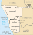
Map of Namibia showing the Caprivi Strip in the country's northeast.
-
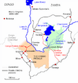
A map of the Congo Pedicle
-
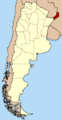
Misiones Province within Argentina
-
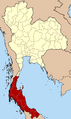
The 14 provinces of Thailand forming the salient of Southern Thailand.
-
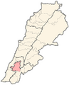
Location of Nabatieh District within Nabatieh Governorate, Lebanon.
-
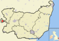
Location of Newmarket (shown as red dot) within Suffolk, England
-
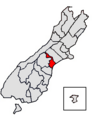
Location of Timaru District within New Zealand's South Island. The Waitaki District is parallel with it, a little further south.


