Ogallala Aquifer facts for kids


The Ogallala Aquifer (pronounced oh-gə-LAH-lə) is a huge underground water supply. It is found beneath the Great Plains in the United States. This aquifer is like a giant sponge made of sand, silt, clay, and gravel. It holds water deep below the ground.
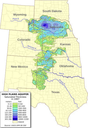
It is one of the largest aquifers in the world. It stretches across about 174,000 square miles. This includes parts of eight states: South Dakota, Nebraska, Wyoming, Colorado, Kansas, Oklahoma, New Mexico, and Texas. The aquifer got its name in 1898 from a geologist named N. H. Darton. He named it after the town of Ogallala, Nebraska.
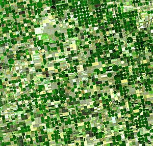
Farmers began using a lot of water from the Ogallala Aquifer after World War II. They used new methods like center pivot irrigation. This allowed them to pump water from deep underground. Today, about 27% of all irrigated farmland in the U.S. is over this aquifer. It provides about 30% of the groundwater used for irrigation in the country.
However, the aquifer is in danger of being used up too quickly. It also faces pollution. Since 1950, farming has reduced the amount of water in the aquifer by about 9%. If it runs out, it would take over 6,000 years to fill up naturally from rainfall. The aquifer also provides drinking water for 82% of the 2.3 million people living in the High Plains area.
Contents
What is the Ogallala Aquifer like?
The material that makes up the aquifer was laid down millions of years ago. This happened between two and six million years ago. At that time, the southern Rocky Mountains were still growing. Rivers and streams flowed from the mountains towards the east.
These rivers carried sand, gravel, and other sediments. They filled up old valleys and channels. Eventually, these sediments covered the entire area where the aquifer is today. This formed the Ogallala Formation, which holds the water. This process is similar to how modern rivers like the Kansas River work. But it happened over a much longer time and created a very deep layer.
The depth of the Ogallala Aquifer changes. It is deepest where it filled ancient valleys. The deepest part is about 1,200 feet (300 meters) deep. It is generally deeper in the northern parts of the plains. The water itself can be found from almost 400 feet below the surface in the north. In much of the south, it is between 100 and 200 feet deep.
New fresh water enters the aquifer very slowly. This means much of the water inside it is very old. Some of it dates back to the most recent ice age or even earlier. A layer of rock that water cannot easily pass through lies above the aquifer. This, along with a dry climate, stops much new water from getting in.
Water in the Ogallala Aquifer generally flows from west to east. It moves at about one foot per day. The water quality is best in the northern part of the aquifer. It is not as good in the southern part. Over the last 60 to 70 years, human activities like irrigation have caused more pollution. This includes higher levels of nitrates. While nitrate levels are usually safe, they are slowly increasing. This could affect the aquifer's future water supply.
How much water is in the Ogallala Aquifer?
An aquifer is like an underground storage tank for water. Water in aquifers is a renewable resource. However, it takes a very long time for these reserves to fill up again. The USGS has studied the aquifer. They want to know how much water is coming in (from rain) and how much is leaving (from pumping and flowing into rivers). They also track how the total amount of water changes.
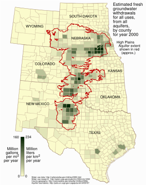
In 2005, the USGS estimated the aquifer held about 2.9 billion acre-feet of water. An acre-foot is the amount of water needed to cover one acre of land one foot deep. In 2000, farmers used about 26 cubic kilometers of water from the Ogallala for irrigation. Since major pumping began in the late 1940s, the aquifer has lost a huge amount of water. This loss is equal to about 85% of the water in Lake Erie.
Many farmers in the Texas High Plains rely heavily on this groundwater. But now, they are starting to use less irrigated farming. This is because pumping costs have gone up. They also understand the dangers of pumping too much water.
How the aquifer gets refilled
Several things limit how fast the aquifer can refill. Much of the plains region is semi-dry. Strong winds cause surface water and rain to evaporate quickly. In many places, a hard layer of rock called caliche sits above the aquifer. This layer is almost waterproof. It stops much of the rain from reaching the aquifer below.
However, the soil in playa lakes is different. These small, temporary lakes do not have the caliche layer. This makes them one of the few places where the aquifer can refill. But when farmers destroy these playa lakes, less water can get into the aquifer. The dry climate also causes more evaporation. This increases the amount of caliche in the soil. Both of these things reduce how much water reaches the aquifer.
The amount of water refilling the aquifer varies. It ranges from about 0.024 inches per year in parts of Texas and New Mexico. It can be up to 6 inches per year in south-central Kansas.
How water leaves the aquifer

The areas above the Ogallala Aquifer are very important for farming in the United States. Farmers raise livestock and grow crops like corn, wheat, and soybeans. These areas do not get much rain. They also do not always have rivers for water. So, successful large-scale farming here depends on pumping groundwater for irrigation.
Early settlers in the dry High Plains often had their crops fail. This was due to periods of drought. The worst time was the Dust Bowl in the 1930s. After World War II, a new farming method called center-pivot irrigation became popular. This changed the High Plains into one of the most productive farming regions in the world.
Changes in water levels
Groundwater levels drop when more water is pumped out than can be refilled. In some places, the water level dropped more than 5 feet (1.5 meters) per year. This happened when the most water was being pumped. In extreme cases, farmers had to dig their wells deeper to reach the falling water. In recent years, people have become more aware of how important the aquifer is. This has led to more news coverage about it.
Farmers have started using methods to save water. These include terracing and crop rotation. They also use more efficient irrigation methods like center pivot and drip irrigation. They are also farming smaller areas. These efforts have helped slow down the aquifer's depletion. However, water levels are still generally dropping. This is true in places like southwestern Kansas and the Texas Panhandle. In other areas, like parts of Nebraska, water levels have actually risen since 1980.
The center-pivot irrigator was called the "villain" in a 2013 New York Times article. It talked about how parts of the Ogallala Aquifer were drying up. Sixty years of intense farming using these huge irrigators has emptied parts of the aquifer. It would take hundreds or thousands of years of rain to replace the lost water. In Kansas, in 1950, about 250,000 acres were irrigated. With center-pivot irrigation, nearly three million acres became irrigated. In some parts of the Texas Panhandle, the water has completely drained away. "Large areas of Texas farmland over the aquifer can no longer be irrigated. In west-central Kansas, up to a fifth of the irrigated farmland has already gone dry."
The center-pivot irrigation system is actually very efficient. It helps save water. But by 2013, as these systems got better, farmers planted more crops. They irrigated more land and grew crops that needed more water. This is an example of the Jevons Paradox. One way to use less groundwater is to use treated recycled water for irrigation. Another way is to grow crops that need less water, like sunflowers.
Some rivers, like the Platte, flow below the aquifer's water level. This means the rivers receive water from the aquifer. They carry it away from the region instead of refilling the aquifer. The $46.1-million Optima Lake dam in western Oklahoma became useless. This happened because the dropping aquifer level greatly reduced the flow of the Beaver River. This river was supposed to be the lake's water source.
Faster water loss
The amount of water lost from the aquifer between 2001 and 2008 was huge. It was about 32% of all the water lost during the entire 20th century. In the United States, the biggest users of aquifer water are farms and oil/coal companies. "The total loss of groundwater in the United States sped up in the late 1940s. It continued at a steady rate through the end of the century." This loss has bad effects on the environment. It also harms the long-term supply of groundwater for the nation's water needs.
According to Matthew Sanderson, a professor at Kansas State University, this problem is made worse by farming support programs. Also, U.S. tax laws encourage too much spending on water-using technology. This is like a "treadmill of production." This is joined by a "treadmill of protection." This water conservation system delays real long-term water saving. It protects the water interests of key industries in the short term. Robertson suggests changes to federal policies. These changes would give more reasons to save groundwater. For example, changes to the Conservation Reserve Program. Also, states could add more rules on water use.
Since the 1940s, pumping from the Ogallala has lowered the aquifer by over 300 feet (90 meters) in some areas. Farmers have tried to rely less on irrigated water. Better farming methods allow them to grow much more food. They use about the same amount of water as they did forty years ago. Still, the aquifer lost a third of its total 20th-century depletion between 2001 and 2011.
The Ogallala is mainly refilled by rainwater. But only about one inch of rain actually reaches the aquifer each year. Rainfall in most of the Texas High Plains is very little. Evaporation is high, and water seeps into the ground slowly.
In the 1990s, the aquifer held about three billion acre-feet of groundwater. This water was used for crops and drinking. But the demand for water is greater than how fast it can refill. The water level is dropping especially in Texas and New Mexico. Continuing to use the aquifer this way is "troublesome and needs a major rethink," says historian Paul H. Carlson. He is a professor-emeritus from Texas Tech University in Lubbock.
Saving the Ogallala Aquifer
Since 2010, the North Plains Groundwater Conservation District has been working to save water. This district covers eight counties north of Amarillo. They offer a $300,000 yearly project to help farmers save water. Farmers in this project grow corn using just over half the water they normally would. Or, they plant their crops several weeks later than usual. They use pivot sprinklers, which are less expensive than drip irrigation. According to Steve Walthour, the district manager, saving water is very important. This is because the aquifer's levels are dropping.
A local non-profit group called Ogallala Commons also works to save the aquifer. They support local communities and work to protect the aquifer and the surrounding area.
In 2013, eleven farmers joined the conservation program. Some planted in dry soil instead of watered soil. They also left more space between plants. This technique helps the soil hold moisture longer. Soil sensors help farmers get exact information about how much moisture their crops have. Farmers want to save water because of the district's rules on taking water from the aquifer. The United States Geological Survey found that the water level in the aquifer has dropped more in Texas than in any other state in the basin.
Farmers can pump water from the aquifer on their own land for free. Pumping costs are low because natural gas, the fuel used, is cheap. The North Plains district first set limits on pumping in 2005. They made the rules stricter four years later. Some wells now need to have meters. Another challenge for the district is that higher crop prices have made some farmers plant more fields. This further increases the use of water from the aquifer.
See also
 | John T. Biggers |
 | Thomas Blackshear |
 | Mark Bradford |
 | Beverly Buchanan |


