Beaver River (Oklahoma) facts for kids
Quick facts for kids Beaver River |
|
|---|---|

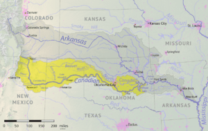
Map of the Canadian River watershed showing the Beaver River
|
|
| Country | United States |
| States | Oklahoma, Texas |
| Physical characteristics | |
| Main source | Cimarron County, Oklahoma 36°35′50″N 102°52′05″W / 36.5972471°N 102.867978°W |
| River mouth | North Canadian River Woodward County, Oklahoma 1,952 ft (595 m) 36°35′20″N 99°30′06″W / 36.5889236°N 99.5017789°W |
| Length | 280 mi (450 km) |
| Basin features | |
| Basin size | 11,690 square miles (30,300 km2) |
The Beaver River is a river in western Oklahoma and northern Texas, USA. It is about 280 miles (451 km) long. This river is a tributary (a smaller stream that flows into a larger one) of the North Canadian River. The Beaver River's watershed (the area of land where all water drains into the river) covers about 11,690 square miles (30,280 km²). This area includes most of the Oklahoma Panhandle and reaches into northeastern New Mexico.
Contents
Where Does the Beaver River Flow?
The Beaver River starts in Cimarron County, Oklahoma. It forms when two smaller streams, Corrumpa Creek and Seneca Creek, join together. From there, it generally flows towards the east.
The river dips south for about 15 miles (24 km) through Sherman County, Texas. Then, it returns to Oklahoma. It flows through several counties: Texas, Beaver, Harper, Ellis, and Woodward.
The Beaver River flows north of the city of Guymon. It also goes through the Optima Lake area. Near the dam, Coldwater Creek joins it. The river then flows through the town of Beaver and passes north of Fort Supply. Finally, northeast of Fort Supply, the Beaver River meets Wolf Creek. When these two rivers join, they form the North Canadian River in the Hal and Fern Cooper Wildlife Management Area.
Why Did the River's Name Change?
For many years, the Beaver River was sometimes called the "North Canadian River." This was even true for one of its starting streams, Corrumpa Creek. The U.S. federal government used this name from 1914 to 1970.
In 1914, the United States Board on Geographic Names (USBGN) decided that the North Canadian River included both the Beaver River and Corrumpa Creek. "Beaver River" was just a different name for part of it.
However, in 1970, the USBGN changed its mind. They decided that the Beaver River officially starts where Corrumpa Creek and Seneca Creek meet. It ends where it joins Wolf Creek to form the North Canadian River. The USBGN lists other old names for the river too, like "Beaver Creek" and "North Fork Canadian River."
Does the Beaver River Always Flow?
The Beaver River is known as an intermittent river. This means it does not always have water flowing in it. Sometimes it flows, and sometimes it's dry.
In the past, the river had big floods. For example, in October 1923, there was a huge flood. In September 1941, the water flow increased a lot. The most recent big flow was in October 1965.
Today, the Beaver River and its smaller streams often flow only after it rains or snow melts. This is partly because the underground water source, the Ogallala Aquifer, has less water. This aquifer is a huge underground water supply for many Western states. People use a lot of this water for farming and drinking.
Before the Optima Lake dam was built (1937–1966), the river's flow near Guymon was about 32.2 cubic feet per second. But in the decade after the dam was built (1977-1987), it dropped to only 7 cubic feet per second. In the early 1990s, the flow was very low, less than one-fifth of 1 cubic foot per second.
A few small parts of the river, like McNees Crossing, always have water. But most of the river flows underground in the sand, except after heavy rain or snow. The area around the Beaver River in New Mexico, Oklahoma, and Texas usually gets less than 8 inches (20 cm) of rain each year.
Even though it's often dry, the Beaver River does sometimes flow for a long distance. For example, in April 2016, the river was flowing near Guymon. This happened after two days of very heavy rains.
What Are the Beaver River's Tributaries?
Many smaller streams, called tributaries, flow into the Beaver River. Here are some of the main ones, listed from west to east:
- Cienequilla Creek
- Sand Creek
- Tepee Creek
- Coldwater Creek
- Palo Duro Creek
- Willow Creek
- Elm Creek
- Home Creek
- Timber Creek
- Spring Creek
- Clear Creek
 | Tommie Smith |
 | Simone Manuel |
 | Shani Davis |
 | Simone Biles |
 | Alice Coachman |

