
Woodward County, Oklahoma facts for kids
Quick facts for kids
Woodward County
|
|
|---|---|

Woodward Federal Courthouse and Post Office
|
|

Location within the U.S. state of Oklahoma
|
|
 Oklahoma's location within the U.S. |
|
| Country | |
| State | |
| Founded | 1876 |
| Seat | Woodward |
| Largest city | Woodward |
| Area | |
| • Total | 1,246 sq mi (3,230 km2) |
| • Land | 1,242 sq mi (3,220 km2) |
| • Water | 3.7 sq mi (10 km2) 0.3%% |
| Population
(2020)
|
|
| • Total | 20,470 |
| • Density | 16.429/sq mi (6.343/km2) |
| Time zone | UTC−6 (Central) |
| • Summer (DST) | UTC−5 (CDT) |
| Congressional district | 3rd |
Woodward County is a county in the state of Oklahoma. In 2020, about 20,470 people lived there. The main town and county seat (where the county government is) is Woodward.
Woodward County is part of the Woodward, OK micropolitan area. This means it's a smaller city area that is important to the region.
The county was first called "N" County. It was much bigger than it is now. It included parts of what are today Harper, Ellis, and Woods counties. Before Oklahoma became a state, Woodward County was the westernmost part of the Cherokee Outlet. This was a large area of land once owned by the Cherokee Nation.
It's not fully known who the county was named after. The two main ideas are Brinton W. Woodward, a director for a railway, or Richard Woodward, a buffalo hunter.
Contents
History of Woodward County
In the 1800s, Woodward County was a busy path for military travel. This was important for protecting the frontier. In 1868, a place called Camp Supply was set up. It was a supply base for a military campaign against the Cheyenne people.
From 1876 to the 1880s, huge groups of cattle were moved through the county. This happened along the Great Western Trail. The cattle were moved from Texas all the way to Kansas.
Railroads Arrive
Railroads helped the area grow. The Southern Kansas Railway built a line through the region in 1886–1887. This railway later became part of the Atchison, Topeka and Santa Fe Railway. The town of Woodward started where this railroad crossed an old military road.
Later, another railway, the Wichita Falls and Northwestern Railway, built a line. This line went from Elk City through Sharon and Woodward. It also went to Fort Supply and Forgan between 1911 and 1912.
County Creation
In September 1893, the Cherokee Outlet was opened for new settlers. At this time, Woodward County was created as "County N" in Oklahoma Territory. It was much larger back then. On November 6, 1894, people voted to rename it Woodward County.
When Oklahoma became a state in 1907, the county's borders changed. The extra land was given to Harper, Ellis, and Woods counties.
Geography of Woodward County
Woodward County covers about 1,246 square miles. Most of this is land (1,242 square miles), and a small part (3.7 square miles) is water.
The Cimarron River forms part of the northern border. It also drains the northwest part of the county. The North Canadian River flows through the county from northwest to southeast. The southern part of the county drains into the Canadian River. Fort Supply Lake, which is on Wolf Creek, is also in Woodward County.
The county is part of the Osage Plains. It is also in a region called the Western Red Prairies. There are gypsum hills in the eastern and northwestern parts of the county. Gypsum is a soft mineral.
Two protected natural areas in the county are Alabaster Caverns State Park and Boiling Springs State Park. These parks offer cool caves and natural springs.
Neighboring Counties
- Dewey County (south)
- Ellis County (west)
- Harper County (northwest)
- Major County (east)
- Woods County (northeast)
Population Information
| Historical population | |||
|---|---|---|---|
| Census | Pop. | %± | |
| 1910 | 16,592 | — | |
| 1920 | 14,663 | −11.6% | |
| 1930 | 15,844 | 8.1% | |
| 1940 | 16,270 | 2.7% | |
| 1950 | 14,383 | −11.6% | |
| 1960 | 13,902 | −3.3% | |
| 1970 | 15,537 | 11.8% | |
| 1980 | 21,172 | 36.3% | |
| 1990 | 18,976 | −10.4% | |
| 2000 | 18,486 | −2.6% | |
| 2010 | 20,081 | 8.6% | |
| 2020 | 20,470 | 1.9% | |
| 2021 (est.) | 20,205 | 0.6% | |
| U.S. Decennial Census 1790-1960 1900-1990 1990-2000 2010 |
|||

In 2010, there were 20,081 people living in Woodward County. The county had about 16 people per square mile. Most people (86.7%) were white. About 2.8% were Native American, and 1.6% were black or African American. About 10.6% of the people were Hispanic or Latino. By 2020, the population grew slightly to 20,470 people.
There were 7,654 households in 2010. About 30% of these households had children under 18 years old. Many households (54%) were married couples living together. About 28% of households had people living alone. The average household size was about 2.46 people.
The population was spread out by age. About 24.3% of people were under 18. About 14.2% were 65 years or older. The average age in the county was 37 years.
Economy
Farming and raising cattle have always been very important to Woodward County's economy. Before Oklahoma became a state, these activities brought a lot of money to the area. Grains, especially wheat, were the biggest crops.
Another important crop was broomcorn, which grew well there. Factories in Woodward and Mooreland used broomcorn to make brooms. During World War I, castor beans were grown. These beans were processed into castor oil, which was used to lubricate airplane engines.
New Industries
Starting in the 1920s, other industries became more important. These included mining and extracting natural resources. People mined for salt, bentonite (a type of clay), and petroleum (oil).
Natural gas production started in 1956. In 1975, a plant was built near Woodward. This plant extracted iodine from the salty water found in oil fields. Soon, this plant supplied 14% of the iodine used in the United States!
Communities
City
- Woodward (county seat)
Towns
Unincorporated communities
Historic Places
Woodward County has several places listed on the National Register of Historic Places. These are important historical sites.
- Fort Supply
- Woodward
- L. L. Stine House
- Woodward Crystal Beach Park
- Woodward Federal Courthouse and Post Office
Images for kids
-
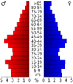
Age pyramid for Woodward County, Oklahoma, based on census 2000 data.
See also
 In Spanish: Condado de Woodward para niños
