Dewey County, Oklahoma facts for kids
Quick facts for kids
Dewey County
|
|
|---|---|

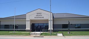
Dewey County Courthouse
|
|

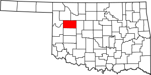
Location within the U.S. state of Oklahoma
|
|
 Oklahoma's location within the U.S. |
|
| Country | |
| State | |
| Founded | 1891 |
| Named for | George Dewey |
| Seat | Taloga |
| Largest city | Seiling |
| Area | |
| • Total | 1,008 sq mi (2,610 km2) |
| • Land | 999 sq mi (2,590 km2) |
| • Water | 8.8 sq mi (23 km2) 0.9%% |
| Population
(2020)
|
|
| • Total | 4,484 |
| • Density | 4.4484/sq mi (1.7175/km2) |
| Time zone | UTC−6 (Central) |
| • Summer (DST) | UTC−5 (CDT) |
| Congressional district | 3rd |
Dewey County is a county located in the western part of Oklahoma, a state in the United States. In 2020, about 4,484 people lived here. The main town and county seat is Taloga.
The county was first created in 1891 and was called "County D." Later, in 1898, people in the county voted to name it Dewey. This name honors Admiral George Dewey, a famous naval officer.
Contents
History of Dewey County
Long ago, the land that is now Dewey County was part of the territory of the Choctaw and Seminole Native American tribes. After the American Civil War, these tribes gave up some of their western lands to the United States. This area became known as the Leased District. Part of it was later set aside for the Cheyenne and Arapaho tribes.
Dewey County was officially formed in Oklahoma Territory in 1891. It was opened for new settlers on April 19, 1892. At first, it was just called "County D" by the U.S. Congress. It didn't get its current name until 1898, after a special election.
The first building used as the county courthouse in Taloga was made of wood. It served from 1909 until 1926. That's when the current, more permanent courthouse was built.
Geography and Nature
Dewey County covers a total area of about 1,008 square miles. Most of this area, about 999 square miles, is land. The remaining 8.8 square miles (less than 1%) is water.
Most of the county is part of the Gypsum Hills region. This area is known for its unique hills and gypsum rock formations. The western part of the county is in the High Plains region, which is flatter.
Two important rivers, the Canadian and North Canadian Rivers, flow through the county. Canton Lake is the only large lake in Dewey County. It was built on the Canadian River in 1966.
Main Roads in Dewey County
 U.S. Highway 60
 U.S. Highway 183
 U.S. Highway 270
 U.S. Highway 281
 State Highway 34
- State Highway 47
 State Highway 51
Neighboring Counties
- Woodward County (north)
- Major County (north)
- Blaine County (east)
- Custer County (south)
- Roger Mills County (southwest)
- Ellis County (northwest)
People of Dewey County
| Historical population | |||
|---|---|---|---|
| Census | Pop. | %± | |
| 1900 | 8,819 | — | |
| 1910 | 14,132 | 60.2% | |
| 1920 | 12,434 | −12.0% | |
| 1930 | 13,250 | 6.6% | |
| 1940 | 11,981 | −9.6% | |
| 1950 | 8,789 | −26.6% | |
| 1960 | 6,051 | −31.2% | |
| 1970 | 5,656 | −6.5% | |
| 1980 | 5,922 | 4.7% | |
| 1990 | 5,551 | −6.3% | |
| 2000 | 4,743 | −14.6% | |
| 2010 | 4,810 | 1.4% | |
| 2020 | 4,484 | −6.8% | |
| U.S. Decennial Census 1790-1960 1900-1990 1990-2000 2010 |
|||
In 2000, there were 4,743 people living in Dewey County. There were 1,962 households, and 1,336 families. The county had about 5 people per square mile.
Most people in the county were White (92.16%). About 4.64% were Native American. About 2.68% of the population identified as Hispanic or Latino.
About 26.70% of households had children under 18 living with them. The average household had 2.35 people. The average family had 2.93 people.
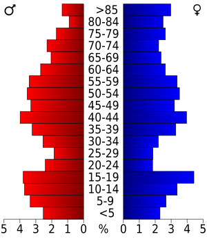
The median age in the county was 43 years old. About 23.30% of the population was under 18. About 21.00% were 65 years or older.
The median income for a household was $28,172. For families, it was $36,114. About 15.00% of the population lived below the poverty line.
Economy and Jobs
Since it was settled, the economy of Dewey County has mostly been about agriculture. Farmers grew crops like corn, cotton, wheat, and oats. Some also grew fruits like tomatoes, watermelons, and apples.
Raising livestock (animals like cattle, horses, and sheep) also became very important by the 1930s. These farming activities are still a big part of the county's economy today.
The county also has some natural resources. In the past, there was oil and gas production, especially in the 1940s and 1950s. Other resources found here include gypsum, clay, and sand. In 2000, there were only two manufacturing businesses in Dewey County that employed more than ten people.
Towns and Communities
City
Towns
Other Communities
Schools in Dewey County
Several school districts serve the students in Dewey County:
- Canton Public Schools
- Leedey Public Schools
- Sharon-Mutual Public Schools
- Seiling Public Schools
- Taloga Public Schools
- Thomas-Fay-Custer Unified Schools
- Vici Public Schools
See also
 In Spanish: Condado de Dewey (Oklahoma) para niños
 | James Van Der Zee |
 | Alma Thomas |
 | Ellis Wilson |
 | Margaret Taylor-Burroughs |


