Blaine County, Oklahoma facts for kids
Quick facts for kids
Blaine County
|
|
|---|---|

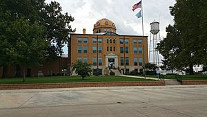
Blaine County Courthouse in Watonga
|
|

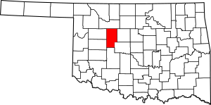
Location within the U.S. state of Oklahoma
|
|
 Oklahoma's location within the U.S. |
|
| Country | |
| State | |
| Founded | May 2, 1890 |
| Named for | James G. Blaine |
| Seat | Watonga |
| Largest city | Watonga |
| Area | |
| • Total | 939 sq mi (2,430 km2) |
| • Land | 928 sq mi (2,400 km2) |
| • Water | 10 sq mi (30 km2) 1.1%% |
| Population
(2020)
|
|
| • Total | 8,735 |
| • Density | 9.3/sq mi (3.6/km2) |
| Time zone | UTC−6 (Central) |
| • Summer (DST) | UTC−5 (CDT) |
| Congressional district | 3rd |
Blaine County is a county located in the U.S. state of Oklahoma. In 2020, about 8,735 people lived there. The main town and county seat is Watonga.
Blaine County was part of a special land opening in 1892. By the early 1900s, it had train lines, and by the 1930s, major highways. The county is named after James G. Blaine. He was an American politician and a Republican presidential candidate in 1884. He also served as Secretary of State for President Benjamin Harrison.
Contents
History of Blaine County
Blaine County was one of several counties created during the Land Run of 1892. Before the land run, in 1890, it was simply called county "C." When it was time to pick a real name in 1892, people wanted to honor military heroes. But a speaker suggested naming it after James G. Blaine, who had recently passed away. Most voters agreed, and the name Blaine was chosen.
Before the land run, the area was home to the Creek and Seminole tribes. They had been moved there by the government in the 1820s and 1830s. Later, the Cheyenne and Arapaho tribes were moved to this area from Colorado in 1869. This happened after treaties in 1866 took the land back from the Creek and Seminole.
The land run took place after each tribe member received 160 acres (0.65 km2) of land.
A post office was set up in Watonga, the county seat, in the same year as the land run. Train lines, like the Enid and Anadarko Railway, came through the county between 1901 and 1903. The Blaine County Courthouse was built in 1906.
The town of Geary also got a post office in 1892. It became an important farming trade center. By 1902, Geary had 2,561 people. Okeene was also started in 1892 and was surrounded by German farmers.
In 1904, Clarence Nash was born in Blaine County. He was the original voice of Disney's Donald Duck. In 1907, the county's population was 17,227. It grew to 17,960 in 1910 but then dropped to 15,875 by 1920.
Major U.S. highways came to Oklahoma in 1926. U.S. Highways 270 and 281 were built through Blaine County. The county was also on the Postal Highway as early as 1912. This later became part of U.S. Highway 66.
The county's population reached its highest point in 1930 with 20,452 people. During the Great Depression, programs like the Civilian Conservation Corps helped people find jobs. They also built Roman Nose State Park, which opened in 1937.
By the year 2000, the county had 11,976 people. However, between 2010 and 2020, the population dropped by 26.9 percent to 8,735. This was the biggest drop for any county in Oklahoma during that time. A big reason for this decline was the closing of a prison in 2010. The prison had been the largest employer in the county.
Geography of Blaine County
Blaine County covers about 939 square miles (2,430 km2). Most of this area, 928 square miles (2,400 km2), is land, and 10 square miles (26 km2) (1.1%) is water. The northeastern part of the county is on the edge of the Red Bed Plains. The southwestern part is in the Gypsum Hills. The North Canadian River flows through the county from northwest to southeast.
The county is home to Canton Lake. This is the largest lake in western Oklahoma.
The county seat, Watonga, holds an annual cheese festival in October. This festival celebrates the city's cheese factory.
Main Roads
 U.S. Highway 270
 U.S. Highway 281
 State Highway 3
 State Highway 8
 State Highway 51
 State Highway 58
Neighboring Counties
- Major County (north)
- Kingfisher County (east)
- Canadian County (southeast)
- Caddo County (south)
- Custer County (southwest)
- Dewey County (northwest)
People of Blaine County (Demographics)
| Historical population | |||
|---|---|---|---|
| Census | Pop. | %± | |
| 1900 | 10,658 | — | |
| 1910 | 17,960 | 68.5% | |
| 1920 | 15,875 | −11.6% | |
| 1930 | 20,452 | 28.8% | |
| 1940 | 18,543 | −9.3% | |
| 1950 | 15,049 | −18.8% | |
| 1960 | 12,077 | −19.7% | |
| 1970 | 11,794 | −2.3% | |
| 1980 | 13,443 | 14.0% | |
| 1990 | 11,470 | −14.7% | |
| 2000 | 11,976 | 4.4% | |
| 2010 | 11,943 | −0.3% | |
| 2020 | 8,735 | −26.9% | |
| U.S. Decennial Census 1790-1960 1900-1990 1990-2000 2010-2019 2020 |
|||
In 2000, there were 11,976 people living in Blaine County. About half of them lived in the county seat of Watonga. The county had about 13 people per square mile.
The people living in the county were mostly white (76.29%). There were also significant numbers of Native American (8.70%) and Black or African American (6.65%) residents. About 6.62% of the population was Hispanic or Latino.
The average age in the county in 2000 was 38 years old. About 24% of the people were under 18.
Economy of Blaine County
Southard, in central Blaine County, has some of the purest gypsum in the United States. It is home to the U.S. Gypsum Company, which is the largest industrial factory in the county.
Okeene is in the Cimarron Valley. Its economy is mostly based on farming, especially wheat and hay. Important businesses there include the Okeene Milling Company and Mountain Country Foods, which makes pet food. The Okeene Municipal Hospital and Clinic is a major medical center for northwest Oklahoma.
Towns and Cities
Cities
- Geary (partially in Canadian County)
- Watonga (county seat)
Towns
- Canton
- Greenfield
- Hitchcock
- Hydro (mostly in Caddo County)
- Longdale
- Okeene
Other Communities
- Eagle City
- Homestead
- Bickford (a ghost town)
- Bucher
- Darrow
- Southard
Schools in Blaine County
School districts in the county include:
- Canton Public Schools
- Cimarron Public Schools
- Fairview Public Schools
- Geary Public Schools
- Hinton Public Schools
- Hydro-Eakly Public Schools
- Lomega Public Schools
- Okeene Public Schools
- Thomas-Fay-Custer Unified Schools
- Watonga Public Schools
Historic Places (NRHP sites)
Many places in Blaine County are listed on the National Register of Historic Places. This means they are important historical sites.
|
|
See also
 In Spanish: Condado de Blaine (Oklahoma) para niños
 | James B. Knighten |
 | Azellia White |
 | Willa Brown |


