Canadian County, Oklahoma facts for kids
Quick facts for kids
Canadian County
|
|
|---|---|
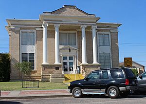
El Reno Carnegie Library
|
|
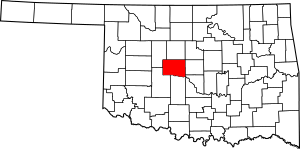
Location within the U.S. state of Oklahoma
|
|
 Oklahoma's location within the U.S. |
|
| Country | |
| State | |
| Founded | March, 1890 |
| Named for | Canadian River |
| Seat | El Reno |
| Largest city | Yukon |
| Area | |
| • Total | 906 sq mi (2,350 km2) |
| • Land | 897 sq mi (2,320 km2) |
| • Water | 9.0 sq mi (23 km2) 1.0%% |
| Population
(2020)
|
|
| • Total | 154,405 |
| • Density | 170.42/sq mi (65.80/km2) |
| Time zone | UTC−6 (Central) |
| • Summer (DST) | UTC−5 (CDT) |
| Congressional districts | 3rd, 4th |
Canadian County is a county in the U.S. state of Oklahoma. In 2020, about 154,405 people lived here. This makes it the fourth most populated county in Oklahoma.
The main town, or county seat, is El Reno. The county gets its name from the Canadian River. This river forms part of its southern border. The river might have been named after early French fur traders. They came from a place once called New France or Canada.
Canadian County is also part of the larger Oklahoma City area. This means it's connected to the big city's economy and culture.
Contents
History of Canadian County
Early Native American Settlements
In 1859, the United States government moved the Caddo Nation to this area. They came from a reservation in Texas. Showetat, the last Caddo chief, made his home here. He is seen as the first permanent resident of Canadian County. A town called Union City later grew near his camp.
The Wichita tribe also moved to this part of Indian Territory in 1861. Later, in 1869, the Cheyenne and Arapaho tribes arrived. They were moved from Colorado. An agency was set up in 1870 to help them. It was first called the Cheyenne-Arapaho Agency.
Forming the County
Canadian County was officially created in 1889. It was known as County Four of Oklahoma Territory. This happened when the Oklahoma Organic Act was passed. The county was named after the Canadian River.
European-American settlers arrived after a big event called the Land Run of 1889. This run happened on April 22, 1889. More land was opened up in a second land run in 1892. In 1902, more land became available for settlement. El Reno was chosen as the county seat. It won over other towns like Reno City and Frisco.
Geography and Rivers
Land and Water
Canadian County covers about 906 square miles. Most of this, 897 square miles, is land. Only about 9 square miles, or 1%, is water. The county is mostly flat, with some rolling hills. It's part of the Red Bed Plains region. A small part in the northwest is in the Gypsum Hills.
Important Rivers
Two main rivers flow through the county. These are the North Canadian River and the Canadian River. Both rivers flow from the northwest to the southeast.
The North Canadian River enters the county in the northwest. It flows southeast for about 76 miles. Its elevation drops as it flows. Smaller streams like Sixmile Creek and Mustang Creek feed into it.
The Canadian River enters the western part of the county. It flows southeast for about 45 miles. It then forms the southern border of the county. Dry Creek and Boggy Creek are some of its smaller branches.
The Cimarron River does not flow through the county. However, some of its smaller streams drain the northeastern part. These include Kingfisher Creek and Cottonwood Creek.
Neighboring Counties
Canadian County shares borders with several other counties:
- Kingfisher County (north)
- Logan County (northeast)
- Oklahoma County (east)
- Cleveland County (southeast)
- Grady County (south)
- Caddo County (southwest)
- Blaine County (northwest)
People and Population
| Historical population | |||
|---|---|---|---|
| Census | Pop. | %± | |
| 1890 | 7,158 | — | |
| 1900 | 15,981 | 123.3% | |
| 1910 | 23,501 | 47.1% | |
| 1920 | 22,288 | −5.2% | |
| 1930 | 28,115 | 26.1% | |
| 1940 | 27,329 | −2.8% | |
| 1950 | 25,644 | −6.2% | |
| 1960 | 24,727 | −3.6% | |
| 1970 | 32,245 | 30.4% | |
| 1980 | 56,452 | 75.1% | |
| 1990 | 74,409 | 31.8% | |
| 2000 | 87,697 | 17.9% | |
| 2010 | 115,541 | 31.8% | |
| 2020 | 154,405 | 33.6% | |
| 2023 (est.) | 175,829 | 52.2% | |
| U.S. Decennial Census 1790–1960 1900–1990 1990–2000 2010 |
|||
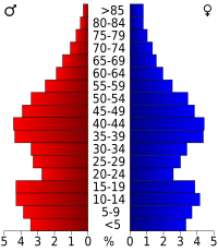
Canadian County has been growing steadily. In 2000, there were about 87,697 people. By 2020, the population had grown to 154,405. This shows a big increase in people choosing to live here.
The county is also very diverse. In 2021, many different groups made up the population. This includes people who are non-Hispanic white, African American, Native American, Asian, and multiracial. About 11% of the population was Hispanic or Latino.
Many families live in Canadian County. In 2000, about 40% of homes had children under 18. The average household had about 2.71 people. The average family had about 3.10 people.
Economy
Farming has been a very important part of the economy. It has supported the county since settlers first arrived in the late 1800s.
Transportation
Major Roads
Many important highways run through Canadian County. These roads help people travel and transport goods.
 I-40
I-40 I-344
I-344 I-40 Bus.
 US-81
US-81 US-270
 US-281
 SH-3
SH-3 SH-4
SH-4 SH-8
SH-8 SH-37
SH-37 SH-66
SH-66 SH-92
SH-92 SH-152
Airports
The county also has several airports:
- Clarence E. Page Municipal Airport: This airport is open to the public. It is about 15 miles west of Oklahoma City. Oklahoma City owns this airport.
- Sundance Airpark: This is another public airport. It is about 11 miles northwest of Oklahoma City. This airport is privately owned.
- El Reno Regional Airport: This airport is located in El Reno.
Communities
Cities
- El Reno (This is the county seat)
- Geary (Part of this city is in Blaine County)
- Mustang
- Oklahoma City (Most of this big city is in Oklahoma County)
- Piedmont (Part of this city is in Kingfisher County)
- Yukon
Towns
- Calumet
- Okarche (Part of this town is in Kingfisher County)
- Union City
Other Places
- Cedar Lake (This is a census-designated place)
Unincorporated Communities
These are smaller places that are not officially cities or towns:
- Concho
- Four Counties Corner (Used to be called Lockridge)
- Scott (Part of this community is in Caddo County)
Education
Canadian County has many school districts. They serve students from kindergarten through 12th grade.
K-12 School Districts
- Calumet Public Schools
- Cashion Public Schools
- Deer Creek Public Schools
- El Reno Public Schools
- Geary Public Schools
- Hinton Public Schools
- Lookeba-Sickles Public Schools
- Minco Public Schools
- Mustang Public Schools
- Okarche Public Schools
- Piedmont Public Schools
- Union City Public Schools
- Yukon Public Schools
Elementary School Districts
Some districts only serve elementary school students:
- Banner Public School
- Darlington Public School
- Maple Public School
- Riverside Public School
Historic Sites
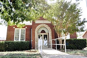
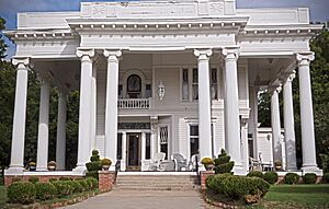
Many places in Canadian County are listed on the National Register of Historic Places. These sites are important for their history.
- Avant's Cities Service Station, El Reno
- Bridgeport Hill Service Station, Geary
- Bridgeport Hill-Hydro Route 66 Segment, Hydro
- Canadian County Jail, El Reno
- Carnegie Library, El Reno
- Czech Hall, Yukon
- Darlington Agency Site, El Reno
- El Reno High School, El Reno
- El Reno Hotel, El Reno
- El Reno Municipal Swimming Pool Bath House, El Reno
- Fort Reno, El Reno
- William I. and Magdalen M. Goff House, El Reno
- Jackson Conoco Service Station, El Reno
- Henry Lassen House, El Reno
- McGranahan Portion of the Chisholm Trail Roadbed, Yukon vicinity
- Meloy House, Mustang
- Mennoville Mennonite Church, El Reno
- Mulvey Mercantile, Yukon
- Red Cross Canteen, El Reno
- Richardson Building, Union City
- Rock Island Depot, El Reno
- Southern Hotel, El Reno
- West Point Christian Church, Yukon
- Yukon Public Library, Yukon
See also
 In Spanish: Condado de Canadian para niños
 | Sharif Bey |
 | Hale Woodruff |
 | Richmond Barthé |
 | Purvis Young |


