Grady County, Oklahoma facts for kids
Quick facts for kids
Grady County
|
|
|---|---|

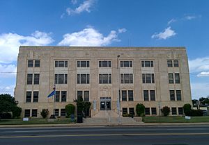
Grady County Courthouse in Chickasha (2014)
|
|

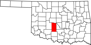
Location within the U.S. state of Oklahoma
|
|
 Oklahoma's location within the U.S. |
|
| Country | |
| State | |
| Founded | 1907 |
| Named for | Henry W. Grady |
| Seat | Chickasha |
| Largest city | Chickasha |
| Area | |
| • Total | 1,105 sq mi (2,860 km2) |
| • Land | 1,100 sq mi (3,000 km2) |
| • Water | 4.4 sq mi (11 km2) 0.4%% |
| Population
(2020)
|
|
| • Total | 54,795 |
| • Density | 49.588/sq mi (19.146/km2) |
| Time zone | UTC−6 (Central) |
| • Summer (DST) | UTC−5 (CDT) |
| Congressional district | 4th |
Grady County is a county in the state of Oklahoma. It's located in the central part of the state. In 2020, about 54,795 people lived there. The main city and county seat is Chickasha. The county was named after Henry W. Grady, who was a famous newspaper editor and speaker from the South.
Grady County is also part of the larger Oklahoma City area. This means it's connected to the big city for jobs and activities.
Contents
History of Grady County
Grady County has a rich history, especially with Native American tribes.
Early Tribal Lands
Long ago, this land was given to the Choctaw people. This happened through a special agreement called the Treaty of Dancing Rabbit Creek. Later, in 1837, the Chickasaw tribe joined the Choctaws in this area.
In 1855, a new treaty separated the two tribes. The Chickasaw Nation then gained control of a large area, which included most of what is now Grady County. Much of the county became part of Pickens County within the Chickasaw Nation.
Important Trails and Meetings
Before the Civil War, a famous explorer named Randolph B. Marcy created the California Road. This important trail passed right through this area. He even reported seeing villages of the Waco and Wichita tribes.
In 1858, a meeting was held between the Comanches, Wichita, Choctaw, and Chickasaw tribes. During this time, U.S. soldiers attacked a group of Comanches. This caused fear among the other tribes, and they sought safety at Fort Arbuckle.
After the Civil War, many tribes signed a peace agreement. This agreement was called the Camp Napoleon Compact. It helped different tribes unite and stand together.
Railroads Arrive
The first railroad arrived in this area in 1890. It was built to the town of Minco. Soon after, more tracks were laid, connecting towns like Chickasha, Ninnekah, and Rush Springs to other parts of the country. These railroads were very important for moving goods and people. They helped the towns grow and develop.
Becoming a State
In 1898, a law called the Curtis Act changed things for the Chickasaw Nation. It meant that their shared land was divided up. This was a step towards Oklahoma becoming a state.
When Oklahoma officially became a state in 1907, the Chickasaw Nation no longer existed in the same way. That's when Grady County was officially formed. Chickasha was chosen as its county seat. Later, in 1911, Grady County grew even larger by adding more townships from nearby Caddo County.
Geography of Grady County
Grady County covers a total area of about 1,105 square miles. Most of this land, about 1,100 square miles, is dry land. Only a small part, about 4.4 square miles, is water.
The county is mostly made up of rolling prairies. These are wide, grassy areas with gentle hills. It's part of a region known as the Red Bed Plains. The Canadian River forms the northern border of the county. The Washita River flows right through the middle of Grady County.
Major Highways
These are some of the main roads that go through Grady County:
Neighboring Counties
Grady County shares its borders with several other counties:
- Canadian County (to the north)
- McClain County (to the east)
- Garvin County (to the southeast)
- Stephens County (to the south)
- Comanche County (to the southwest)
- Caddo County (to the west)
People of Grady County (Demographics)
| Historical population | |||
|---|---|---|---|
| Census | Pop. | %± | |
| 1910 | 30,309 | — | |
| 1920 | 33,943 | 12.0% | |
| 1930 | 47,638 | 40.3% | |
| 1940 | 41,116 | −13.7% | |
| 1950 | 34,872 | −15.2% | |
| 1960 | 29,590 | −15.1% | |
| 1970 | 29,354 | −0.8% | |
| 1980 | 39,490 | 34.5% | |
| 1990 | 41,747 | 5.7% | |
| 2000 | 45,516 | 9.0% | |
| 2010 | 52,431 | 15.2% | |
| 2020 | 54,795 | 4.5% | |
| 2023 (est.) | 57,375 | 9.4% | |
| U.S. Decennial Census 1790-1960 1900-1990 1990-2000 2010 |
|||
In 2000, there were about 45,516 people living in Grady County. The population density was about 41 people per square mile. Most people in the county were White (87.31%). There were also Black (3.06%), Native American (4.85%), and Asian (0.34%) residents. About 2.89% of the population was Hispanic or Latino.
There were 17,341 households in the county. Many of these (34.70%) had children under 18 living at home. Most households (60.50%) were married couples living together. About 22.90% of all households were individuals living alone.
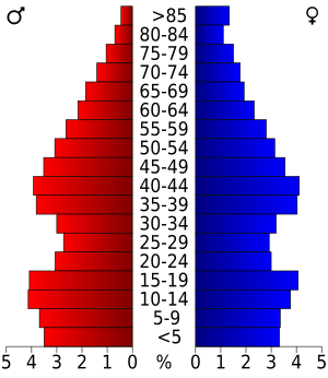
The population in the county was spread out by age. About 26.70% were under 18 years old. About 9.30% were between 18 and 24. The median age in the county was 36 years old. This means half the people were younger than 36, and half were older.
Communities in Grady County
Cities
- Blanchard (partially in McClain County)
- Chickasha (the county seat)
- Minco
- Tuttle
Towns
Unincorporated Communities
These are smaller communities that are not officially cities or towns.
Ghost Towns
These are places that used to be towns but are now abandoned.
Historic Places (NRHP Sites)
Many places in Grady County are listed on the National Register of Historic Places. This means they are important historical sites that are protected. Here are some of them:
- Chickasha Downtown Historic District, Chickasha
- Grady County Courthouse, Chickasha
- Griffin House, Chickasha
- Jewett Site, Bradley
- Knippelmeir Farmstead, Minco vicinity
- Minco Armory, Minco
- New Hope Baptist Church, Chickasha
- Oklahoma College for Women Historic District, Chickasha
- Pocasset Gymnasium, Pocasset
- Rock Island Depot, Chickasha
- Silver City Cemetery, Tuttle
- US Post Office and Federal Courthouse, Chickasha
- Verden Separate School, originally in Verden but relocated to Chickasha
Notable People
- Tomassa (c. 1840–1900), a translator who lived in the area.
See also
 In Spanish: Condado de Grady (Oklahoma) para niños
 | Janet Taylor Pickett |
 | Synthia Saint James |
 | Howardena Pindell |
 | Faith Ringgold |


