McClain County, Oklahoma facts for kids
Quick facts for kids
McClain County
|
|
|---|---|

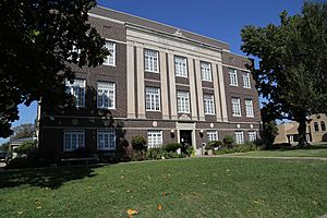
McClain County Courthouse
|
|

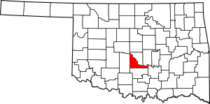
Location within the U.S. state of Oklahoma
|
|
 Oklahoma's location within the U.S. |
|
| Country | |
| State | |
| Founded | 1907 |
| Seat | Purcell |
| Largest city | Newcastle |
| Area | |
| • Total | 580 sq mi (1,500 km2) |
| • Land | 571 sq mi (1,480 km2) |
| • Water | 9.6 sq mi (25 km2) 1.6%% |
| Population
(2020)
|
|
| • Total | 41,662 |
| • Density | 71.8/sq mi (27.73/km2) |
| Time zone | UTC−6 (Central) |
| • Summer (DST) | UTC−5 (CDT) |
| Congressional district | 4th |
McClain County is a county located in south central Oklahoma. In 2020, about 41,662 people lived here. Its main town, or county seat, is Purcell. The county was named after Charles M. McClain, who helped write Oklahoma's constitution.
McClain County is part of the larger Oklahoma City area. This means it's connected to the big city's economy and culture.
Contents
History
The Chickasaw tribe started moving into this area in 1837. This land had already been given to the Choctaw tribe by the U.S. government. In 1855, the area officially became part of the Chickasaw Nation. This happened after the Chickasaw and Choctaw tribes separated.
The land that is now McClain County was part of Pontotoc County in the Chickasaw Nation. It stayed that way until Oklahoma became a state. Not many Chickasaws lived here because of conflicts with other tribes.
In 1835, Major Richard Mason set up Camp Holmes. This camp was near the city of Lexington today. He was working on a peace treaty between western tribes and the new Choctaw arrivals. U.S. troops left the camp in August 1835 after the treaty was signed.
Auguste Pierre Chouteau built a trading post at the Camp Holmes site. But it closed after he passed away in 1838. Randolph Marcy helped create the California Road in 1849. This important road passed through this area. The U.S. Army built Camp Arbuckle in 1850 to protect the road. However, the troops moved to what is now Garvin County, Oklahoma the next year.
Jesse Chisholm also ran a trading post here around 1850. A group of Delaware Indians lived at the old camp, then called Beaversville. They left before the Civil War began.
After the Civil War, a rancher named Montford T. Johnson moved to this area. He and Jesse Chisholm worked out a deal with the Chickasaw leaders. They allowed ranching on their land. The only rule was that no white people could be hired. Johnson then built a ranch and hired a Chickasaw freedman to run it. He later set up more ranches and hired other freedmen to manage them.
Railroads played a big part in the county's growth. The Southern Kansas Railway built a line from Kansas in 1886–87. The Gulf, Colorado and Santa Fe Railway built a line north from Texas. These lines met and started the town of Purcell. Other railroads also built tracks through the county. This helped establish towns like Washington, Cole, and Blanchard.
Purcell was the starting point for the Land Run of 1889. It was also on the border between Indian Territory and Oklahoma Territory. In Indian Territory, selling alcohol was not allowed. But in Oklahoma Territory, it was legal. Lexington, a town across the river from Purcell, had many places that sold alcohol. In 1899, the Purcell Bridge Company built a toll bridge. This bridge helped people cross the river and made money from the alcohol trade.
Geography
McClain County covers about 580 square miles. Most of this area, 571 square miles, is land. About 9.6 square miles (1.6%) is water. The county is mostly in the Red Bed Plains region. The western part of the county has hills and oak trees. The eastern part is flat lowlands.
The South Canadian River forms the northern border of the county. The Washita River flows through the southwestern part. Several creeks in McClain County flow into the Washita River.
Adjacent counties
- Cleveland County (north)
- Pottawatomie County (northeast)
- Pontotoc County (east)
- Garvin County (south)
- Grady County (west)
Population and People
| Historical population | |||
|---|---|---|---|
| Census | Pop. | %± | |
| 1910 | 15,659 | — | |
| 1920 | 19,326 | 23.4% | |
| 1930 | 21,575 | 11.6% | |
| 1940 | 19,205 | −11.0% | |
| 1950 | 14,681 | −23.6% | |
| 1960 | 12,740 | −13.2% | |
| 1970 | 14,157 | 11.1% | |
| 1980 | 20,291 | 43.3% | |
| 1990 | 22,795 | 12.3% | |
| 2000 | 27,740 | 21.7% | |
| 2010 | 34,506 | 24.4% | |
| 2020 | 41,662 | 20.7% | |
| 2023 (est.) | 47,072 | 36.4% | |
| U.S. Decennial Census 1790-1960 1900-1990 1990-2000 2010-2019 |
|||
In 2010, there were 34,506 people living in McClain County. There were 12,891 households, which are groups of people living together. About 9,785 of these were families. The county had about 59.5 people per square mile.
Most people in the county were white (84.5%). About 6.4% were Native American. Seven percent of the population was Hispanic or Latino. By 2020, the population grew to 41,662 people.
In 2010, about 37.4% of households had children under 18. Most households (61.3%) were married couples living together. The average household had 2.66 people. The average family had 3.06 people.
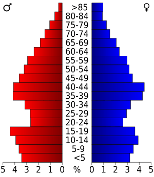
The population was spread out by age. About 26.6% were under 18 years old. About 13.2% were 65 years or older. The average age was 38.2 years.
Economy
The economy in McClain County has mostly been about farming and raising cattle. In the early 1900s, each town had its own cotton gin. Purcell also had a flour mill. There wasn't much other industry back then.
Today, many people who live in McClain County travel to work in the Oklahoma City area. In 1971, the Mid-America Area Vo-Tech school opened. It helps students learn job skills. A power plant was built near Newcastle in 2001. The Chickasaw Nation also runs a gaming casino in Newcastle.
Education
K-12 schools
Here are the school districts in McClain County:
- Alex Public Schools
- Asher Public Schools
- Blanchard Public Schools
- Bridge Creek Public Schools
- Dibble Public Schools
- Lindsay Public Schools
- Maysville Public Schools
- Newcastle Public Schools
- Norman Public Schools
- Paoli Public Schools
- Purcell Public Schools
- Stratford Public Schools
- Washington Public Schools
- Wayne Public Schools
Libraries
The Pioneer Library System runs libraries in nine cities. These cities are in Cleveland, McClain, and Pottawatomie counties. The Purcell Public Library is the only one in McClain County that is part of this system. You can find it at 919 N. 9th Street in Purcell.
Transportation
Major highways
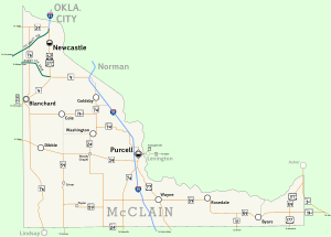
The busiest highway in McClain County is Interstate 35. It enters the county from the north at Goldsby. It then runs next to the Canadian River through Purcell, the county seat. Finally, it heads south and leaves the county at the border with Garvin County.
Another important highway is Interstate 44. It goes through the northwestern part of the county. The H.E. Bailey Turnpike Norman Spur connects this highway to other main roads.
SH-9 also enters McClain County. It runs along the northern edge of Goldsby. It then meets U.S. Highway 62 and U.S. Highway 277. These highways continue southwest towards Blanchard and Chickasha.
 Interstate 35
 Interstate 44
 H.E. Bailey Turnpike
 U.S. Highway 62
 U.S. Highway 77
 U.S. Highway 177
 U.S. Highway 277
 State Highway 4
 State Highway 9
 State Highway 39
 State Highway 59
 State Highway 74
 State Highway 76
County roads
McClain County has many roads maintained by the county. They form a grid, with parallel roads usually one mile apart.
To make things clearer, especially for new 9-1-1 systems, the county roads were recently renamed. East-west roads are numbered. For example, 100th Street is along the southern edge of the county. North-south streets are named, often matching names of streets in Oklahoma City.
Communities
Cities
- Blanchard (also partly in Grady County)
- Newcastle
- Purcell (county seat; small part in Cleveland County)
Towns
- Byars
- Cole
- Dibble
- Goldsby
- Maysville (also partly in Garvin County)
- Rosedale
- Washington
- Wayne
Unincorporated communities
Local landmarks
The following places in McClain County are listed on the National Register of Historic Places. This means they are important historical sites:
- Hotel Love, Purcell
- McClain County Courthouse, Purcell
- James C. Nance Memorial Bridge (U.S. Highway 77/State Highway 39 Bridge over the Canadian River), Purcell/Lexington
Images for kids
See also
 In Spanish: Condado de McClain para niños
 | Georgia Louise Harris Brown |
 | Julian Abele |
 | Norma Merrick Sklarek |
 | William Sidney Pittman |


